Fort Snelling (unorganized territory), Minnesota
Fort Snelling is an unorganized territory of Hennepin County, Minnesota, United States named after historic Fort Snelling, located within its boundaries. The territory also includes Minneapolis-Saint Paul International Airport and various government facilities, and as of the 2010 census had a population of 149.
Fort Snelling | |
|---|---|
 Aerial photograph of Minneapolis–St. Paul International Airport showing much of the unorganized territory of Fort Snelling. The historic fort is by the confluence of the Mississippi and Minnesota toward the upper right of the photograph, and Fort Snelling National Cemetery is at center right. | |
 Fort Snelling Location within the state of Minnesota | |
| Coordinates: 44°53′34″N 93°10′50″W | |
| Country | United States |
| State | Minnesota |
| County | Hennepin County |
| Time zone | UTC-6 (Central (CST)) |
| • Summer (DST) | UTC-5 (CDT) |
Geography

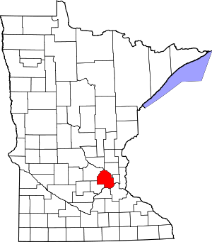
The unorganized territory of Fort Snelling is a division of Hennepin County lying just east of the city of Richfield. Historic Fort Snelling is located at the eastern end of the territory, near the confluence of the Mississippi River with the Minnesota River. Within Hennepin County it also borders Minneapolis to the north and Bloomington to the southwest, while across the Mississippi River is Saint Paul in Ramsey County, and across the Minnesota River are Mendota and Mendota Heights in Dakota County. For postal purposes, the eastern portion addresses in the unorganized territory (including Terminal 1 of the Minneapolis St. Paul International Airport and the Fort Snelling historic site) are in zip code 55111 with a Saint Paul mailing address, while addresses in the western part of the territory (including the airport's Terminal 2 and the Metropolitan Airports Commission offices) are in zip code 55450 and have a Minneapolis mailing address.[1] According to the United States Census Bureau, this unorganized territory has a total area of 17.2 km2 (6.7 mi2). 16.5 km2 (6.4 mi2) of it is land and 0.8 km2 (0.3 mi2) of it is water.
Fort Snelling's territory contains numerous military and other federal facilities. These facilities include the current National Guard base at Fort Snelling, Fort Snelling National Cemetery, and the Minneapolis Veterans Health Administration Medical Center. Several facilities belonging to Minnesota state government agencies such as the Minnesota Department of Transportation are also located in the territory, as are the headquarters and portions of Fort Snelling State Park and the Minnesota Valley National Wildlife Refuge. Minneapolis-Saint Paul International Airport, however, includes most of the land area of the unorganized territory.
Demographics
| Historical population | |||
|---|---|---|---|
| Census | Pop. | %± | |
| 1880 | 352 | — | |
| 1890 | 550 | 56.3% | |
| 1930 | 2,043 | — | |
| 1940 | 2,972 | 45.5% | |
| 1950 | 2,584 | −13.1% | |
| 1960 | 898 | −65.2% | |
| 1970 | 624 | −30.5% | |
| 1980 | 223 | −64.3% | |
| 1990 | 97 | −56.5% | |
| 2000 | 442 | 355.7% | |
| 2010 | 149 | −66.3% | |
| U.S. Decennial Census[2] | |||
Fort Snelling was listed as an incorporated village during the 1890 Census.[2]
Most people resident in the unorganized territory are service members stationed at the barracks at Fort Snelling. The number of troops stationed there has declined over the years; between the 2000 and 2010 censuses the population dropped from 442 to 149. Since then, however, a small amount of private housing in the old fort's Upper Post area has been developed or planned, so the population will likely increase again.
As of the census[3] of 2000, 442 people resided in the unorganized territory. The population density was 26.8/km² (69.5/mi²). The racial makeup of the unorganized territory was 94.57% White, 3.62% Black or African American, 1.36% Native American, 0.00% Asian, 0.23% Pacific Islander, and 0.23% of other races. 0.45% of the population was Hispanic or Latino of any race. The population is spread out in age with 4.5% from 25 to 44, 33.0% from 45 to 64, and 62.4% who were 65 years of age or older. The median age was 69 years. Males had a median income of $43,558 versus $0 for females. The per capita income was $24,328. None of the population was below the poverty line.
Airport and economy
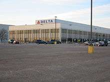
Delta Air Lines Building C is located on the property of Minneapolis–St. Paul International Airport and in Fort Snelling.[4][5][6][7] Delta uses it for northern and regional operations.[8]
In 2009, as Northwest Airlines and Delta Airlines merged, Delta removed all employees from Building A, the previous headquarters of Northwest in Eagan, and all employees who remained in Minneapolis were moved to Building C, which was renovated.[9] Facilities within the building include the Compass Airlines corporate headquarters, which moved there on December 16, 2009,[10] the Regional Elite Airline Services headquarters,[11] and Delta SkyBonus offices.[12]
References
- "Minnesota Zip Code Boundary Map (MN)". www.zipmap.net. Retrieved 2018-03-04.
- United States Census Bureau. "Census of Population and Housing". Retrieved July 23, 2014.
- "U.S. Census website". United States Census Bureau. Retrieved 2008-01-31.
- "delta air lines' farmers market-building c". Minneapolis–St. Paul International Airport. Retrieved on January 19, 2012. "Location: MSP Airport-Delta Building C, North Side near Compass Airlines Entrance"
- "Fort Snelling UT, Hennepin county, Minnesota". (Archive) U.S. Census Bureau. Retrieved on December 19, 2009.
- "Expanded Branch and ATM Access Comes to the Twin Cities Archived 2012-03-18 at the Wayback Machine". Wings Financial. Retrieved on January 19, 2012. "Delta Air Lines Bldg. C* 7500 Airline Drive Minneapolis, MN"
- "Blood Drive | Delta Air Lines Bldg C". Memorial Blood Centers. Retrieved on January 19, 2012. "Street: 7500 Airline Drive City: Bloomington State: Minnesota Country: USA"
- Niemela, Jennifer. "Delta reaches deal on Minnesota jobs". Minneapolis / St. Paul Business Journal. Tuesday December 16, 2008. Retrieved on January 19, 2012.
- Grayson, Katharine. "Delta CEO: We'll consolidate MSP office space". Minneapolis / St. Paul Business Journal. Friday June 12, 2009. Last modified on Monday June 15, 2009. Retrieved on January 19, 2012.
- "About Us Archived July 11, 2007, at the Wayback Machine". Compass Airlines. Retrieved on December 18, 2009. "7500 Airline Drive Suite 130 Minneapolis, Minnesota 55450"
- "CR-7010-Docket.pdf". Unity and Strength For Workers. Retrieved on January 19, 2012. "Regional Elite Airline Services 7500 Airline Drive C079 Minneapolis, MN 55450-1101"
- "Contact us". Delta SkyBonus. Retrieved on January 19, 2012. "SkyBonus® MS3-746 7500 Airline Drive Minneapolis, MN 55450"
Municipalities and communities of Hennepin County, Minnesota, United States | ||
|---|---|---|
| Cities |
|  Map of Minnesota highlighting Hennepin County |
| Unorganized territory | ||
| Footnotes | ‡This populated place also has portions in an adjacent county or counties | |