Fort Hall, Idaho
Fort Hall is a census-designated place (CDP) in the southeastern part of the U.S. state of Idaho which is split between Bannock County in the south and Bingham County in the north. It is located on the Fort Hall Indian Reservation along the Snake River north of Pocatello and near the site of the original Fort Hall in the Oregon Country. The population was 3,201 at the 2010 census.[1]
Fort Hall, Idaho | |
|---|---|
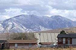 Houses in Fort Hall, Idaho | |
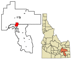 Location of Fort Hall, Idaho | |
| Coordinates: 43°1′7″N 112°26′54″W | |
| Country | United States |
| State | Idaho |
| Counties | Bannock, Bingham |
| Area | |
| • Total | 35.2 sq mi (91 km2) |
| • Land | 35.2 sq mi (91 km2) |
| • Water | 0.0 sq mi (0 km2) |
| Elevation | 4,442 ft (1,354 m) |
| Population (2010) | |
| • Total | 3,201 |
| • Density | 91/sq mi (35/km2) |
| Time zone | UTC-7 (Mountain (MST)) |
| • Summer (DST) | UTC-6 (MDT) |
| ZIP code | 83203 |
| Area code(s) | 208, 986 |
| FIPS code | 16-28360 |
| GNIS feature ID | 0396503 |
The Bannock County portion of Fort Hall is part of the 'Pocatello, Idaho Metropolitan Statistical Area', while the Bingham County portion is part of the 'Blackfoot, Idaho Micropolitan Statistical Area'.
Geography
Fort Hall is located at 43°1′7″N 112°26′54″W (43.018506, -112.448301).[2]
According to the United States Census Bureau, the CDP has a total area of 35.2 square miles (91 km2), all of it land.
Climate
According to the Köppen Climate Classification system, Fort Hall has a semi-arid climate, abbreviated "BSk" on climate maps.[3]
Demographics
| Historical population | |||
|---|---|---|---|
| Census | Pop. | %± | |
| U.S. Decennial Census[4] | |||
At the 2000 census there were 3,193 people, 969 households, and 781 families in the CDP. The population density was 90.8 people per square mile (35.1/km²). There were 1,088 housing units at an average density of 30.9/sq mi (11.9/km²). The racial makeup of the CDP was 30.22% White, 0.03% African American, 65.39% Native American, 0.31% Asian, 0.03% Pacific Islander, 2.25% from other races, and 1.75% from two or more races. Hispanic or Latino of any race were 7.61%.[5]
Of the 969 households 42.2% had children under the age of 18 living with them, 49.6% were married couples living together, 22.5% had a female householder with no husband present, and 19.3% were non-families. 16.3% of households were one person and 4.4% were one person aged 65 or older. The average household size was 3.26 and the average family size was 3.63.
The age distribution was 34.7% under the age of 18, 11.3% from 18 to 24, 28.2% from 25 to 44, 18.5% from 45 to 64, and 7.3% 65 or older. The median age was 28 years. For every 100 females, there were 94.7 males. For every 100 females age 18 and over, there were 92.3 males.
The median household income was $30,313 and the median family income was $32,256. Males had a median income of $27,310 versus $21,544 for females. The per capita income for the CDP was $10,563. About 22.6% of families and 27.2% of the population were below the poverty line, including 32.5% of those under age 18 and 26.9% of those age 65 or over.
References
- "U.S. Census website". U.S. Census Bureau. Retrieved 22 March 2011.
- "US Gazetteer files: 2010, 2000, and 1990". United States Census Bureau. 2011-02-12. Retrieved 2011-04-23.
- Climate Summary for Fort Hall, Idaho
- "Census of Population and Housing". Census.gov. Retrieved June 4, 2016.
- "U.S. Census website". United States Census Bureau. Retrieved 2008-01-31.
External links
![]()
Municipalities and communities of Bannock County, Idaho, United States | ||
|---|---|---|
| Cities | Map of Idaho highlighting Bannock County | |
| CDPs | ||
| Unincorporated communities | ||
| Indian reservation | ||
| Ghost town | ||
Municipalities and communities of Bingham County, Idaho, United States | ||
|---|---|---|
| Cities | Map of Idaho highlighting Bingham County | |
| CDPs | ||
| Unincorporated communities | ||
| Indian reservation | ||
| Footnotes | ‡This populated place also has portions in an adjacent county or counties | |
| Authority control |
|
|---|