Florida's 26th congressional district
Florida's 26th congressional district is an electoral district for the U.S. Congress, which was created in South Florida during 2012, effective January 2013, as a result of the 2010 Census.[6] The first candidates ran in the 2012 House elections, and the winner was seated for the 113th Congress on January 3, 2013.
| Florida's 26th congressional district | |||
|---|---|---|---|
 Florida's 26th congressional district since January 3, 2017 | |||
| Representative |
| ||
| Area | 5,171[1] sq mi (13,390 km2) | ||
| Distribution |
| ||
| Population (2016) | 788,816[3] | ||
| Median income | $61,501[4] | ||
| Ethnicity |
| ||
| Cook PVI | D+6[5] | ||
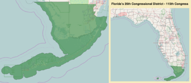
The 26th district is located in far South Florida, and contains all of Monroe County as well as a portion of south-west Miami-Dade County.[7][8] Geographically, it is the successor to the old 25th District. This district includes Homestead, Key Largo, Marathon, and Key West. This district includes Florida International University and Key West International Airport. All three of Florida's National Parks, the Everglades, Biscayne, and the Dry Tortugas, lie in this district.
Democrat Debbie Mucarsel-Powell currently represents the district.
Statewide election results
Election results from previous statewide elections.
| Year | Office | Results |
|---|---|---|
| 2012 | President | Barack Obama 55.4 - Mitt Romney 43.9% |
| 2016 | President | Hillary Clinton 56.7 - Donald Trump 40.6% |
| 2016 | Senate | Marco Rubio 49.4 - Patrick Murphy 48.1% |
List of members representing the district
| Representative | Party | Years | Congress | Electoral history | Geography |
|---|---|---|---|---|---|
| District created | January 3, 2013 | ||||
 Joe Garcia |
Democratic | January 3, 2013 – January 3, 2015 |
113th | Elected in 2012. Lost re-election. |
.tif.png) 2013 - 2017 |
 Carlos Curbelo |
Republican | January 3, 2015 – January 3, 2019 |
114th 115th |
Elected in 2014. Re-elected in 2016. Lost re-election. | |
Since 2017 | |||||
 Debbie Mucarsel-Powell |
Democratic | January 3, 2019 – Present |
116th | Elected in 2018. | |
References
- "Congressional Plan--SC14-1905 (Ordered by The Florida Supreme Court, 2-December-2015)" (PDF). Florida Senate Committee on Reapportionment. Retrieved January 11, 2017.
- Geography, US Census Bureau. "Congressional Districts Relationship Files (state-based)". www.census.gov.
- Bureau, Center for New Media & Promotion (CNMP), US Census. "My Congressional District". www.census.gov.
- https://www.census.gov/mycd/?st=12&cd=26
- "Partisan Voting Index – Districts of the 115th Congress" (PDF). The Cook Political Report. April 7, 2017. Retrieved April 7, 2017.
- "Census 2010 shows Red states gaining congressional districts". Washington Post. Retrieved December 21, 2010.
- See whole Florida state map for 2013, with the 26th district covering Monroe County and Miami-Dade County: h9047_35x42L.pdf Congressional Plan: H000C9047. Chapter No. 2012-2, Laws of Florida. www.flsenate.gov. February 16, 2012.
- See the 2013 boundaries of the 26th district, covering Monroe County and western Miami-Dade in the 2013 districts map: H000C9047_map_se.pdf, for the southeast region of Florida. Congressional Plan: H000C9047. Chapter No. 2012-2, Laws of Florida. www.flsenate.gov. February 2012.