Flinders Chase National Park
Flinders Chase National Park (formerly Flinders Chase) is a protected area in the Australian state of South Australia located at the west end of Kangaroo Island about 177 kilometres (110 miles) west-south west of the state capital of Adelaide and 110 kilometres (68 miles) west of the municipal seat of Kingscote. It is a sanctuary for endangered species and home to a few geological phenomena. It was the second national park to be declared in South Australia.[4]
| Flinders Chase National Park South Australia | |
|---|---|
IUCN category II (national park)[1] | |
 Remarkable Rocks, in the southern part of the park | |
 Flinders Chase National Park | |
| Nearest town or city | Kingscote |
| Coordinates | 35°58′38″S 136°40′22″E |
| Established | 1919 1972 (national park)[2][3] |
| Area | 326.61 km2 (126.1 sq mi)[1] |
| Managing authorities | Department for Environment and Water |
| Website | Flinders Chase National Park |
| See also | Protected areas of South Australia |
Flinders Chase National Park consists of three sections - an area of coastal landscapes around Cape du Couedic in the south west corner of the island, the Gosse Lands in the centre of the west end of the island and the former Cape Borda Lightstation reserve in the north west corner of the island.
Description
Location
Flinders Chase National Park is located at the north-western end of Kangaroo Island in South Australia approximately 110 kilometres (68 miles) west of Kingscote.[5] It is located within the gazetted localities of Flinders Chase, Gosse and Karatta.[6][7][8]
Extent
As of 1993, the national park consists of three separate parcels of land:[5][9]
- 'Cape du Couedic' which is refers to the main parcel of land within the national park and which is bounded at the north by the West Bay Road and the West Melrose Track, to the east by the West End Highway and an unsealed track called the Sand Dune Track; and the portion of coastline extending from West Bay in the west to Cape du Couedic in the south and to Sanderson Bay in the east. This portion of the national park includes the following islands - Paisley Islet (also known as West Bay Island) at West Bay and the Casuarina Islets immediately south of Cape du Couedic.
- The Gosse Lands - a parcel of land which is bounded by the Playford Highway to the north and the West End Highway to the west.
- The former lighthouse reserve at Cape Borda.
Protected area designation
The national park is classified as an IUCN category II protected area.[1]
History
Parts of the national park first acquired protected area status as a ‘flora and fauna reserve’ declared on 16 October 1919 under the Fauna and Flora Reserve Act 1919, an act whose specific purpose was:[2]
…to establish a Reserve on Kangaroo Island for the Protection, Preservation, and Propagation of Australasian Fauna and Flora, and to provide for the Control of such Reserve, and for other purposes.
It was constituted as a national park upon the proclamation of the National Parks and Wildlife Act 1972 on 27 April 1972 which repealed five items of existing legislation including the Fauna and Flora Reserve Act 1919.[3] At proclamation in 1972, it consisted of the following land in the following cadastral units as well as the entirety of the Casuarina Islets - section 11 in the Hundred of Borda, section 64 in the Hundred of Gosse, section 17 in the Hundred of McDonald and section 66 in "South out of Hundreds".[10]
On 15 October 1993, land in section 11 of the Hundred of Borda, section 64 of Hundred of Gosse and Allotments 50 and 52 in DP 38340 and with an area of 416.63 square kilometres (160.86 sq mi) was removed from the national park and consitututed under the Wilderness Protection Act 1992 as the Ravine des Casoars Wilderness Protection Area.[1][11]
Sanctuary
Since creation in November 1919, it has become a sanctuary for endangered species, some of them introduced from the mainland in the 1920s and 1930s. During the 1940s, 23 additional species were introduced, including Koalas (1923) and Platypus (1928). Most of these species can still be observed today. Kangaroos, Goannas and Echidnas are commonly seen in the national park.
Little penguins
Little penguins have been recorded in Flinders Chase in the 1920s,[12] 1930s,[13][14] 1940s[15] and 1950s.[16] It is believed that these colonies have since gone extinct, partly due to the increase of long-nosed fur seal populations since the end of commercial sealing. In 1886, little penguins were seen at Admiral's Arch.[17]
Geological monuments
The national park contains two geological features that have been listed as geological monuments by the Geological Society of Australia - Cape du Couedic and Remarkable Rocks.[18]
Remarkable Rocks are naturally sculptured formations precariously balanced atop a granite outcrop. They remind visitors of the sculptures of Henry Moore.[19]
Fire
Lightning strikes on Thursday 6 December 2007 caused approximately 60,000 hectares (150,000 acres) of land in both the national park and the adjoining Ravine des Casoars Wilderness Protection Area to be burnt, before being brought under control ten days later.[20] The national park was again damaged during the 2019–20 Australian bushfire season,[21] with the Visitor Centre completely destroyed.
Gallery
 Echidna at Flinders Chase National Park
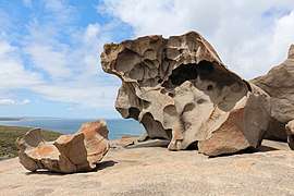 Remarkable Rocks
 Admirals Arch
 View from Bunker Hill lookout
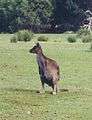
See also
References
- "Terrestrial Protected Areas of South Australia (refer 'DETAIL' tab )". CAPAD 2016. Australian Government, Department of the Environment (DoE). 2016. Retrieved 21 February 2018.
- "Chief Secretary's Office, Adelaide, October 16th, 1919. (i.e. acts assented to by the Governor)" (PDF). The South Australian Government Gazette. Government of South Australia: 949. 19 October 1919. Retrieved 21 May 2017.
- "Chief Secretary's Department, Adelaide, 27th April, 1972, list of act assented to by the" (PDF). The South Australian Government Gazette. Government of South Australia: 1633. 27 April 1972. Retrieved 21 May 2017.
- flightcentre.com.aufailed verification]
- "Flinders Chase National Park, Kelly Hill Conservation Park, Ravine des Casoars Wilderness Protection Area and Cape Bouguer Wilderness Protection Area Management Plans" (PDF). Department for Environment, Heritage and Aboriginal Affairs. 1999. p. 5. Retrieved 1 May 2014.
- "Search result for "Flinders Chase (Locality Bounded)" (Record no SA0058416 ) with the following layers being selected - "Suburbs and Localities"and "Road Labels"". Department of Planning, Transport and Infrastructure. Retrieved 6 March 2016.
- "Search result for "Gosse (Locality Bounded)" (Record no SA0027114) with the following layers selected - "Suburbs and Localities" and "Road Labels"". Department of Planning, Transport and Infrastructure. Retrieved 8 March 2016.
- "Search result for "Karatta (Locality Bounded)" (Record no SA0034161) with the following layers selected - "Suburbs and Localities" and "Road Labels"". Department of Planning, Transport and Infrastructure. Retrieved 8 March 2016.
- "Protected Areas of South Australia September (Map) 2015 Edition" (PDF). Department of Environment, Water and Natural Resources (DEWNR). 30 July 2015. Retrieved 15 April 2015.
- "No. 56 of 1972 (National Parks and Wildlife Act, 1972)". Government of South Australia. 27 April 1972: 660 & 699. Retrieved 20 January 2017. Cite journal requires
|journal=(help) - Wiese, B.J. (15 October 1993). "WILDERNESS PROTECTION ACT 1992 SECTION 22(1): CONSTITUTION OF RAVINE DES CASOARS WILDERNESS PROTECTION AREA" (PDF). The South Australian Government Gazette. Government of South Australia. p. 1755. Retrieved 25 January 2019.
- "Cape de Coudie Light. Guarding rocky coast. Lighthouse keeper's life." The Mail, South Australia (1926-01-23). Retrieved 2014-03-13.
- Hill, Ernestine "A Southern Eden. Flinders Chase and its family" The Advertiser, South Australia (1936-09-05). Retrieved 2014-03-13.
- "Sanctuary - Flinders Chase" The Mail, South Australia (1935-03-30). Retrieved 2014-03-13.
- "Preserving our wildlife - Work being done at Flinders Chase" The Advertiser, South Australi (1946-02-13). Retrieved 2014-03-12.
- N.Q. Naturalists Club "Current Nature Notes. Flinders Chase, Kangaroo Island." Townsville Daily Bulletin, Queensland, Australia (1953-04-25). Retrieved 2014-03-13.
- "Trip across Kangaroo Island" South Australian Register, South Australia (1886-12-07). Retrieved 2014-03-13.
- Kangaroo Island Natural Resources Management Board (2009), Here to stay for our children and grandchildren : a natural resources management plan for the Kangaroo Island region 2009 (PDF), 1, Kangaroo Island Natural Resources Management Board, pp. 88–89, ISBN 978-1-921595-00-4
- Alice Reid (12 July 2009). "Kangaroo Island Will Drive You Wild". The Washington Post.
The "Remarkable Rocks," as they are called, are a collection of enormous eroded granite boulders sitting atop a giant dome of lava coughed up about 200 million years ago. Wind and sea spray have since carved the chunks into what look like monumental Henry Moore sculptures perched 200 feet above a crashing sea.
- "Flinders Chase Fire Management Plan 2009-2014 (Incorporating Flinders Chase National Park, Ravine des Casoars Wilderness Protection Area, Cape Bouguer Wilderness Protection Area and Kelly Hill Conservation Park)" (PDF). Department for Environment and Heritage, Government of South Australia. September 2009. p. 14. Retrieved 8 January 2020.
- https://www.theguardian.com/australia-news/gallery/2020/jan/08/scorched-earth-the-bushfire-devastation-on-kangaroo-island-in-pictures
External links
| Wikimedia Commons has media related to Flinders Chase National Park. |
| Wikivoyage has a travel guide for Flinders Chase National Park. |
- Flinders Chase National Park official webpage
- Flinders Chase National Park webpage on protected planet
| Major townships | |||||||||
|---|---|---|---|---|---|---|---|---|---|
| Beaches | |||||||||
| Coastal features |
| ||||||||
| Protected areas |
| ||||||||
| Islands adjacent to Kangaroo Island coast | |||||||||
| Related and uncategorised | |||||||||
| |||||||||
| Authority control |
|
|---|