Fichtwald
Fichtwald is a municipality in the Elbe-Elster district, in Brandenburg, Germany.
Fichtwald | |
|---|---|
Location of Fichtwald within Elbe-Elster district 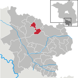 | |
 Fichtwald  Fichtwald | |
| Coordinates: 51°42′00″N 13°28′00″E | |
| Country | Germany |
| State | Brandenburg |
| District | Elbe-Elster |
| Municipal assoc. | Schlieben |
| Subdivisions | 3 Ortsteile |
| Government | |
| • Mayor | Reinhard Schulze (Ind.) |
| Area | |
| • Total | 31.55 km2 (12.18 sq mi) |
| Elevation | 112 m (367 ft) |
| Population (2018-12-31)[1] | |
| • Total | 614 |
| • Density | 19/km2 (50/sq mi) |
| Time zone | CET/CEST (UTC+1/+2) |
| Postal codes | 04936 |
| Dialling codes | 035361 |
| Vehicle registration | EE, FI, LIB |
Demography
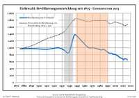 Development of population since 1875 within the current boundaries (Blue line: population; dotted line: Comparison to population development of Brandenburg state; grey background: Time of Nazi rule; red background: Time of communist rule)
| Fichtwald: Population development within the current boundaries (2017)[2] | ||||||||||||||||||||||||||||||||||||||||||||||||||||||||||||||||||||||||||||||||||||||||||||||||||||||||||||||||||||||||||||||||||||||
|---|---|---|---|---|---|---|---|---|---|---|---|---|---|---|---|---|---|---|---|---|---|---|---|---|---|---|---|---|---|---|---|---|---|---|---|---|---|---|---|---|---|---|---|---|---|---|---|---|---|---|---|---|---|---|---|---|---|---|---|---|---|---|---|---|---|---|---|---|---|---|---|---|---|---|---|---|---|---|---|---|---|---|---|---|---|---|---|---|---|---|---|---|---|---|---|---|---|---|---|---|---|---|---|---|---|---|---|---|---|---|---|---|---|---|---|---|---|---|---|---|---|---|---|---|---|---|---|---|---|---|---|---|---|---|
|
|
| ||||||||||||||||||||||||||||||||||||||||||||||||||||||||||||||||||||||||||||||||||||||||||||||||||||||||||||||||||||||||||||||||||||
External links
| Wikimedia Commons has media related to Fichtwald. |
References
- "Bevölkerung im Land Brandenburg nach amtsfreien Gemeinden, Ämtern und Gemeinden 31. Dezember 2018". Amt für Statistik Berlin-Brandenburg (in German). July 2019.
- Detailed data sources are to be found in the Wikimedia Commons.Population Projection Brandenburg at Wikimedia Commons
Towns and municipalities in Elbe-Elster | ||
|---|---|---|
| Coat of Arms of Elbe-Elster district | |
This article is issued from Wikipedia. The text is licensed under Creative Commons - Attribution - Sharealike. Additional terms may apply for the media files.