Falkenberg/Elster
Falkenberg is a town in the Elbe-Elster district, in southwestern Brandenburg, Germany. It is situated near the river Schwarze Elster, 16 km east of Torgau, and 13 km northwest of Bad Liebenwerda.
Falkenberg/Elster | |
|---|---|
 Church in Falkenberg/Elster | |
 Coat of arms | |
Location of Falkenberg/Elster within Elbe-Elster district 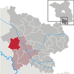 | |
 Falkenberg/Elster  Falkenberg/Elster | |
| Coordinates: 51°34′59″N 13°13′56″E | |
| Country | Germany |
| State | Brandenburg |
| District | Elbe-Elster |
| Municipal assoc. | Liebenwerda |
| Subdivisions | 5 Ortsteile |
| Government | |
| • Mayor | Herold Quick (SPD) |
| Area | |
| • Total | 81.80 km2 (31.58 sq mi) |
| Elevation | 86 m (282 ft) |
| Population (2018-12-31)[1] | |
| • Total | 6,368 |
| • Density | 78/km2 (200/sq mi) |
| Time zone | CET/CEST (UTC+1/+2) |
| Postal codes | 04895 |
| Dialling codes | 035365 |
| Vehicle registration | EE, FI, LIB |
| Website | www.falkenberg-elster.de |
History
It was first mentioned in 1251. In 1547 the Battle of Mühlberg was decided in the vicinity of Falkenberg when the Saxon prince-elector Johann Friedrich I. was taken prisoner. The village itself remained of low importance until the 19th century. The manor changed hands several times, until it was bought by the municipality in 1911. In 1848, Falkenberg (Elster) station was opened on the railway Jüterbog–Röderau railway. The Halle–Cottbus railway was opened in 1872 and crossed the former at Falkenberg which became a major junction and grew considerably. Industry and businesses were established, including a power station. World War II caused major destruction. In 1962 Falkenberg was awarded town privileges. The coat of arms reflects the major branches of economy in the town: energy supply, railway, and agriculture.
Large numbers of derelict steam locomotives are stored at an old railway depot just to the north-east.
Demography
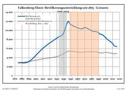 Development of Population since 1875 within the Current Boundaries (Blue Line: Population; Dotted Line: Comparison to Population Development of Brandenburg state; Grey Background: Time of Nazi rule; Red Background: Time of Communist rule)
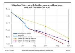 Recent Population Development (Blue Line) and Forecasts
| Falkenberg/Elster: Population development within the current boundaries (2017)[2] | |||||||||||||||||||||||||||||||||||||||||||||||||||||||||||||||||||||||||||||||||||||||||||||||||||||||||||||||||||||||||||||||||||||||||
|---|---|---|---|---|---|---|---|---|---|---|---|---|---|---|---|---|---|---|---|---|---|---|---|---|---|---|---|---|---|---|---|---|---|---|---|---|---|---|---|---|---|---|---|---|---|---|---|---|---|---|---|---|---|---|---|---|---|---|---|---|---|---|---|---|---|---|---|---|---|---|---|---|---|---|---|---|---|---|---|---|---|---|---|---|---|---|---|---|---|---|---|---|---|---|---|---|---|---|---|---|---|---|---|---|---|---|---|---|---|---|---|---|---|---|---|---|---|---|---|---|---|---|---|---|---|---|---|---|---|---|---|---|---|---|---|---|---|
|
|
| |||||||||||||||||||||||||||||||||||||||||||||||||||||||||||||||||||||||||||||||||||||||||||||||||||||||||||||||||||||||||||||||||||||||
Sons and daughters of the city
- Ernst Hildebrand (1833–1924), painter
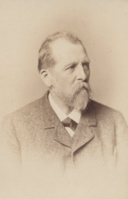
- Emil Winkler (1835–1888), engineer
- Lothar Schneider (born 1943), cartoonist
- Robert Zickert (born 1990), footballer
Other personalities associated with the city
- Steffen Blochwitz (born 1967), cyclist
References
- "Bevölkerung im Land Brandenburg nach amtsfreien Gemeinden, Ämtern und Gemeinden 31. Dezember 2018". Amt für Statistik Berlin-Brandenburg (in German). July 2019.
- Detailed data sources are to be found in the Wikimedia Commons.Population Projection Brandenburg at Wikimedia Commons
Towns and municipalities in Elbe-Elster | ||
|---|---|---|
| Coat of Arms of Elbe-Elster district | |
| Authority control |
|
|---|