Feres, Evros
Feres (Greek: Φέρες) is a town and a former municipality in the Evros regional unit, East Macedonia and Thrace, Greece. Since the 2011 local government reform it is part of the municipality Alexandroupoli, of which it is a municipal unit.[2] The municipal unit has an area of 411.160 km2.[3] Population 8,551 (2011). Feres is linked with the GR-2 or the Egnatia Odos (Alexandroupoli - Kavala - Thessaloniki - Kozani - Igoumenitsa) and the GR-51 (Alexandroupoli - Orestiada - Ormenio. The Evros river along with Turkey is to the east and also includes the entire delta to the south.
Feres Φέρες | |
|---|---|
 Feres Location within the regional unit 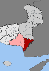 | |
| Coordinates: 40°52′N 26°10′E | |
| Country | Greece |
| Administrative region | East Macedonia and Thrace |
| Regional unit | Evros |
| Municipality | Alexandroupoli |
| Municipality established | 1986 |
| • Municipal unit | 411.2 km2 (158.8 sq mi) |
| Elevation | 43 m (141 ft) |
| Population (2011)[1] | |
| • Municipal unit | 8,551 |
| • Municipal unit density | 21/km2 (54/sq mi) |
| Community | |
| • Population | 5,659 (2011) |
| Time zone | UTC+2 (EET) |
| • Summer (DST) | UTC+3 (EEST) |
| Postal code | 685 00 |
| Vehicle registration | EB |
| Website | www.feres.gr www.evrosferes.gr |
Feres was founded in the 11th century by the Byzantine Greek emperor Isaac I Komnenos. Like the rest of the Greek mainland, it was conquered by the Ottoman Empire in the Middle Ages, until it was taken by Bulgaria in 1913 following Balkan Wars of 1912 and 1913. In 1920, as a result of the Treaty of Neuilly and subsequent agreements, the town was given to Greece.
The municipality was created in 1986 and included the settlements of Ardanio, Doriskos, Feres, Kavisos, Monastiraki and Poros. Under the Capodistrian Plan (2539/1997) in 1997, the old communities of Peplos, Pylaia and Tryfilli joined the municipality.[4]
Subdivisions
The municipal unit Feres is subdivided into the following communities (constituent villages in brackets):
Population
| Year | Village population | Municipality population |
|---|---|---|
| 1981 | 5,309 | - |
| 1991 | 4,657 | - |
| 2001 | 5,206 | 9,839 |
| 2011 | 5,457 | 8,551 |
Notable people
- Lefteris Hapsiadis (b. 1953), lyrical person
- Giorgos Valavanidis ( b. 1974), former mum
Gallery
 Church of the Monastery of Theotokos Kosmosoteira
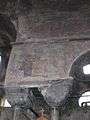 Surviving art in the church
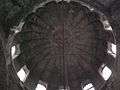 Interior of the church dome
 Church interior
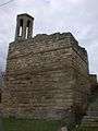 Tower near the church
 View over Feres from the tower
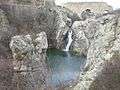 Waterfall and pool
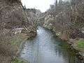 River leading from the waterfall
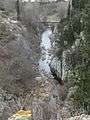 Waterfall close to centre of Feres
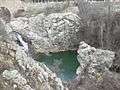 View of waterfall and pool
 Old bridge close to the waterfall
References
- "Απογραφή Πληθυσμού - Κατοικιών 2011. ΜΟΝΙΜΟΣ Πληθυσμός" (in Greek). Hellenic Statistical Authority.
- Kallikratis law Greece Ministry of Interior (in Greek)
- "Population & housing census 2001 (incl. area and average elevation)" (PDF) (in Greek). National Statistical Service of Greece. Archived from the original (PDF) on 2015-09-21.
- "EETAA local government changes". Retrieved 26 June 2020.
External links
| Wikimedia Commons has media related to Feres. |
Places adjacent to Feres, Evros | ||||||||||
|---|---|---|---|---|---|---|---|---|---|---|
| ||||||||||