Farm to Market Road 4
Farm to Market Road 4, Farm Road 4, or FM 4 is a Texas state road that runs from Grandview north and west to Jacksboro. FM 4 was designated in March 1942. FM 4 is, as of 2012, one of the longest Farm to Market Roads in the state of Texas.
| ||||
|---|---|---|---|---|
| ||||
| Route information | ||||
| Length | 116.189 mi[1] (186.988 km) | |||
| Existed | March 26, 1942[1]–present | |||
| Major junctions | ||||
| South end | ||||
| ||||
| North end | ||||
| Location | ||||
| Counties | Johnson, Hood, Palo Pinto, Jack | |||
| Highway system | ||||
| ||||

Route Description
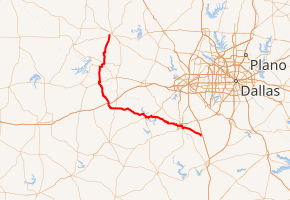
FM 4 begins at its southern terminus with Texas State Highway 81, in Grandview. FM 4 then proceeds through Grandview, and passes the Grandview Cemetery. FM 4 passes several small communities and several large farms before reaching the city of Cleburne. It passes through the Rose Hill Cemetery, before concurring with Texas State Highway 171/Texas State Highway 174. FM 4 then passes through downtown Cleburne, before reaching the end of the concurrency, just north of downtown. FM 4 then passes several small neighborhoods, and Cleburne Municipal Airport, before exiting Cleburne at its junction with US 67.[2]
FM 4 then proceeds through rolling, hilly farmland of North Texas, passing a few small communities and concurring and intersecting with several other farm roads and county roads. FM 4 then proceeds through Acton, before passing through Granbury, Lipan, Santo, Palo Pinto, and reaching its northern terminus at Jacksboro.[2]
History
The route was designated on March 26, 1942 between Santo and U.S. Highway 80, replacing Spur 40.[3] The route was extended north to the end of FM 130 in Lone Camp on July 11, 1945. The route was extended to U.S. Highway 180 on September 6, 1945, replacing FM 130. The route was extended southeast to Granbury on October 23, 1949, replacing FM 7. On February 6, 1953, the route had been extended north to a road intersection south of the Brazos River, replacing FM 1193. On October 7, 1955, the route had been extended north across the river to Graford, replacing FM 1194. On December 20, 1984, when the district combined several farm to market roads with other ones, FM 4 was extended north to Jacksboro, replacing FM 206.[4] On February 25, 1985, an amendment to the previous request, FM 4 extended south to then U.S. Highway 81 (now SH 81) at Grandview, replacing FM 208[5] and FM 110.[6]
The Honda Sport Touring Association has named the section between Palo Pinto and Granbury, through the Palo Pinto Mountains, one of Texas' top ten roads for riding enjoyment and scenery.[7]
Major intersections
| County | Location | mi[2] | km | Destinations | Notes |
|---|---|---|---|---|---|
| Johnson | Grandview | 0.0 | 0.0 | Southern terminus; Southern end of FM 916 concurrency | |
| | 1.0 | 1.6 | Northern end of FM 916 concurrency | ||
| | 9.5 | 15.3 | |||
| Cleburne | 12.0 | 19.3 | |||
| 12.7 | 20.4 | ||||
| 13.6 | 21.9 | Southern end of SH 171/SH 174 concurrency | |||
| 14.1 | 22.7 | ||||
| 14.1 | 22.7 | Access to Texas Health Harris Methodist Hospital Cleburne | |||
| 15.7 | 25.3 | Northern end of SH 171/SH 174 concurrency | |||
| 18.7 | 30.1 | Interchange | |||
| | 25.5 | 41.0 | Southern end of FM 2331 concurrency | ||
| | 26.3 | 42.3 | Northern end of FM 2331 concurrency | ||
| Hood | Acton | 35.5 | 57.1 | Southern end of FM 167 concurrency | |
| 36.1 | 58.1 | Northern end of FM 167 concurrency | |||
| Granbury | 38.9 | 62.6 | Eastern end of US 377 concurrency | ||
| 40.9 | 65.8 | Western end of US 377 concurrency | |||
| 41.2 | 66.3 | Eastern end of US 377 Bus. concurrency | |||
| 42.6 | 68.6 | Western end of US 377 Bus. concurrency | |||
| 42.6 | 68.6 | Southern end of FM 51 concurrency | |||
| 43.1 | 69.4 | Northern end of FM 51 concurrency | |||
| Thorp Spring | 46.4 | 74.7 | |||
| | 57.1 | 91.9 | |||
| Lipan | 61 | 98 | Eastern end of FM 1189 concurrency | ||
| 61.2 | 98.5 | Western end of FM 1189 concurrency | |||
| Palo Pinto | | 65.9 | 106.1 | ||
| | 68.9 | 110.9 | |||
| | 72.4 | 116.5 | I-20 exit 380 | ||
| Santo | 75.1 | 120.9 | |||
| 75.4 | 121.3 | ||||
| | 81.5 | 131.2 | |||
| Palo Pinto | 89.1 | 143.4 | Western end of US 180 concurrency | ||
| 89.6 | 144.2 | Eastern end of US 180 concurrency | |||
| | 102.5 | 165.0 | Western end of SH 254 concurrency | ||
| Graford | 103.3 | 166.2 | |||
| 104.0 | 167.4 | Eastern end of SH 254 concurrency | |||
| 104.1 | 167.5 | ||||
| Jack | | 114.0 | 183.5 | ||
| Jacksboro | 124.6 | 200.5 | Northern terminus | ||
| 1.000 mi = 1.609 km; 1.000 km = 0.621 mi | |||||
Note that the total mileage when listed by junctions does not agree with the total mileage certified by the Texas Department of Transportation because the number given by TxDOT does not include concurrencies.
References
- Transportation Planning and Programming Division (n.d.). "Farm to Market Road No. 4". Highway Designation Files. Texas Department of Transportation. Retrieved 2008-08-25.
- Overview Map of Farm to Market Road 4 Distances Between Intersections (Map). Google Maps.
- "State Highway Loop No. 40". Archived from the original on 2012-10-13. Retrieved 2011-08-14.
- "Farm to Market Road No. 206". Archived from the original on 2011-05-26. Retrieved 2010-04-05.
- "Farm to Market Road No. 208". Archived from the original on 2011-05-26. Retrieved 2010-04-05.
- "Farm to Market Road No. 110". Archived from the original on 2011-05-26. Retrieved 2010-04-05.
- "Texas' Top Ten Roads". Retrieved 2008-08-23.