Explorer 22
Explorer 22 (known as S-66 pre-launch; also called BE-2 or Beacon Explorer B) was a small American ionospheric research satellite launched October 9, 1964, part of NASA's Explorers Program. It was instrumented with an electrostatic probe, four radio beacons for ionospheric research, a passive laser tracking reflector, and two radio beacons for Doppler navigation experiments. Its objective was to provide enhanced geodetic measurements of the Earth as well as data on the total electron content in the Earth's atmosphere and in the satellite's immediate vicinity.
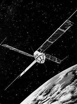 Image of Explorer 27 (same configuration as Explorer 22). | |
| Mission type | Earth science |
|---|---|
| Operator | NASA |
| COSPAR ID | 1964-064A[1] |
| SATCAT no. | 899 |
| Mission duration | 5 years and 4 months |
| Spacecraft properties | |
| Manufacturer | Applied Physics Laboratory |
| Launch mass | 52.6 kg (116 lb) |
| Start of mission | |
| Launch date | 10 October 1964, 03:01 UTC[2] |
| Rocket | Scout X-4 |
| Launch site | Vandenberg PALC-D[3] |
| End of mission | |
| Last contact | February 1970 |
| Orbital parameters | |
| Reference system | Geocentric |
| Regime | Low Earth |
| Eccentricity | 0.0130[1] |
| Perigee altitude | 889 km (552 mi) |
| Apogee altitude | 1,076 km (669 mi) |
| Inclination | 79.7° |
| Period | 104.7 minutes |
| Epoch | 10 October 1964 |
Explorers | |
Spacecraft design
Built at the Applied Physics Laboratory[5] under the direction of Goddard Space Flight Center (Project Manager F. T. Martin),[4] Explorer 22 began as "S-66", the last of the five satellites in NASA's first stage of ionospheric exploration, and the first of five NASA geodetic satellites.[6]:346 Its primary mission was "to conduct ionospheric measurements on a worldwide basis. The program will determine the total electron content of a vertical cross-section of the ionosphere located between the satellite and the earth. Accomplishing this objective will aid in establishing the behavior pattern of the ionosphere as a function of latitude, time of day, season, and solar cycle."[4]
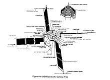
Weighing 130 pounds (59 kg), the satellite was an octagonal spacecraft with a honeycomb nylon and fiberglass hull, 18 inches (46 cm) in diameter, 12 inches (30 cm) high, with four solar panels 10 inches (25 cm) wide and 66 inches (168 cm) long.[4]
A three-axis magnetometer and sun sensors provided information on the satellite attitude and spin rate.[7] There was no tape recorder aboard so data could be received only when the satellite was within range of a ground telemetry station. Continuous Doppler transmitters operated at 162 and 324 MHz to permit precise tracking by Transit tracking stations for navigation and geodetic studies.[1] Four other transmitters operated on 20, 40, 41, and 360 MHz to measure ionospheric density. S-66's last experiment was an Electron Density Experiment designed for measuring charged particles in the immediate vicinity of the satellite.[4]
S-66 mounted 360 one-inch "cube corner" reflectors made of fused silica[4] so that the satellite could be tracked via lasers beamed from mobile stations at Goddard's Wallops Island facility[6]:346[8] and other facilities.
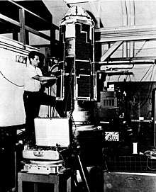
The first S-66 had been constructed by March 1963, when a comprehensive series of environmental tests was begun to ensure the satellite could withstand the harsh conditions of space. There were two rounds of tests, occurring March–April and July–August 1963.[4]
Mission
The first S-66 was scheduled for launch in late 1963. However, due to problems with the Scout X-4,[4] the flight was rescheduled for the following year on a Delta booster, from Cape Canaveral's Launch Complex 17A.[2] On March 19, 1964, the first attempt to this S-66 ended in failure when the third stage of its Delta rocket burned just 22 seconds instead of the programmed 40. This was only the second time the Delta booster had failed, and the incident followed 22 prior successes.[6]:109
A second S-66 was launched, this time successfully, via a Scout X-4 rocket at 03:01 UT, October 9, 1964, from the PALC-D launch facility at Vandenberg Air Force Base. Once in space, it became known as Explorer 22.[2] Explorer 22 had a nearly polar orbit, inclined 79.7° to the equator, with an initial apogee of 1,076 kilometers (669 mi) and perigee of 884 kilometers (549 mi), and a period of 104.7 minutes.[4] The satellite was initially spin-stabilized, but it was despun after solar paddle erection. About 48 hours later, the satellite's axis of symmetry was oriented with the local magnetic field by means of a strong bar magnet and damping rods.[9]
During the first 48 hours of flight, internal temperatures were at the top of the satellite's tolerance. As a result, the two Doppler transmitters (162 MHz and 324 MHz) were kept off during the periods that the spacecraft was 100% illuminated by the sun.[4]
Mission results
Explorer 22 involved the largest international participation to date in a NASA mission: some 50 scientific groups in 32 countries ran more than 80 ground tracking stations.[6]:346 Satellite laser ranging (SLR) began shortly after the satellite's magnetic stabilization, during the satellite's daily flyovers. This allowed highly accurate measurements of Explorer 22's orbit, making it possible for the irregularities of the Earth's shape and density to be more accurately mapped. Dr. Henry Plotkin managed this ongoing experiment.[9] Explorer 22's Project Scientist was Robert Bordeau.[5]
In August 1968, data acquisition from the Explorer 22's telemetry channels was discontinued. In July 1969, tracking and world map production were discontinued by Goddard, and world map production based on NORAD orbit elements was subsequently assumed by ESRO. The satellite failed in February 1970 and Explorer 22's successor, Explorer 27, was turned on in order to continue the satellite's beacon experiment.[10]
See also
References
- "BE-B". NSSDC Master Catalog. NASA Goddard Space Flight Center.

- "Launch Log". Jonathan's Space Page. Retrieved June 9, 2018.
- "Letter dated 22 December 1964 from the Permanent Representative of the United States of America addressed to the Secretary-General". UNOOSA. 30 December 1964. Retrieved June 9, 2018.
- "Environmental test program of the beacon explorer spacecraft" (PDF). NASA Goddard Space Flight Center; Greenbelt, MD, United States. Retrieved October 23, 2019.
- Harvey, Brian (24 November 2017). Discovering the Cosmos with Small Spacecraft: The American Explorer Program. Springer. pp. 91–. ISBN 978-3-319-68140-5.
- "Astronautics and Aeronautics, 1964" (PDF). NASA, Scientific and Technical Division. Retrieved October 23, 2019.
- Ludwig Combrinck, 2010. Sciences of Geodesy (Cap. 9). Springer-Verlag. Retrieved June 9, 2018.
- "Goddard laser systems and their accuracies". Philosophical Transactions of the Royal Society. London: McGraw Hill Publishing Company: 443–444. 1977. Retrieved October 21, 2019.
- "NASA Testing Laser Satellite Techniques". Aviation Week and Space Technology. New York: McGraw Hill Publishing Company. November 2, 1964. p. 55. Retrieved November 2, 2019.
- Wade, Mark. "Beacon". Encyclopedia Astronautica. Retrieved June 9, 2018.