Exclusive economic zone of Vietnam
Vietnam claims an exclusive economic zone (EEZ) of 417,663 km2 (161,261 sq mi) with 200 nautical miles (370.4 km; 230.2 mi) from its shores.[1]

Vietnam has the 33rd longest coastline of 3,260 km (2,030 mi).[3] It includes much of the western area of the South China Sea and parts of the southern area bordering Malaysia and Brunei's EEZs. The total land area, including inland bodies of water, of Vietnam is 331,212 km2 (127,882 sq mi).[n 1] It has dozens of islands. Phú Quốc is the largest island with 574 square kilometres (222 sq mi).[4]
Disputes
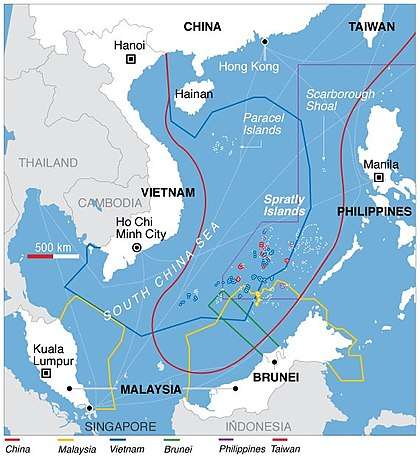
Vietnam’s disputes are mainly with the People's Republic of China. Vietnam rejects China's Nine-Dash Line which extends much further than China's 200 nautical miles (370.4 km; 230.2 mi) from its shores. The Nine-Dash line cuts straight through Vietnam's Exclusive Economic Zone in the South China Sea and would reduce Vietnam's EEZ by 3/4th. This line also cuts the EEZ of the Philippines and Malaysia in half. Brunei would lose 90% of its EEZ. According to former Philippine President Benigno Aquino III, "China's nine-dash line territorial claim over the entire South China Sea is against international laws, particularly the United Nations Convention of the Laws of the Sea (UNCLOS)".[5] Vietnam also rejected the Chinese claim, citing that it is baseless and against the UNCLOS.[6]
In the spring of 2014, China and Vietnam clashed over China's Haiyang Shiyou oil rig in Vietnam's EEZ. The incident left seventeen Vietnamese injured and damaged both China's and Vietnam's ships.[7]
Paracel and Spratly Islands
The Paracel Islands and Spratly Islands are historically part of Vietnam. The Geneva Accords of 1954,[8] which ended the First Indochina War, gave South Vietnam control of the Vietnamese territories south of the 17th Parallel, which included the islands in the Paracels and Spratlys.[9]
In 1974, during the Vietnam War, the PRC used military force in the Paracel Islands and took Yagong Island and the Crescent group of reefs from South Vietnam.[10][11] Since the 1990s China still occupies and controls all of the Paracel Islands. The PRC controls all of the features in the Paracels.
Vietnam controls 29 features of the Spratly Islands. However, since 2013 China has been constructing artificial islands on reefs and military bases which changed the balance of power in favour of the PRC in the South China Sea.[12]
References
- Exclusive Economic Zones – Sea Around Us Project – Fisheries, Ecosystems & Biodiversity – Data and Visualization.
- https://www.marineregions.org/eezdetails.php?mrgid=8484 Marineregions.org
- CIA World Factbook: Coastline
- Boobbyer, Claire; Spooner, Andrew (2013). Vietnam, Cambodia & Laos Footprint Handbook. Footprint Travel Guides. p. 173. ISBN 978-1-907263-64-4.CS1 maint: ref=harv (link)
- Bengco, Regina (2 June 2011). "Aquino mulls UN protest on Spratlys". Maritime Security Asia. Archived from the original on 14 January 2013.
- Hoang Viet (19 May 2009). "Is the Ox's tongue line legal?". BBC.
- Bui, Nhung T. (4 July 2016). "Managing anti-China nationalism in Vietnam: evidence from the media during the 2014 oil rig crisis". The Pacific Review. 0 (2): 169–187. doi:10.1080/09512748.2016.1201132. ISSN 0951-2748.
- "Declaration by the Government of the French Republic". Retrieved 30 May 2019.
- Nguyen, Hong Thao (2012). "Vietnam's Position on the Sovereignty over the Paracels & the Spratlys: Its Maritime Claim". Journal of East Asia International Law. 1.
- Samuels, Marwyn (2013). Contest For the South China Sea. London: Routledge. pp. 55–65.
- Yoshihara, Toshi (2016). "The 1974 Paracels Sea Battle: A Campaign Appraisal". Naval War College Review. 69 (2): 41–65.
- "China Island Tracker". Asia Maritime Transparency Initiative. Retrieved 30 May 2019.