European Geostationary Navigation Overlay Service
The European Geostationary Navigation Overlay Service (EGNOS) is a satellite based augmentation system (SBAS) developed by the European Space Agency and EUROCONTROL on behalf of the European Commission. Currently, it supplements the GPS by reporting on the reliability and accuracy of their positioning data and sending out corrections. The system will supplement Galileo in a future version.
| Operator(s) | GSA, ESA |
|---|---|
| Type | Augmentation |
| Status | Operational |
| Coverage | Europe |

EGNOS consists of a network of about 40 ground stations and 3 geostationary satellites. Ground stations determine accuracy data of the satellite navigation systems and transfer it to the geostationary satellites; users may freely obtain this data from those satellites using an EGNOS-enabled receiver, or over the Internet. One main use of the system is in aviation.
According to specifications, horizontal position accuracy when using EGNOS-provided corrections should be better than seven metres. In practice, the horizontal position accuracy is at the metre level.
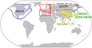
Similar service is provided in North America by the Wide Area Augmentation System (WAAS), and in Asia, by Japan's Multi-functional Satellite Augmentation System (MSAS) and India's GPS Aided GEO Augmented Navigation (GAGAN).
History and roadmap
The system started its initial operations in July 2005, with accuracy better than two metres and availability above 99%. As of July 2005, EGNOS has been broadcasting a continuous signal, and at the end of July 2005 the system was again used to track cyclists in the Tour de France road race.[1]
In 2009, the European Commission announced it had signed a contract with the company European Satellite Services Provider to run EGNOS. The official start of operations was announced by the European Commission on 1 October 2009.[2] The system was certified for use in safety of life applications in March 2011.[3] An EGNOS Data Access Service became available in July 2012.
Initial work to extend EGNOS coverage to the Southern Africa region is being done under a project called ESESA - EGNOS Service Extension to South Africa.[4]
The European Commission is defining the roadmap for the evolution of the EGNOS mission. This roadmap should cope with legacy and new missions:[5]
- 2011–2030: En-route / NPA / APV1 / LPV200 service based on augmentation of GPS L1 only. The Safety Of Life (SoL) will be guaranteed up to 2030 in compliance with ICAO SBAS SARPS.
- 2020+: It is planned that EGNOS will experiment with a major evolution by 2020, EGNOS V3, including the fulfilment of the SBAS L1/L5 standard, expansion to dual-frequency, and evolution toward a multi-constellation concept.
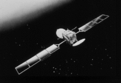
Satellites and SISNeT
| Satellite Name & Details | NMEA / PRN | Signals | Location | Status[6] |
|---|---|---|---|---|
| Inmarsat 3-F2 (Atlantic Ocean Region-East[7]) | NMEA #33 / PRN #120 | L1 | 15.5°W | retired |
| ARTEMIS [8] | NMEA #37 / PRN #124 | - | 21.5°E | retired |
| Inmarsat 4-F2 (Europe Middle East Africa[9]) | NMEA #39 / PRN #126 | - | 64°E | testing |
| Inmarsat 3-F1 (Indian Ocean[10]) | NMEA #44 / PRN #131 | - | 64.5°E | retired |
| SES-5 (a.k.a. Sirius 5 or Astra 4B) [11][12] | NMEA #49 / PRN #136[13] | L1 & L5 | 5.0°E | active |
| Astra 5B[11][12] | NMEA #36 / PRN #123[13] | L1 & L5 | 31.5°E | active |
| Eutelsat 5 West B | 5°W | launched in October 2019, it will use EGNOS 3 |
Similar to WAAS, EGNOS is mostly designed for aviation users who enjoy unperturbed reception of direct signals from geostationary satellites up to very high latitudes. The use of EGNOS on the ground, especially in urban areas, is limited due to relatively low elevation of geostationary satellites: about 30° above horizon in central Europe and much less in the North of Europe. To address this problem, ESA released in 2002 SISNeT,[14][15] an Internet service designed for continuous delivery of EGNOS signals to ground users. The first experimental SISNeT receiver was created by the Finnish Geodetic Institute.[16] The commercial SISNeT receivers have been developed by Septentrio. PRN #136 was placed into the Operational Platform from 23/08/2018 at 10:00 UTC and PRN #120 was placed into Test Platform from 30/08/2018 at 13:00 UTC.[17]
Ground stations
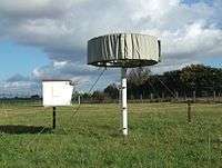
More than 40 ground stations are linked together to create EGNOS network which consists:
- 40 ranging and integrity monitoring stations (RIMS): receiving signals from US GPS satellites,
- 4 mission control centers (MCC): data processing and differential corrections counting,
- 6 navigation land earth stations (NLES): accuracy and reliability data sending to three geostationary satellite transponders to allow end-user devices to receive them.
Aviation
In March 2011, the EGNOS Safety-of-Life Service was deemed acceptable for use in aviation. This allows pilots throughout Europe to use the EGNOS system as a form of positioning during an approach, and allows pilots to land the aircraft in IMC using a GPS approach. [18]
As of September 2018 LPV (Localizer performance with vertical guidance) landing procedures, which are EGNOS-enabled, were available at more than 180 airports across Europe.[19]
References
- "What is EGNOS?". ESA. 2 August 2013. Retrieved 31 January 2016.
- "EGNOS 'Open Service' available: a new era for European navigation begins today". ESA. 1 October 2009. Retrieved 31 January 2016.
- "EGNOS navigation system begins serving Europe's aircraft". ESA. 2 March 2011. Retrieved 31 January 2016.
- "What is ESESA?". ESESA. Retrieved 31 January 2016.
- "EGNOS Future and Evolutions". ESA / NAVIPEDIA. 16 October 2015. Retrieved 31 January 2016.
- "REALTIME | Egnos User Support". ESSP-SAS. Retrieved 31 January 2016.
- "Inmarsat 3-F2". NSSDCA Master Catalog. NASA.
- "Artemis". NSSDCA Master Catalog. NASA.
- "Inmarsat 4-F2". NSSDCA Master Catalog. NASA.
- "Inmarsat 3-F1". NSSDCA Master Catalog. NASA.
- "EGNOS Case Study". SES. Archived from the original on 2009-05-28.
- Beyond Frontiers Broadgate Publications (September 2016) pp97
- "The Almanac". Retrieved 2015-10-01.
- "Signal-in-Space through the Internet". ESA. 19 September 2002. Retrieved 31 January 2016.
- "SISNeT - related publications". ESA. Retrieved 31 January 2016.
- "Navigate via the web with the SISNeT receiver". ESA. 6 September 2002. Retrieved 31 January 2016.
- "Satellite navigation receiver uses EGNOS signals delivered via Internet". ESA. 25 October 2005. Retrieved 31 January 2016.
- http://www.esa.int/Our_Activities/Navigation/The_present_-_EGNOS/What_is_EGNOS
- "Precision EGNOS satnav sparking quiet revolution in aircraft landings". European Space Agency. 4 September 2018. Retrieved 3 May 2020.
External links
- European Commission information on EGNOS
- Website of the EGNOS operator ESSP SaS
- EGNOS Operations User Support
- ESA information on EGNOS
- The EGNOS book, ESA Publications, Javier Ventura-Traveset and Didier Flament
- European Space Agency information on EGNOS for Professionals
- Learning EGNOS
- ESESA - EGNOS Service Extension to South Africa
- Usman A Zahidi, "EGNOS enabled GPS Software Receiver" Report Page,
- Information on WAAS, EGNOS & MSAS
- Navipedia information on EGNOS—Wiki initiated by the European Space Agency
| |||||||||||||||
| |||||||||||||||
| Telecommunications |
| ||||||||||||||
Technology demonstrators | |||||||||||||||
| Cancelled and proposed |
| ||||||||||||||
| Failed | |||||||||||||||