Enfield, New South Wales
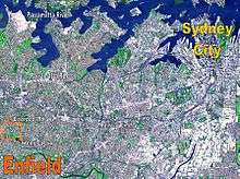
Enfield is a suburb in the Inner West[2] of Sydney, in the state of New South Wales, Australia. It is 11 kilometres south-west of the Sydney central business district in the local government area of Municipality of Burwood.
| Enfield Sydney, New South Wales | |||||||||||||||
|---|---|---|---|---|---|---|---|---|---|---|---|---|---|---|---|
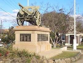 War Memorial, Liverpool Road | |||||||||||||||
| Population | 2,833 (2016 census)[1] | ||||||||||||||
| Postcode(s) | 2136 | ||||||||||||||
| Location | 11 km (7 mi) from Sydney CBD | ||||||||||||||
| LGA(s) | Municipality of Burwood | ||||||||||||||
| State electorate(s) | Strathfield | ||||||||||||||
| Federal Division(s) | Watson | ||||||||||||||
| |||||||||||||||
History
The suburb is named after Enfield Town, a suburb of London, England.
Aboriginal culture
Before the arrival of the First Fleet in 1788, the Enfield area belonged to the Wangal people, a clan of the Eora tribe, which covered most of Sydney. In the early years, the Eora people were badly affected by smallpox, which arrived with the British. Many of the clans became unsustainably small and the survivors formed new bands who lived where they could. While it would be wrong to say that the local indigenous population gave no resistance to British land claims (Pemulwuy being a notable example), within thirty years or so of the colony's establishment, most of the land in the inner-west had been conceded to British settlers.
European settlement
William Faithful was granted 100 acres (40 hectares) in 1810 covering what is now Enfield as well as much of Croydon Park and parts of Burwood and Croydon. In 1812, Liverpool Road was built through Faithful's land and the high position of Enfield made it a sensible spot for a staging post along the road. By the mid-1840s a small village had formed and the surrounding area supported vegetable gardening and a timber industry. St Thomas' Anglican Church was built in 1848 and is the oldest surviving building in the suburb.[3]
In 1853, a post office was built. This was the first recorded use of the name Enfield for the area although it may already have been unofficially known as that. In 1889, Enfield was deemed large enough to have its own municipal council which covered a larger area than the current suburb including those parts of the current Burwood and Strathfield councils south of Liverpool Rd. In 1891, its municipal population of 2,050 was larger than that of neighbouring Strathfield (1,850) and only just smaller than another neighbour Canterbury (2,426). Enfield retained its separate identity until 1949 when the NSW state government decided to abolish a number of small local councils by amalgamating them with their neighbours.[4] Thus Enfield was absorbed into Burwood and Strathfield.[5]
Enfield Olympic Pool, located in Henley Park is the oldest freshwater pool in Sydney, completed in 1933 and officially opened by Bertram Stevens, NSW Premier and Colonial Treasurer, on 18 November 1933.
The Enfield War Memorial is situated on the corner of Liverpool Road and Coronation Parade on the lawn outside the former Enfield Council Chambers. The memorial is a rectangular sandstone pedestal with four marble plaque panels with the engraved names of the men and women who served during World War I. The top of the pedestal displays a 105mm French Howitzer gun that was donated to the Australian Government by the French government as recognition of Australia's wartime assistance during World War I. The Memorial was unveiled on 11 October 1924 by the NSW Attorney-General and later by the Premier of NSW from 1927-1930. Erection of the memorial was made possible by Mayor and Mayoress of Enfield, Mr and Mrs Ebenezer Ford. The wheel treads of the French howitzer gun which are made of wood are still intact.[6]
Enfield tram lines
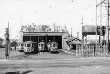
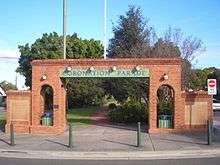
The Enfield system began as a steam tramway opening in 1891 between Ashfield Station and Enfield and was a separate group of lines that worked independently from the main Sydney network. The lines were based around a depot in Enfield. The green patch of grass that covers most of Coronation Parade lies on top of the original tram tracks that led, in a straight line, directly north onto the Boulevarde along a route that led originally from Ashfield. In 1901, this line was extended north to Mortlake, and in 1909 a branch to Cabarita Park was opened. The system was electrified in 1912.[7]
Services operated from Ashfield Station along Liverpool Road, Georges River Road and Tangarra Street, then north along Coronation Parade in a straight line passing what is now the Enfield War Memorial and back to Liverpool Road through Enfield, and then north along Burwood Road through Burwood. The line then turned into Crane Street, then Majors Bay Road and Brewer Street to Cabarita Junction.[8]
The line was double track until this point, it then split into single-track branches to Mortlake and Cabarita. Short services were turned back at Brighton Avenue, Plymouth Street, Enfield, Burwood Station and Wellbank St.
Services operated every five minutes between Ashfield and Wellbank St in peak periods, and every 15 minutes (30 minutes at off-peak times) on the two branches. A depot on Tangarra Street[9] served the lines. The lines closed in 1948, and were replaced by buses.
The road that is now used for motor traffic on Coronation Parade was the road that was built beside the original tram track until the main intersection where the road was then built over the tracks became the Boulevarde. The Coronation Parade arch that leads into the former Coronation Parade tram station displays 4 light bulbs which were originally the holders for the four electricity cables that ran along the old tram line.
Churches
St Joseph's Catholic Church on Liverpool Road was built 1930-31.[10] The church was designed by architect Clement Glancy in Inter-War Academic Classical style inspired by Église de la Madeleine, Paris.
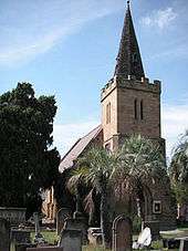
St Thomas's Anglican Church, Coronation Parade was built in 1848 in a Gothic Revival style and is now listed on the Register of the National Estate;[11]
Commercial area
Enfield has a small commercial area along Liverpool Road centred on the intersection with Coronation Parade and The Boulevarde. It is close to the larger commercial areas of Burwood and Strathfield. Enfield itself is actually quite small in area being bounded by Liverpool Road, Coronation Parade, Mitchell Street and Burwood Road.
Schools
Enfield Public School is on Beaumaris Street. St Joseph's Primary School is located on the corner of Burwood and Liverpool Roads and is a Catholic school for kindergarten to Year 6.
Transport
Liverpool Road intersects with Coronation Parade and The Boulevarde at Enfield.
Transit Systems operates six bus services through Enfield:
- 420 from Burwood to Westfield Eastgardens via Enfield, Campsie and Sydney Airport [12]
- 420N from Burwood to Westfield Eastgardens via Enfield, Campsie and Sydney Airport - Night service[13]
- 464 from Ashfield to Mortlake via Enfield and Burwood [14]
- 466 from Ashfield to Cabarita via Enfield, Burwood and Bayview Park[15]
- 480 & 483 from the City (Domain) to Strathfield via Enfield [16][17]
Transdev NSW operates three services:
- 913 from Bankstown to Strathfield via Enfield [18]
- 914 from Greenacre to Strathfield via Enfield [19]
- M90 Liverpool - Burwood [20]
Punchbowl Bus Company operates route 450, from Hurstville to Strathfield via Lakemba and Enfield.[21]
Prior to the 1960s, there was a tramline which ran from Ashfield to Mortlake and Cabarita via Enfield and Burwood following the route of the modern day 464 & 466 bus services.
People
Demographics
In the 2016 Census, there were 2,833 people in Enfield. 49.6% of people were born in Australia. The next most common countries of birth were China 10.3% and South Korea 3.9%. 40.0% of people spoke only English at home. Other languages spoken at home included Mandarin 10.2%, Cantonese 6.9%, Arabic 6.1%, Italian 6.0% and Korean 5.1%. The most common responses for religion were Catholic 35.8% and No Religion 22.2%.[1]
Notable residents
- Harold Burfield Taylor (1890–1966): chemist and army officer.
- James Anderson (1894–1973): tennis player, Australian Open men's singles champion in 1922, 1924 & 1925.
- Andrew Chan (1984–2015); executed drug trafficker and co-ringleader of the Bali Nine[22]
- Gerry Hazlitt (1888–1915): Australian test cricketer (9 tests).
- Norman 'Wizard' Smith (1890–1958): racing car driver and holder of the Australian land speed record in the 1930s.[23]
- Bob Windle (1944-): Australian swimmer, won the Olympic 1500 metre freestyle gold medal at Tokyo in 1964.
- Bob Norton OBE (1922-1992) : a former president of the Royal Australasian College of Dental Surgeons lived in Enfield as a school student.[24]
Other places of interest
- Enfield Aquatic Centre (Enfield Olympic Swimming Pool) is a council-run swimming pool located in Portland Street. It was opened in 1933 and is the oldest freshwater swimming pool in Sydney.
- The Royal Society for the Blind has a centre – operating as Vision Australia, in Mitchell Street[25]
References
- Australian Bureau of Statistics (27 June 2017). "Enfield (State Suburb)". 2016 Census QuickStats. Retrieved 11 April 2018.

- Australian Suburb Guide: Sydney Inner West Archived 26 December 2012 at the Wayback Machine Retrieved 8 August 2013.
- Book of Sydney Suburbs, Frances Pollon (Angus and Robertson) 1990, p.96
- "Archived copy". Archived from the original on 18 October 2009. Retrieved 5 March 2010.CS1 maint: archived copy as title (link)
- burwood.nsw.gov Archived 27 August 2006 at the Wayback Machine
- "Archived copy". Archived from the original on 18 October 2009. Retrieved 31 January 2010.CS1 maint: archived copy as title (link)
- "Local History | Burwood Council". Burwood.nsw.gov.au. 10 February 2011. Retrieved 22 August 2013.
- Gabor Sandi. "Sydney 1947". Tundria.com. Retrieved 22 August 2013.
- "Tram Ride". Lockhart.olsen.tripod.com. Retrieved 22 August 2013.
- A Pictorial Guide to Identifying Australian Architecture, Apperly (Angus and Robertson) 1994, p.155
- The Heritage of Australia, Macmillan Company, 1981, p.2/15
- "Transit Systems route 420". Transport for NSW.
- "Transit Systems route 420N". Transport for NSW.
- "Transit Systems route 464". Transport for NSW.
- "Transit Systems route 466". Transport for NSW.
- "Transit Systems route 480". Transport for NSW.
- "Transit Systems route 483". Transport for NSW.
- "Transdev NSW route 913". Transport for NSW.
- "Transdev NSW route 914". Transport for NSW.
- "Transdev NSW route M90". Transport for NSW.
- "Punchbowl Bus Co route 450". Transport for NSW.
- Cornford, Philip (23 April 2005). "How the trap snapped shut". The Age. Melbourne. Retrieved 26 June 2011.
- http://www.adb.online.anu.edu.au/biogs/A110677b.htm
- Who's Who in Australia (Herald and Weekly Times Melb, 1988) pp 681: Norton, Robert York (1922 – )
- Vision Australia
External links
| Wikimedia Commons has media related to Enfield, New South Wales. |