Elidir Fawr
Elidir Fawr is a mountain in Snowdonia, north Wales, the northernmost peak in the Glyderau.
| Elidir Fawr | |
|---|---|
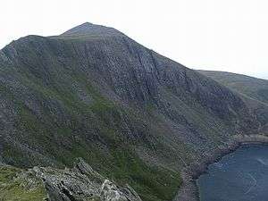 Elidir Fawr from Mynydd Perfedd with Marchlyn Mawr below | |
| Highest point | |
| Elevation | 924 m (3,031 ft) |
| Prominence | 212 m (696 ft) |
| Parent peak | Y Garn |
| Listing | Marilyn, Hewitt, Welsh 3000s, Nuttall, Furth |
| Naming | |
| Pronunciation | Welsh: [ɛˈlɪdiɾ ˈvawɾ] |
| Geography | |
| Location | Gwynedd, UK |
| Parent range | Snowdonia |
| OS grid | SH612613 |
| Topo map | OS Landranger 115 |
To the north of the summit is a small lake, Marchlyn Mawr, which is the upper reservoir for Dinorwig power station, a pump-storage power station hidden inside the mountain. Water from this lake flows through huge tunnels into the lower reservoir Llyn Peris. From the north, Elidir Fawr is very prominent, and can appear to be higher than the higher mountains behind it.
Slate quarries
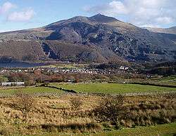
From Llanberis, the mountain is dominated by the former Dinorwic slate quarries and the waste they have left behind.
Approach
It is a reasonably short, but steep walk up to the summit, and this can be undertaken from the Deiniolen side or from Nant Peris. The Deiniolen walk provides views down to Llanberis, while the Nant Peris approach is short and quite steep.[1] The summit can also be reached from Ogwen Cottage via a traverse of Y Garn and Foel-goch. The route makes its way around the headwall of Cwm Dudodyn to Bwlch y Brecan and up to the rocky summit of Elidir Fawr.
| Listed summits of Elidir Fawr | ||||
| Name | Grid ref | Height | Status | |
|---|---|---|---|---|
| Carnedd y Filiast | SH620627 | 821 m (2,694 ft) | Hewitt, Nuttall | |
References
- Nuttall, John & Anne (1999). The Mountains of England & Wales - Volume 1: Wales (2nd edition ed.). Milnthorpe, Cumbria: Cicerone. ISBN 1-85284-304-7.