Elephant Butte Dam
Elephant Butte Dam or Elephant Butte Dike is a concrete gravity dam on the Rio Grande river near Truth or Consequences, New Mexico. The dam impounds Elephant Butte Reservoir, which is used mainly for agriculture, and also provides for recreation, hydroelectricity and flood control. The construction of the dam has reduced the flow of the Rio Grande to a small stream for most of the year, with water released only during the summer irrigation season, or during times of exceptionally heavy snow melt.
| Elephant Butte Dam | |
|---|---|
 | |
| Country | United States |
| Location | Elephant Butte, New Mexico |
| Status | In use |
| Construction began | 1911 |
| Opening date | 1916 |
| Owner(s) | U.S. Bureau of Reclamation |
| Dam and spillways | |
| Type of dam | Gravity |
| Impounds | Rio Grande |
| Height | 301 ft (92 m) |
| Length | 1,674 ft (510 m) |
| Width (crest) | 18 ft (5 m) |
| Width (base) | 228 ft (69 m) |
| Dam volume | 618,785 cu yd (473,095 m3) |
| Reservoir | |
| Creates | Elephant Butte Lake |
| Total capacity | 2,065,010 acre⋅ft (2.547152329×10⁹ m3) |
| Catchment area | 28,900 sq mi (75,000 km2) |
| Surface area | 36,500 acres (14,800 ha) |
| Power Station | |
| Hydraulic head | 140 ft (43 m) (rated) |
| Turbines | 1 x Francis turbine |
| Installed capacity | 27.95 MW |
| Annual generation | 38,449,061 kWh |
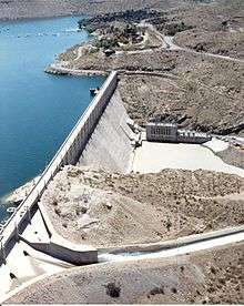
Elephant Butte Dam | |
 The spillway is in the lower left corner of the picture and the power plant is located at the base of the opposite side of the dam. | |
  | |
| Nearest city | Elephant Butte, New Mexico |
| Coordinates | 33°9′17″N 107°11′31″W |
| Area | 45 acres (18 ha) |
| Built | 1910 |
| Architect | Louis C. Hill |
| Architectural style | Gravity-type |
| NRHP reference No. | 79001556[1] |
| NMSRCP No. | 617 |
| Significant dates | |
| Added to NRHP | April 9, 1979 |
| Designated NMSRCP | March 20, 1978 |
History

The first to propose a dam for the area were Peter E. Kern, E.V. Berrien, John Campbell, R.M. Loomis and Edward Roberts.[2] They had camped in the area where the dam is now and Kern encouraged the others to consider building a dam there.[3]
The dam is part of the Rio Grande Project, a project to provide power and irrigation to south-central New Mexico and west Texas. The United States Congress authorized construction of the dam on February 25, 1905 and it began in 1911. It was completed in 1916 but allowed to begin filling in 1915.[4]
At the time of its construction, the dam was the largest irrigation dam ever built with the exception of the Aswan Dam in Egypt.[5] It was expected that the dam would become the property of the local settlers once a water tax had reimbursed the government for the cost of construction. During construction the government used a system of 3 cables, each having a capacity of 15 tons and a span of 1,400 feet (430 m).
The name "Elephant Butte" refers to a volcanic core similar to Devils Tower in Wyoming. It is now an island in the lake. The butte was said to have the shape of an elephant.

The dam was listed on the U.S. National Register of Historic Places in 1979.[1][6] Historic resources from the era of construction of the dam, and from New Deal era development of power generation and recreation facilities in the area, are recognized in the 1997 listing of a 2,443 acres (9.89 km2) area on the National Register as the Elephant Butte Historic District. The historic district listing includes the dam itself and much more.[7]
Characteristics
Elephant Butte Dam is 301 feet (91.7 m) high, 1,674 feet (510.2 m) long including the spillway and is made from 618,785 cubic yards (473,095 m³) of concrete.[4] The width at the top of the dam is 18 feet (5.5 m) and 228 feet (69.5 m) at the base.[8]
The reservoir has a capacity of 2,065,010 acre feet (2.54715×10⁹ m3) of water[4] and controls the runoff from 28,900 square miles (74,850 km²).[8] It provides irrigation to 178,000 acres (720 km²) of land. The dam also contains a 27,945-kilowatt hydroelectric powerplant. The current turbine was installed in 1940 and generates 38,449,061 kWh per year (as of 2005).[4] The crest elevation is 4390 ft (1338 m).[9]
See also

- List of Rio Grande dams and diversions
- Caballo Dam
- National Register of Historic Places listings in Sierra County, New Mexico
References
- "National Register Information System". National Register of Historic Places. National Park Service. July 9, 2010.
- "Originator of Elephant Butte Project is Here from Alaska". El Paso Herald. 31 January 1910. Retrieved 29 April 2017 – via Newspapers.com.
- Hamilton, Nancy (21 November 1974). "Papers, Photos Add to Kern Place Founder's History". El Paso Herald-Post. Retrieved 27 April 2017 – via Newspapers.com.
- "Elephant Butte Powerplant". Rio Grande Project. Bureau of Reclamation. December 28, 2005. Archived from the original on September 26, 2006. Retrieved October 11, 2006.
- "Great Elephant Butte Dam Approaching Completion". Popular Mechanics Magazine. January 1915. Retrieved 9 February 2009.
- T. Lindsay Baker; William L. Cumiford (January 27, 1978). "National Register of Historic Places Inventory/Nomination: Elephant Butte Dam and Reservoir". National Park Service. Retrieved July 5, 2019. With accompanying two photos from 1971
- David A. Phillips, Jr. (July 19, 1996). "National Register of Historic Places Registration: Elephant Butte Historic District". National Park Service. Retrieved July 4, 2019. With accompanying 29 historic and recent photos
- "Elephant Butte Dam". Dataweb. Bureau of Reclamation. August 22, 2006. Archived from the original on September 27, 2006. Retrieved October 11, 2006.
- "Elephant Butte Dike". Geographic Names Information System. United States Geological Survey. Retrieved 2006-05-12.
External links
![]()
- EBID. "Elephant Butte Irrigation District". Retrieved 1 May 2014.
| Topics | |
|---|---|
| Lists by state |
|
| Lists by insular areas | |
| Lists by associated state | |
| Other areas | |
| Related | |
| |