Elassona
Elassona (Greek: Ελασσόνα; Katharevousa: Greek: Ἐλασσών, romanized: Elasson) is a town and a municipality in the Larissa regional unit in Greece. During antiquity Elassona was called Oloösson (Ὀλοοσσών) and was a town of the Perrhaebi tribe. It is situated at the foot of Mount Olympus. Elassona is bypassed by the GR-3 (Larissa - Kozani - Florina).
Elassona Ελασσόνα | |
|---|---|
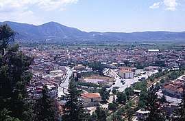 Overview of Elassona | |
 Elassona Location within the region 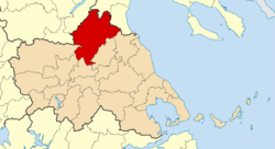 | |
| Coordinates: 39°53′N 22°11′E | |
| Country | Greece |
| Administrative region | Thessaly |
| Regional unit | Larissa |
| Area | |
| • Municipality | 1,565.2 km2 (604.3 sq mi) |
| • Municipal unit | 291.1 km2 (112.4 sq mi) |
| Elevation | 308 m (1,010 ft) |
| Population (2011)[1] | |
| • Municipality | 32,121 |
| • Municipality density | 21/km2 (53/sq mi) |
| • Municipal unit | 11,044 |
| • Municipal unit density | 38/km2 (98/sq mi) |
| Community | |
| • Population | 7,750 (2011) |
| • Area (km2) | 102.5 |
| Time zone | UTC+2 (EET) |
| • Summer (DST) | UTC+3 (EEST) |
| Postal code | 402 00 |
| Area code(s) | 2410 |
| Vehicle registration | ΡΙ |
| Website | www.elassona.com.gr |
History
Due to its location on the passes leading from the Thessalian plain to Macedonia, the site of Elassona was always of some strategic importance.[2]
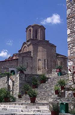
Known as Olo[ö]sson (Ὀλο[ο]σσών) in antiquity, in the early Byzantine period it was known as Lossonos, and was one of the sites refortified under Justinian I (r. 527–565).[2] the modern name first appears in the writings of the 12th-century scholar and archbishop Eustathius of Thessalonica, who considered it "barbaric".[2] At the turn of the 14th century, the Panagia Olympiotissa Monastery was founded on the hilltop citadel.[2] In 1304, Guy II de la Roche, Duke of Athens, passed through during a campaign against the Despotate of Epirus.[2]
Following the death of Stephen Gabrielopoulos in 1333, Elasson was one of the Thessalian towns (along with Stagoi, Trikala, Damasis, and Fanari) that for a short while fell under the rule of the Epirote ruler John II Orsini (r. 1323–1335).[2] Under Andronikos III Palaiologos (r. 1328–1341), privileges were granted to the Olympiotissa monastery, and the town became the seat of an archbishopric, a status it retained into the Ottoman period.[2]
Unlike the rest of Thessaly, which was annexed by Greece in 1881, Elassona remained part of the Ottoman Empire until 1912, when it joined Greece (along with Crete, Macedonia and Epirus) following victory in the Balkan Wars.
Municipality
The municipality Elassona was formed at the 2011 local government reform by the merger of the following 9 former municipalities, that became municipal units:[3]
Subdivisions
The municipal unit of Elassona is divided into the following communities:
- Elassona (Elassona, Agioneri, Aetorrachi, Mikro Eleftherochori)
- Drymos
- Evangelismos
- Galanovrysi
- Kefalovryso
- Palaiokastro
- Stefanovouno (Stefanovouno, Lefki)
- Valanida (Valanida, Kleisoura)
- Kranea
Municipal changes
Until March 15, 2006, Tsaritsani was part of the municipality (now municipal unit) of Elassona and functioned as a municipal district. Under the law 3448/15-3-2006, Tsaritsani got separated from the municipality and declared a commune. The loss of its population and land leaves the remaining municipality with an adjusted 2001 census population of 12,056 and a land area of 291.097 km².
Province
The province of Elassona (Greek: Επαρχία Ελασσόνας) was one of the provinces of the Larissa Prefecture. It had the same territory as the present municipality.[4] It was abolished in 2006.
Population
(Statistics, 1981-2011)
| Year | Town | Community | Municipal unit | Municipality |
|---|---|---|---|---|
| 1981 | 7,146 | - | - | - |
| 1991 | 7,225 | - | 15,637 | - |
| 2001 | 7,233 | 7,762 | 14,563 | - |
| 2011 | 7,338 | 7,750 | 11,044 | 32,121 |
Geography

The municipality Elassona has an area of 1565.2 km2, the municipal unit Elassona has an area of 291.097 km2 (excluding Tsaritsani), and the community Elassona has an area of 102.515 km2.[5]
Its geography includes farmlands in the valley areas, the mountains to the west and east and forests in the west and east as well as grasslands, ledges are to be founded in some areas and barren area in the higher elevations.
The rivers Elassonitis (or Elassonitikos) and Titarisio flow through Elassona and they both flow into the Pineios River, Thessaly's longest river. The river divides the town into two parts, the older city built on the Olympiotissa hill and is also Varosi or Varossi (Βαρόσι), and the new city on the right bank of the river. These two parts of the city are connected by four bridges, one of which is an ancient stone arch bridge. The other part is near the Kefalovrysi Lake.
Transportation
Elassona is linked with the old GR-3 and is bypassed to the east. Elassona is located 70 km southwest of Katerini, 38 km NNW of Larissa (old: about 50 km), 22 km NW of Tyrnavos (old: 30 km), east of Deskati and Grevena and 78 km ESE of Kozani.
Landmarks and monuments
- Arched bridge of Elassona
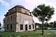
- Elassona Mosque
- Ottoman customs house of Elassona
- Panagia Olympiotissa Monastery
- Agia Triada Monastery, Sparmos
References
- "Απογραφή Πληθυσμού - Κατοικιών 2011. ΜΟΝΙΜΟΣ Πληθυσμός" (in Greek). Hellenic Statistical Authority.
- Koder, Johannes; Hild, Friedrich (1976). Tabula Imperii Byzantini, Band 1: Hellas und Thessalia (in German). Vienna: Verlag der Österreichischen Akademie der Wissenschaften. p. 153. ISBN 3-7001-0182-1.
- Kallikratis law Greece Ministry of Interior (in Greek)
- "Detailed census results 1991" (PDF). Archived from the original (PDF) on 2016-03-03. (39 MB) (in Greek and French)
- "Population & housing census 2001 (incl. area and average elevation)" (PDF) (in Greek). National Statistical Service of Greece. Archived from the original (PDF) on 2015-09-21.
External links
| Wikimedia Commons has media related to Elassona. |
- Elassona.gr - Elassona guide (in Greek)
- Elassona.com.gr - Elassona guide (in Greek)
Administrative division of the Thessaly Region | ||
|---|---|---|
| Regional unit of Karditsa | 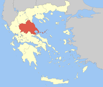 | |
| Regional unit of Larissa | ||
| Regional unit of Magnesia | ||
| Regional unit of the Sporades | ||
| Regional unit of Trikala | ||
| ||