El Dorado, Arkansas
El Dorado is a city in, and the county seat of, Union County, on the southern border of Arkansas, United States.[3] According to the 2010 census, the population of the city is 18,884.[4]
El Dorado, Arkansas | |
|---|---|
City | |
| City of El Dorado | |
 Jefferson Street in downtown El Dorado's Union Square District | |
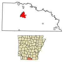 Location of El Dorado in Union County, Arkansas. | |
 El Dorado, Arkansas Location of El Dorado in Union County, Arkansas. | |
| Coordinates: 33°12′49″N 92°39′45″W | |
| Country | United States |
| State | Arkansas |
| County | Union |
| Founded | 1843 |
| Established | May 5, 1870 |
| Government | |
| • Type | Mayor–council |
| • Body | El Dorado City Council |
| • Mayor | Veronica Smith-Creer |
| Area | |
| • City | 16.20 sq mi (41.95 km2) |
| • Land | 16.19 sq mi (41.93 km2) |
| • Water | 0.01 sq mi (0.02 km2) |
| Highest elevation | 269 ft (82 m) |
| Lowest elevation | 249 ft (76 m) |
| Population (2010) | |
| • City | 18,884 |
| • Estimate (2019)[2] | 17,651 |
| • Density | 1,113.65/sq mi (429.99/km2) |
| • Metro | 44,170 Arkansas census statistical areas |
| Demonym(s) | El Doradoans |
| Time zone | UTC-6 (Central (CST)) |
| • Summer (DST) | UTC-5 (CDT) |
| ZIP codes | 71730, 71731, 71768 |
| Area code(s) | 870 |
| FIPS code | 05-21070 |
| GNIS feature ID | 0076861 |
| Highways | |
| Website | goeldorado |
El Dorado is headquarters of the Arkansas Oil and Gas Commission as well as Murphy Oil, Murphy USA, Deltic Timber Corporation and a DelekUS oil refinery. The city has a nationally-recognized downtown arts district, the Murphy Arts District (MAD); a community college, South Arkansas Community College (SouthArk); and a multi-cultural arts center, South Arkansas Arts Center (SAAC). El Dorado is the population, cultural and business center of south central Arkansas.
The city was the heart of the 1920s oil boom in the area. During World War II, it became a center of the chemical industry, which still plays a part in the economy, as do oil and timber. El Dorado is located approximately 120 miles (190 km) from the state capital of Little Rock.
History
On May 21, 1919, Frank Livingston, a black World War I veteran accused of murder with scant evidence, was burned alive by a mob in El Dorado.[5][6]
Geography
El Dorado is located at 33°12′49″N 92°39′45″W (33.213521, -92.662553).[7] in Union County, Arkansas in the southern part of the state. Union County is the largest county in the state of Arkansas and borders the state of Louisiana. The area has the unique feature of sharing its border with eight counties and parishes: Ouachita; Calhoun; Bradley; Columbia; Ashley; Claiborne Parish; Union Parish; and Morehouse Parish, Louisiana. El Dorado is the largest urban population center in its region.
According to the United States Census Bureau, the city has a total area of 16.3 square miles (42 km2), of which 16.3 square miles (42 km2) is land and 0.1 square miles (0.26 km2) (0.31%) is water.
Topography
El Dorado is located in the West Gulf Coastal Plain: In Arkansas, the West Gulf Coastal Plain covers the southeastern and south central portions of the state along the border of Louisiana. This Lowland area of Arkansas is characterized by pine forests and farmlands. Natural resources include natural gas, petroleum deposits and beds of bromine flats. The lowest point in the state is found on the Ouachita River in the West Gulf Coastal Plain of Arkansas.[8] El Dorado is located about 28 miles (45 km) to the west of Felsenthal National Wildlife Refuge, the world's largest green tree reservoir.
Climate
El Dorado is located in the humid subtropical zone (Köppen climate classification: Cfa).[9] El Dorado is hot during summer when high temperatures tend to be in the 90s (°F) and cool during winter when high temperatures tend to be in the 50s (°F).
The warmest month of the year is July with an average maximum temperature of 92.70 degrees Fahrenheit, while the coldest month of the year is January with an average minimum temperature of 32.90 degrees Fahrenheit.
Temperature variations between night and day tend to be moderate during summer with a difference that can reach 22 degrees Fahrenheit, and moderate during winter with an average difference of 23 degrees Fahrenheit.
The annual average precipitation at El Dorado is 54.11 inches. Rainfall is fairly evenly distributed throughout the year. The wettest month of the year is May with an average rainfall of 5.49 inches.
| Climate data for El Dorado | |||||||||||||
|---|---|---|---|---|---|---|---|---|---|---|---|---|---|
| Month | Jan | Feb | Mar | Apr | May | Jun | Jul | Aug | Sep | Oct | Nov | Dec | Year |
| Average high °F (°C) | 50 (10) |
56 (13) |
64 (18) |
73 (23) |
81 (27) |
89 (32) |
93 (34) |
92 (33) |
85 (29) |
75 (24) |
62 (17) |
53 (12) |
73 (23) |
| Average low °F (°C) | 31 (−1) |
35 (2) |
43 (6) |
50 (10) |
59 (15) |
68 (20) |
72 (22) |
71 (22) |
64 (18) |
51 (11) |
42 (6) |
34 (1) |
52 (11) |
| Average precipitation inches (mm) | 4.92 (125) |
4.0 (100) |
4.8 (120) |
5.3 (130) |
5.49 (139) |
3.9 (99) |
3.9 (99) |
3.8 (97) |
3.9 (99) |
3.8 (97) |
4.9 (120) |
4.7 (120) |
54.11 (1,374) |
| Source: [10] | |||||||||||||
Infrastructure
Major highways
.svg.png)


Airports

El Dorado has two airports, one commercial and a small general aviation airport, both of which are owned by the city. The South Arkansas Regional Airport at Goodwin Field offers mostly private aircraft, as well as commercial service via one airline carrier.[11] El Dorado's second airport is located within the city limits and closer to the downtown area. The El Dorado Downtown Airport has flights in and out for local industries, including Fortune 500 oil and gas companies and those who own small private planes have the option to lease or own their own hangar.
The airport was previously serviced by SeaPort Airlines, but flights ceased following SeaPort's liquidation on 20 September 2016. The US Department of Transportation announced 9 December 2016 that a new EAS contract had been awarded to Southern Airways Express to fly 18 weekly round trip non stop flights to Dallas Fort Worth.[12]
Utilities
El Dorado water is served locally by El Dorado Water Utilities, a private company categorized under Water and Sewage Companies-Utility. Current estimates show this company has an annual revenue of $10 to 20 million and employs a staff of approximately 50 to 99.[13] The electric power is provided by Entergy of Arkansas. Other utility companies serving El Dorado and surrounding areas include Centerpoint Energy (natural gas), Southern Lp-Gas Inc (Liquid Gas), Bcs Inc (Commercial and Residential Bottled Gas, Metered Gas Service), Suddenlink Television (Cable TV, Internet and Phone), Verizon Wireless, AT&T (residential and wireless phone services), among others.
Health systems
The city and surrounding area is served by the Medical Center of South Arkansas, MCSA, accredited by the Joint Commission on the Accreditation of Healthcare Organizations, is a general acute-care hospital licensed by the Arkansas Department of Health.[14]
Demographics
| Historical population | |||
|---|---|---|---|
| Census | Pop. | %± | |
| 1880 | 443 | — | |
| 1890 | 455 | 2.7% | |
| 1900 | 1,069 | 134.9% | |
| 1910 | 4,202 | 293.1% | |
| 1920 | 3,887 | −7.5% | |
| 1930 | 16,421 | 322.5% | |
| 1940 | 15,858 | −3.4% | |
| 1950 | 23,076 | 45.5% | |
| 1960 | 25,292 | 9.6% | |
| 1970 | 25,283 | 0.0% | |
| 1980 | 25,270 | −0.1% | |
| 1990 | 23,146 | −8.4% | |
| 2000 | 21,530 | −7.0% | |
| 2010 | 18,884 | −12.3% | |
| Est. 2019 | 17,651 | [2] | −6.5% |
| U.S. Decennial Census[15] | |||
As of the census[16] of 2010, there were 18,884 people, 8,969 households, and 5,732 families residing in the city. The population density was 1,323.3 people per square mile (510.9/km2). There were 9,969 housing units at an average density of 607.9 per square mile (234.7/km2). The racial makeup of the city was 49.9% Black or African American, 45.1% White, 0.30% Native American, 0.71% Asian, 0.8% Pacific Islander, 0.39% from other races, and 0.86% from two or more races. 1.04% of the population were Hispanic or Latino of any race.[17]
There were 8,686 households, out of which 30.7% had children under the age of 18 living with them, 42.9% were married couples living together, 19.1% had a female householder with no husband present, and 34.0% were non-families. Of 8,686 households, 304 are unmarried partner households: 243 heterosexual, 19 same-sex male, and 42 same-sex female. 30.7% of all households were made up of individuals, and 13.6% had someone living alone who was 65 years of age or older. The average household size was 2.40 and the average family size was 2.99.
In the city, the population was spread out, with 26.3% under the age of 18, 8.4% from 18 to 24, 25.9% from 25 to 44, 21.1% from 45 to 64, and 18.3% who were 65 years of age or older. The median age was 38 years. For every 100 females, there were 85.7 males. For every 100 females age 18 and over, there were 78.8 males.
The median income for a household in the city was $27,045, and the median income for a family was $34,753. Males had a median income of $30,876 versus $19,211 for females. The per capita income for the city was $16,332. About 20.0% of families and 24.6% of the population were below the poverty line, including 36.3% of those under age 18 and 13.8% of those age 65 or over.
Schools and education
According to the 2000 Census, 22.5% of the population age 25+ had an associate degree or higher.[18] More than 400 teachers and administrators work to meet the needs of all students regardless of age, ability, or background. Approximately 50 percent of these teachers and administrators hold advanced degrees.[19]
Public
More than 4,600 students attend the nine El Dorado public schools in the El Dorado School District #15.
Elementary
There are five elementary schools in the district divided into academies (K-4) and 1 (K-6):
- Hugh Goodwin Elementary School of the Arts
- Murmil Heights learning center
- Northwest Elementary School of Environment
- Retta Brown Elementary School of Communication and Technologies
- Yocum Elementary School of Math and Science
Secondary
- Washington Middle School (5-6)
- Barton Junior High School (7-8)
- El Dorado High School (9-12)
Post Secondary
- Professional Cosmetology Education Center is a private institution providing educational programs, services, and resources for students.[20]
El Dorado Promise
Provides graduates of the school with a scholarship covering tuition and mandatory fees that can be used at any accredited two- or four-year public or private educational institution in the US. The maximum amount payable is up to the highest annual resident tuition at an Arkansas public university.[21]
New El Dorado High School
A new high school was completed in June 2011. The new school is for 1,500 students and is a 320,000-sq-ft, 2-story structure made of wood, masonry, concrete, and steel. Located in the original 1920s oil field, the campus includes a 2,000 seat arena/gymnasium, 450-seat fine arts auditorium, and seven classroom zones on a site totaling 62 acres.[22]
The new EHS has more than 100 classrooms and instructional spaces, six dedicated computer labs, media center, theater with sloped and tiered lecture seating, a basketball arena, 75-seat “black box” theatre, 13 science labs, “Main Street” circulation corridors and central octunda, and an 8,000 sq ft (740 m2) student dining/commons with serving area.
Collegiate
South Arkansas Community College (SouthArk), is a public two-year institution providing educational programs, services, and resources for students. SouthArk offers degrees and certificates in health sciences, industrial technologies, liberal arts, and business.[23]
Private
- Maranatha Baptist Christian School (PK-12)
- West Side Christians School (PK-12) ANSAA Accredited School Website
- Light Brigade Christian Academy (PK-12)
A Roman Catholic school, Holy Redeemer School, operated in El Dorado until its 2005 closure.[24]
Parks and recreation
The city offers many outdoor activities and parks for recreation including tennis courts, baseball and softball fields, golf courses, and walking trails. The city also contains a botanical state park.
Parks
- Lions Club Park and Golf Course
- Mattocks Park
- Mosby Park
- Neel Park
- Old City Park
- South Side Park
Recreation Complex
El Dorado Recreation Complex and Pavilion has a playground area, multiple baseball/softball facilities and two spacious pavilions. It is home of the El Dorado High School Wildcat Baseball Field and Ladycat Softball Field.
South Arkansas Arboretum and Botanical Garden
The South Arkansas Arboretum is an arboretum and botanical garden owned by the local school system but operated as Arkansas's 50th state park by the South Arkansas Community College. It is adjacent to the old El Dorado High School. Opened in 1965, the arboretum is Arkansas's only state park located within a city. It includes more than two miles (3 km) of paved trails.[25]
Private sports clubs
El Dorado Golf and Country Club
The 18-hole course opened in 1925 features 6,449 yards of golf from the longest tees for a par of 71.[26]
El Dorado Racquet Club
Private Club - Accepts Non-Members. 4 stadium-lit outdoor hard surface tennis courts, pro shop, clubhouse, lounge, gym, swimming pools and banquet opportunities.[27]
Memorial Stadium
Memorial Stadium is a fully equipped 6,000-seat football stadium and track, and home of the El Dorado Wildcats. After a major field and stadium renovation in 2010, the stadium features a synthetic turf field and a video scoreboard. The stadium hosts sports events year round, most notably the Boomtown Classic, an annual college football match between in-state college football rivals.
Cultural
Performing arts
Murphy Arts District (MAD)
In fall of 2017, following years of planning and fundraising, the organization El Dorado Festivals and Events opened the Murphy Arts District, or MAD, in downtown El Dorado. The venture is a public-private partnership, supported by both private funds as well as local and state tax dollars. The first phase included a 2,500-capacity music hall, an 8,500-capacity outdoor amphitheater, a farm-to-table restaurant with a performance stage and the largest playscape in the state, which includes a small water park. The district features regular performances by nationally- and regionally-known musical acts, a farmer's market and many festivals and events.
South Arkansas Arts Center
El Dorado has been a regional center for the performing arts for many years. The South Arkansas Arts Center, or known locally as SAAC, is an independent community-supported nonprofit organization. The mission of the South Arkansas Arts Center in serving the people of the bi-state region is to promote, bridge, facilitate and support the ideas and forms of artistic appreciation, education, ability, confidence and cooperation for all age, cultural, social and racial groups. This 22,500-square-foot (2,090 m2) facility houses three visual art galleries, a ballet studio, a 207-seat theatre, educational classroom space, and an open studio for artists in the community.[28]
SAAC presents a series of eight to twelve contemporary performance events each year on stage and hosts rotating art exhibitions each year of national, regional and local significance in the Merkle, Price, and Lobby art galleries. SAAC also rents its performance facilities to independent groups who present their own programs in the Callaway Theatre, a 207-seat auditorium with a 35-foot (11 m) proscenium-style stage.[29]
Rialto Theater Music Hall


Built on the site of an earlier Rialto Theater (1921–1928), the Rialto Theater opened in 1929, with seating for 1,400, originally presenting both live stage shows in addition to films.[30] The Rialto Theater closed in 1980, but was restored in 1987 and reopened once more showing movies, subdivided into 3-screens. The theater closed again in the early 2000s to be renovated into a music hall with performances given weekly by local and touring musical acts and shows.
The Rialto was added to the National Register of Historic Places in 1986. It has long been rumored to be haunted. Dozens of former employees have reported unexplained footsteps, strange apparitions and even the fleeting scent of a woman’s cologne in an upstairs bathroom. Many supernatural experts and network television teams have spent time at the Rialto.[31]
Municipal Auditorium
The historic 1,830 seat El Dorado Municipal Auditorium is a multi-purpose auditorium facility with large lobby, grand hall seating, and multi-tiered sloping balcony. For more than 50 years, Municipal Auditorium has been the mainstay of many musical acts, entertainment shows, school productions, dance recitals and was formerly home to the South Arkansas Symphony Orchestra.
South Arkansas Symphony Orchestra
Founded in 1956 as one of the first orchestras in Arkansas, a group of local music lovers formed the El Dorado Symphony and Choral Society. The purpose of the organization was to form a symphony orchestra which would provide an outlet for musicians in the community, especially students of unusual ability. Felix Spooner, string instructor in the local schools, was named the conductor. The first concert was performed in 1957 by a 30 piece orchestra.
Annual events
El Dorado is the site for several annual events.
Beginning on the first Saturday in May, the Mayhaw Festival is hosted by the South Arkansas Historical Preservation Society.[32] The official event name is Bugs Bands & Bikes.[33] It coincides with a crawfish boil, a "Battle of the Bands", a bike show/one day motorcycle rally, a motorcycle parade, pool tournament, and other activities.
In September, the South Arkansas Community College Foundation hosts the SouthArk Outdoor Expo,[34] with outdoor activities and events targeted to anglers, hunters, children, and families.
During the first weekend of October, El Dorado celebrates the two-day MusicFest, a Music Festival which takes up eight city blocks, features over 30 acts on five stages and was named Arkansas Festival & Event Association 'Festival Of The Year' in 2007, 2009, 2011, 2012, 2013 and 2014.[35] Past headliners have included Toby Keith, the Charlie Daniels Band, Joan Jett and the Blackhearts, Tracy Lawrence, Kenny Wayne Shepherd, John Anderson, Eddie Money, Blues Traveler, Jack Ingram, Joe Nichols, Patrice Pike and Trout Fishing in America.[36]
El Dorado also hosts winter holiday events, including the Festival of Lights and the "largest Christmas parade in Arkansas".
Points of interest
El Dorado Conference Center
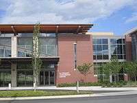
Built in 2010 and dedicated in 2011, this $14.4 million, 50,764-square-foot (4,716.1 m2) multi-purpose facility contains a large assembly hall with a capacity for 1,000 banquet style seating and theatre seating for up to 2,500. In addition to the main hall, there are 5 small meeting rooms that are capable of being joined together or separated by moveable walls to allow for many classroom, meeting or training arrangements. A full commercial kitchen facilitates catering and banquet dining. The building houses student services for South Arkansas Community College. This area includes a bookstore, café, meeting rooms, counseling, curriculum and financial advisement, training and testing rooms.[37]
Union County Courthouse
The Union County Courthouse was built from 1927 – 28 as a Greek revival by Mann & Stern architects of Little Rock. The original Union County Courthouse, built in 1844. As the county seat, El Dorado quickly outgrew even its second courthouse (built on this site in 1848) in the 1920s due to the oil boom's voluminous deed and title.[38][39]
Other points of interest
- Courthouse Square (including public artwork)
- Professional Cosmetology Education Center
- Historic Main Street Pizza
- Madison Square Shopping Center
- Murphy Oil Corp. headquarters located in downtown El Dorado
- Former West and Company department store outlet owned by H. O. West of Minden, Louisiana.
- Club Anthony
- The Blue Building
Media
Radio
El Dorado is home to several commercial radio stations owned by Noalmark Broadcasting Corporation.
- KMLK, 98.7 FM. The format is Urban adult contemporary.
- KDMS 1290 AM is a Southern Gospel station.
- KIXB KIX 103, () The Country Leader. The format is Country.
- KMRX Mix 96.1 FM, () The Continuous Hit Music Station. The format is Contemporary hit radio.
- KAGL 93.1 FM "The Eagle", () carries a Classic rock format.
- KELD AM 1400, "The Fan" () The format is 24hr Sports Talk.
- KELD-FM 106.5 FM (, licensed to Hampton, Arkansas in Calhoun County. The format is News Talk.
- KLBQ 101.5 FM () 101.5 The Hog. The format is classic country.
The public radio station is:
- KBSA 90.9 FM Red River Radio() is a four station public radio network and NPR affiliate based out of Shreveport, LA. As part of the network, KBSA became the first HD Digital Radio broadcaster in the South Arkansas region. The station and network is supported primarily through listener and corporate contributions.
El Dorado is also the home of KAKV, 88.9 FM, an owned and operated affiliate of the K-LOVE radio network.
Television
El Dorado broadcast outlets consist of three full-power television stations; two commercial, and one public.
- KTVE 10 (NBC)
- KEJB 43 (MNTV) (inc. 2001)
- KETZ 12 (PBS) local station of the Arkansas Educational Television Network (AETN) (inc. 2006)
All three transmitters are located east of El Dorado, in Huttig, Arkansas. While KTVE no longer considers El Dorado their primary newsroom, the station is licensed to El Dorado by the FCC. The station moved primary operations to Monroe, Louisiana in 1988.
Over the air HD television programming is currently available for two of the four major networks:
K20OC is a translator station of KNOE, the CBS affiliate in Monroe, Louisiana. However, the translator broadcasts KNOE's full HD signal; a major service to the HD viewers in Union County who cannot receive KNOE's main digital signal broadcasting from Columbia, Louisiana; over 75 miles (121 km) away.
Additionally, over the air television programming is also available from KETZ-DT, the AETN/PBS affiliate for El Dorado. Currently, KETZ broadcasts HD programming on channel 12.1, in 720p resolution.
El Dorado is also served by stations broadcast from nearby Shreveport and Monroe, Louisiana:
- KTBS 3 (ABC) - Shreveport
Monroe:
Print
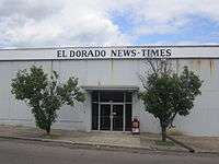
El Dorado is also served by the El Dorado News-Times, one of the oldest newspapers in South Arkansas. El Dorado News Times is a daily newspaper covering local news, sports, business, jobs, and community events.
El Dorado News-Times is owned by the Walter E. Hussman Company (WEHCO), owner of the state's largest newspaper, the Arkansas Democrat-Gazette.[40]
- Circulation: 9,371 copies
- Published seven days a week
- This newspaper is owned by Wehco Media Inc.
Notable people
- Daniel Gafford, NBA power forward for the Chicago Bulls
- Glenn D. Daniels, 1936-1992, founder of Country Music Television
- Donna Axum, 1964 Miss America
- Lou Brock, member of Baseball Hall of Fame
- Albert H. Crews, astronaut and United States Air Force officer
- Charlie Daniels, politician
- Candice Earley, actress
- Michael G. Fitzgerald, film historian and author
- David Frizzell, country music singer
- Lefty Frizzell, country music singer, born in Corsicana, Texas, reared in El Dorado
- Hogan Gidley, White House Deputy Press Secretary, former Executive Director of the South Carolina Republican Party; previously served as Press Secretary to the David Beasley for Senate campaign and Karen Floyd for Superintendent of Education; served on campaign committee of former U.S. Senator Elizabeth Dole of North Carolina
- Glen Ray Hines, professional football player
- Lamar Hunt, businessman, owner of Kansas City Chiefs, member of Pro Football Hall of Fame
- E. Fay Jones, architect and student of Frank Lloyd Wright
- Shara Nova, lead singer of My Brightest Diamond
- Qui Nguyen, playwright and founder of New York-based Vampire Cowboys Theatre Company
- Kevin Payne, NFL strong safety for the Carolina Panthers
- Charles Portis, author of True Grit
- William Ragsdale, actor
- Albert Rust, U.S. Representative
- Adam Setliff, two-time Olympic discus thrower
- Ron Simmons, investment advisor and member of Texas House of Representatives from Carrolltonfrom 2013 to 2019; lived partly in El Dorado prior to 1985[41]
- Reece Tatum, basketball player for Harlem Globetrotters
- Dave Whitlock, light heavyweight professional prizefighter who fought Floyd Patterson in September 1955
- Leon "Pee Wee" Whittaker, African American trombonist lived in El Dorado in early 1950s
- Travis Williams, NFL running back
- Josh Wilson, contemporary Christian musician
- Viper, rapper and record producer
International relations
Twin towns/Sister cities

References
- "2017 U.S. Gazetteer Files". United States Census Bureau. Retrieved Aug 22, 2018.
- "Population and Housing Unit Estimates". Retrieved May 21, 2020.
- "Find a County". National Association of Counties. Archived from the original on 2012-07-12. Retrieved 2011-06-07.
- "Population of the City of El Dorado, Arkansas". censusviewer.com. Retrieved August 9, 2012.
- McWhirter, Cameron (2011). Red Summer The Summer of 1919 and the Awakening of Black America. Henry Holt and Company. p. 52. ISBN 9780805089066.
- "Frank Livingston (Lynching of)". Retrieved 11 November 2018.
- "US Gazetteer files: 2010, 2000, and 1990". United States Census Bureau. 2011-02-12. Retrieved 2011-04-23.
- "Arkansas Geography from". Netstate. Retrieved 2012-08-19.
- "World Map of the Köppen-Geiger climate classification updated". University of Veterinary Medicine Vienna. 2008-11-06. Archived from the original on 2010-09-06. Retrieved 2010-09-25.
- "Weatherbase". Weatherbase. Retrieved 2012-08-19.
- "Resources > Airport > S Arkansas Regional Airport (El Dorado, AR) [KELD/ELD]". FlightAware. Retrieved 2012-08-19.
- "Regulations.gov". www.regulations.gov. Retrieved 2016-12-12.
- "El Dorado Water Utilities (City Of El Dorado) - El Dorado, Arkansas (AR) | Company Profile". Manta.com. Retrieved 2012-08-19.
- "Home - About Us". Themedcenter.net. Archived from the original on 2012-03-21. Retrieved 2012-08-19.
- "Census of Population and Housing". Census.gov. Retrieved June 4, 2015.
- "U.S. Census website". United States Census Bureau. Retrieved 2008-01-31.
- "El Dorado, AR ZIP codes, demographics, job listings, schools, income stats & more". Muninetguide.com. Retrieved 2012-08-19.
- "US Census Bureau Quick facts Sheet accessed 1 February 2007" (PDF). Archived from the original (PDF) on 7 April 2012. Retrieved 2012-08-19.
- El Dorado School District Home Page
- "Professional Cosmetology Education Center". Professional Cosmetology Education Center. Archived from the original on 2013-06-14. Retrieved 2013-01-27.
- "El Dorado Promise". El Dorado Promise. Retrieved 2012-08-19.
- "El Dorado High School, El Dorado, Ark. | South Central Construction | McGraw-Hill Construction". South Central Construction. 2010-06-01. Retrieved 2012-08-19.
- "SouthArk". Southark.edu. 1992-06-30. Retrieved 2012-08-19.
- Hargett, Malea (2013-03-28). "Despite 'year of grace,' St. Joseph School will close". Arkansas Catholic. Retrieved 2017-07-31.
- "South Arkansas Arboretum is adjacent to El Dorado HS on west gulf coastal plain". Arkansas State Parks. Retrieved 2012-08-19.
- McLean, Jim. "El Dorado Golf & Country Club | El Dorado Golf Course". Golflink.com. Retrieved 2012-08-19.
- "Tennis Club in El Dorado, AR 71730 // directions to El Dorado Racquet Club". Tennispoint.com. Retrieved 2012-08-19.
- "South Arkansas Arts Center and Theatre - El Dorado, AR - Events, Entertainment". Discoverourtown.com. Retrieved 2012-08-19.
- "South Arkansas Arts Center | El Dorado, AR". Saac-arts.org. 2010-07-29. Archived from the original on 2010-07-29. Retrieved 2012-08-19.
- "Rialto Theater". Cinema Treasures. Retrieved 2012-08-19.
- "Rialto Theater is indeed haunted". Spirit Seekers. Retrieved 2012-08-19.
- "Mayhaw Festival - South Arkansas Historical Preservation Society & the Newton House Museum". soarkhistory.com.
- "Bugs Bands & Bikes - Main Street El Dorado". mainstreeteldorado.org.
- "SouthArk Expo - South Arkansas Outdoor Expo". southarkexpo.com.
- "MyArkLaMiss - MusicFest El Dorado Named Festival of The Year". myarklamiss.com.
- "Main Street El Dorado - MusicFest". musicfesteldorado.com.
- "El Dorado Conference Center". Southark.edu. 2011-07-19. Archived from the original on 2011-07-19. Retrieved 2012-08-19.
- "Union County, Arkansas: History and Information". E-referencedesk.com. Retrieved 2012-08-19.
- "Union County, Arkansas". Arkansasties.com. 1983-06-30. Archived from the original on 2012-03-21. Retrieved 2012-08-19.
- "El Dorado News Times - daily newspaper in El Dorado, Arkansas USA with local news and events". Mondotimes.com. Retrieved 2012-08-19.
- "State Rep. Ron Simmons District 65 (R-Carrollton)". The Texas Tribune. Retrieved March 15, 2014.
- https://www.city.zentsuji.kagawa.jp/soshiki/1/rekishiyoukou.html
Further reading
External links
| Wikimedia Commons has media related to El Dorado, Arkansas. |
- Go El Dorado
- El Dorado Promise
- El Dorado News-Times
- South Arkansas Community College
- History of El Dorado's Jewish community (from the Institute of Southern Jewish Life)
- Encyclopedia of Arkansas History & Culture entry: El Dorado (Union County)
- The South Arkansas Leader
- KIX 103
- MIX96
- KAGL
- KELD
- KMLK
Municipalities and communities of Union County, Arkansas, United States | ||
|---|---|---|
| Cities | 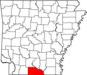 Map of Arkansas highlighting Union County | |
| Town | ||
| Unincorporated communities | ||
| Authority control |
|
|---|