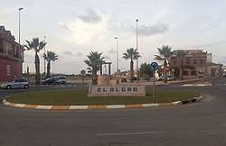
El Algar
El Algar is a district of the Spanish municipality Cartagena. It is located in the east of Cartagena and has an area of 26.659 km2. It shares borders with Lentiscar at its north, San Félix at its east, La Unión municipality at its south east, El Beal at its south-west and a coastal salty lagoon named Mar Menor at its north-west. In the year 2019, 7961 people were registered as inhabitants of the district.[2][3][4]
El Algar | |
|---|---|
Municipality district | |
 | |
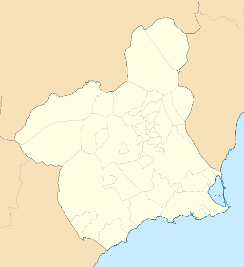 El Algar Location in Spain 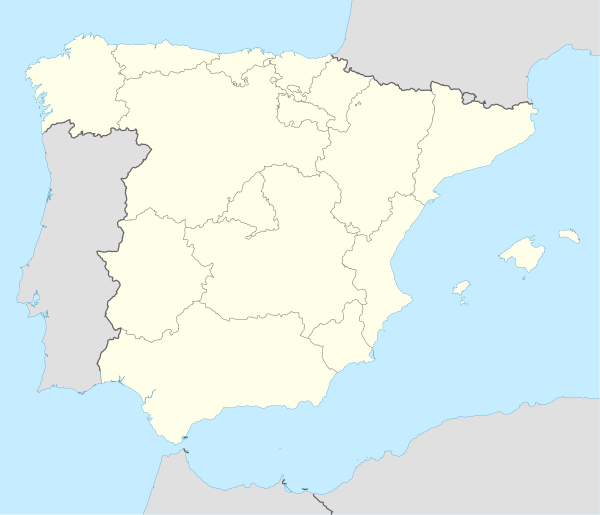 El Algar El Algar (Spain) | |
| Coordinates: 37°38′48.7316″N 0°52′0.2185″W | |
| Country | |
| Autonomous community | |
| Province | Province of Murcia |
| Comarca | Campo de Cartagena |
| Judicial district | Cartagena |
| Municipality | Cartagena |
| Government | |
| • Mayor | Ana Belén Castejón Hernández |
| Area | |
| • Total | 26.659 km2 (10.293 sq mi) |
| Population ()[1] | |
| • Total | 7,961 |
| • Density | 300/km2 (770/sq mi) |
| Demonym(s) | Algareños |
| Time zone | UTC+1 (CET) |
| • Summer (DST) | UTC+2 (CEST) |
| Postal code | 30366 |
| Dialing code | (+34) 968 |
Geography
Physical geography
The territory of the district is quite flat and there are only a raised landform: a hillock named Cabezo Álvarez. There are some flat spots like Fuente del Sapo and Saladar de Lo Poyo.[5] No beds with constant water flow traverses the district, but there are some arroyos (cheeks) or ramblas in El Algar.[6]
Human geography
In El Algar there are six localities. The main one has the name of El Algar and its population comes to 5567. The second most populated area is Las Lomas, where 1499 people live. There is also a village in the northeast of the territory which name is Los Urrutias and 848 peple reside there. A residential population centre also occupies El Algar and its name Estrella de Mar, which population consists of 275. There are also two hamlets: Los Rizos and Los Ruices. The first one is in the north of the district and 4 people live there. The second one is in the south and has a population of 10.[2][3]
History
There is evidence of presence of people during the Ancient Rome era. This consists in archaeological sites related to former villae, mining and metallurgic spots and farming sites.The territory was probably uninhabited during the late Roman Empire era.[7] During the Middle Ages, some path crossings occupied El Algar, according to some historians. Herds must have passed by the territory when being led to a mountain range named Sierra Minera. As a consequence, a settlement of shepherds was gradually set up. There are document references that date back to the years 1555 and 1565.[8]
During the Trienio Liberal, El Algar was not part of Cartagena municipality as usually, but of a municipality that existed just for that period of time. This also covered the current districts of Cartagena El Beal and Rincón de San Ginés.[9][10] When the period ended and an absolutist government system was again established, the new municipality ceased existing and El Algar belonged again to Cartagena.[9][10]
A mining boom took place in the current municipality of La Unión during the second half of 19th century and the first years of 20th. Owing to the proximity of El Algar to La Unión, some landowners received money profits resulting from shares of mining entreprises from the adjoining municipality. The economic fortunate fact brought these affluent people from El Algar on getting large and with a remarkable architectonical features.[10]
The first half of the 20th century there was a stagnation in El Algar as a consequence of the mining decay. Many inhabitants were prompted to migrate to Catalonia. In 1914, there was a trichinosis epidemic and it affected 275 people.[10]
Sports
Probably, the most remarkable element in regards to sports is the football team Club Deportivo El Algar (C.D. El Algar). Another sport team of the territory is a female one of volleyball named Surmenor.[11]
Every year, a popular race, which name is Subida a la Fuente del Sapo, occurs in one of the last days of August. An exceptional sport fact related to El Algar was Vuelta España 2018 (a Spanish national cycling competition) – part of sixth stage of the race occupied the main town of the district.[12][13]
Main sights
- Casa Rubio: It was a dwelling owned by a well-endowed man who was received economic profits from the mining activities of La Unión. The building was formed in 1895.[10][14]
- Apolo Theatre: It was built in 1905.[10][15]
- Zamar carriage museum: The museum includes carriages and ancient motorcycles.[16]
- Villa María[17]
- Some windmills: In Campo de Cartagena, there are windmills which are typical of the area and are of a same sort. Some of them are placed in El Algar.[18][19][20]
References
- Municipal Register of Spain 2018. National Statistics Institute.
- "Barrios y Diputaciones I Historia I Tu Ciudad I Ayuntamiento de Cartagena" (in Spanish). Retrieved 2020-02-13.
- "INEbase / Demography and population /Municipal Register. Population by municipality /Nomenclature: Continuous Register Population by Population Unit / Results". ine.es. Retrieved 2020-02-13.
- "Urbanismo Cartagena" (in Spanish). Retrieved 2020-02-13.
- "Mapa de Cabezo Álvarez en 30366, Murcia, España -Montana" (in Spanish). Retrieved 2020-02-13.
- "Urbanismo Cartagena" (in Spanish). Retrieved 2020-02-13.
- "El Algar- Historia de El Algar - Región de Murcia Digital" (in Spanish). Retrieved 2020-02-13.
- Gómez Vizcaíno, Juan Antonio. Pueblos de Cartagena. Diputaciones del Municipio Historia y Patrimonio (in Spanish). p. 40. ISBN 8493179086.
- Gómez Vizcaíno, Juan Antonio. Pueblos de Cartagena. Diputaciones del Municipio, Historia y Patrimonio. p. 41.
- "El Algar- Edad Contemporánea - Región de Murcia Digital" (in Spanish). Retrieved 2020-02-13.
- "I Torneo Algar Surmenor – Ayuntamiento de Cartagena".
- "Bodas de Plata de la Subida a la Fuente del Sapo - La Opinión de Murcia" (in Spanish). Retrieved 2020-02-13.
- "La Vuelta Ciclista a España recorrerá el jueves 43 kilómetros del municipio de Cartagena" (in Spanish). Retrieved 2020-02-13.
- "RPG_2012_2_Elem_F_160003" (PDF) (in Spanish). p. 160251. Retrieved 2020-02-13.
- "RPG_2012_2_Elem_F_160003" (PDF) (in Spanish). p. 160252. Retrieved 2020-02-13.
- "Museo de Carruajes Zamar - Región de Murcia Digital" (in Spanish). Retrieved 2020-02-13.
- "Modernismo en el Campo de Cartagena" (in Spanish). Retrieved 2020-02-13.
- "Molinos de Viento del Campo de Cartagena - Lista Roja del Patrimonio" (in Spanish). Retrieved 2020-02-14.
- "RPG_2012_1_Elem_F_160701" (PDF) (in Spanish). pp. 160715, 160723, 160724, 160725, 160727. Retrieved 2020-02-13.
- Mas Hernández, Ana. "Tecnologías tradicionales desparecidas: Los molinos del viento del Campo de Cartagena" (PDF) (in Spanish). Retrieved 2020-02-14.