Mar Menor
Mar Menor (Spanish pronunciation: [ˌmaɾ meˈnoɾ], "Minor sea" or "Smaller Sea". The Mediterranean Sea is also called "Larger Sea [Mar Mayor] in the region) is a coastal saltwater lagoon in the Iberian Peninsula located south-east of the Autonomous Community of Murcia, Spain, near Cartagena.
| Designations | |
|---|---|
| Designated | 4 October 1994 |
| Reference no. | 706[1] |
.jpg)
.jpg)
.jpg)
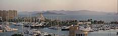
Four municipalities lie by the Mar Menor, Cartagena, Los Alcázares, San Javier and San Pedro del Pinatar. With a surface area of nearly 170 km2, a coastal length of 70 km, and warm and clear water no more than 7 metres in depth, it is the largest lagoon in Spain.
The lagoon is separated from the Mediterranean Sea by La Manga ("the sleeve", in Spanish), a sandbar 22 km in length whose width ranges from 100 to 1,200 metres, with Cape Palos in its south-eastern vertex making for the lagoon's roughly triangular shape. There are five islets located within the lagoon, namely Perdiguera islet, Mayor islet, Ciervo islet, Redonda islet and del Sujeto islet.
Its relatively high salinity, which aids flotation, and remarkable sporting infrastructures makes it a popular place for a wide variety of water sports.
Ecological importance
At the northern end there are salt-flats which include a wetland of international importance.[2] This area is preserved as a natural park administered by the regional government. Its Spanish name is "Salinas y Arenales de San Pedro del Pinatar". The microbes that live in this coastal lagoon have been recently described. [3]
The islets and the few coastal places without permanent human constructions are protected by the natural park Islets and open areas of the Mar Menor
In 1994 the Mar Menor was included on the Ramsar Convention list for the conservation and sustainable utilisation of wetlands. The Mar Menor is also part of a Specially Protected Area of Mediterranean Importance and is a Special Protection Area (ZEPA in Spanish) for bird life.
In July 2016 pollution was reportedly so severe as to render the area close to ecological collapse, following 18 years of neglected warnings. The public prosecutor's office is investigating allegations of negligence against the relevant authorities, which are governed by the conservative People's Party [4]
In May 2017 all beaches of the Mar Menor were stripped of their Blue Flag status as a result of the polluted condition of the Mar Menor in 2016.[5]
In October 2019 the pollution entering after floods in September led to thousands of dead fish lining the beaches, suffocating due to a lack of oxygen. [6]
Gallery
 Dawn at Mar Menor
.jpg) Boats, Mar Menor
Boats, Mar Menor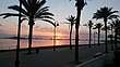 Dawn at Mar Menor
 Mar Menor seen from a golf course
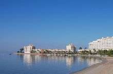 El Pedrucho, La Manga
 Dawn at Mar Menor
.jpg) Los Alcazares
Los Alcazares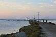 Mar Menor
 CASA C-101EB Aviojet of the Spanish Air Force at San Javier Airport
Panoramic view La Manga del Mar Menor

Notes
- "Mar Menor". Ramsar Sites Information Service. Retrieved 25 April 2018.
- Ghai R, Hernandez CM, Picazo A, et al. (2012). "Metagenomes of Mediterranean Coastal Lagoons". Scientific Reports. 2. doi:10.1038/srep00490. PMC 3391805. PMID 22778901.
- El Mar Menor, al borde del colapso
- Economia, Murcia. "El Mar Menor pierde 19 banderas azules". Retrieved 10 May 2017.
- Sánchez, Esther. "Why did thousands of dead fish wash up on Spain's Mar Menor?". Retrieved 24 October 2019.
External links
| Wikimedia Commons has media related to Mar Menor. |