Egloffstein
Egloffstein is a municipality in the district of Forchheim in Bavaria in Germany.
Egloffstein | |
|---|---|
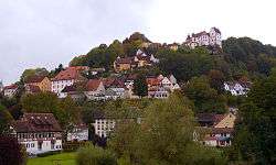 View from the west | |
 Coat of arms | |
Location of Egloffstein within Forchheim district 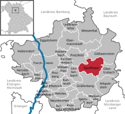 | |
 Egloffstein  Egloffstein | |
| Coordinates: 49°42′N 11°15′E | |
| Country | Germany |
| State | Bavaria |
| Admin. region | Oberfranken |
| District | Forchheim |
| Subdivisions | 8 Ortsteile |
| Government | |
| • Mayor | Christian Meier |
| Area | |
| • Total | 28.04 km2 (10.83 sq mi) |
| Highest elevation | 450 m (1,480 ft) |
| Lowest elevation | 350 m (1,150 ft) |
| Population (2018-12-31)[1] | |
| • Total | 2,066 |
| • Density | 74/km2 (190/sq mi) |
| Time zone | CET/CEST (UTC+1/+2) |
| Postal codes | 91349 |
| Dialling codes | 09197 |
| Vehicle registration | FO |
| Website | www.egloffstein.de |
Geography
Location
The village of Egloffstein is a state-recognised climatic spa and lies in the valley of the Trubach river on the hillside beneath the eponymous castle.
Neighbouring communities
Its neighbouring communities (clockwise from the north) are:
Gößweinstein, Obertrubach, Gräfenberg, Leutenbach, Pretzfeld
Administrative subdivisions
Egloffstein is divided into 16 parishes:[2]
|
|
- Affalterthal above Egloffstein in the upper part of the Mostvieler valley.
- Bieberbach is well known for its great Osterbrunnen. In 2005, however, it had to concede its title as the "Greatest Osterbrunnen in the World" to Sulzbach-Rosenberg. The village is first recorded in 1225.
- Hundshaupten is known for its wildlife enclosure and petting zoo, and for the castle of Hundshaupten.
Attractions
Above the village stands the former mediaeval castle of Egloffstein.
There is an open-air swimming pool that dates to before the war.
Towns and municipalities in Forchheim (district) | ||
|---|---|---|
| Coat of Arms of Forchheim district | |
References
- "Fortschreibung des Bevölkerungsstandes". Bayerisches Landesamt für Statistik und Datenverarbeitung (in German). July 2019.
- http://www.bayerische-landesbibliothek-online.de/orte/ortssuche_action.html?anzeige=voll&modus=automat&tempus=+20111102/171940&attr=OBJ&val=1195
| Authority control |
|
|---|
This article is issued from Wikipedia. The text is licensed under Creative Commons - Attribution - Sharealike. Additional terms may apply for the media files.