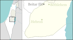
Efrat
Efrat (Hebrew: אֶפְרָת), or previously officially Efrata (Hebrew: אֶפְרָתָה), is an Israeli settlement established in 1983 and a local council in the Judean Mountains of the West Bank. Efrat is located 12 kilometers (7.5 mi) south of Jerusalem, between Bethlehem and Hebron, 6.5 km (4 mi) east of the Green Line, inside of the Security Barrier.[2] The settlement stands at an altitude of up to 960 metres (3,150 feet) above sea level and covers about 6,000 dunam (1,500 acres).[3] The international community considers Israeli settlements in the West Bank illegal under international law, but the Israeli government disputes this.[4][5]
Efrat
| |
|---|---|
| Hebrew transcription(s) | |
| • ISO 259 | ʔeprat, ʔepráta |
| • Also spelled | Efrata (previously) (official) |
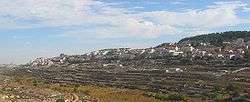 Efrat, 2012 | |
 Efrat | |
| Coordinates: 31°39′28.8″N 35°9′11.16″E | |
| Region | West Bank |
| District | Judea and Samaria Area |
| Founded | 1983 |
| Government | |
| • Type | Local council |
| • Head of Municipality | Oded Revivi |
| Area | |
| • Total | 6,280 dunams (6.28 km2 or 2.42 sq mi) |
| Population (2018)[1] | |
| • Total | 10,088 |
| • Density | 1,600/km2 (4,200/sq mi) |
Considered the capital of Gush Etzion,[6] it had a population of 10,088 in 2018. Although geographically located within Gush Etzion, it is independent from the Gush Etzion Regional Council, and Palestinians in negotiations do not consider it as part of that block, since it lies to the east of Route 60 — their side of the Geneva Initiative map.[6] Since November 2008, Oded Ravivi, an attorney and lieutenant colonel in the army and member of the Likud Central Committee is the head of Efrat regional council.[7]
Etymology
Efrat is named after the biblical place Ephrath. While according to the Israeli Ministry of the Interior, "Efrata" is the quotation from the Biblical verse, and therefore the town's name, Efrata's residents and municipality have maintained for many years that the reference isn't the location's name, but rather means "towards Efrat". This has recently changed, with the residents and municipality convincing the ministry of the interior of the correct name. The '-a' ending is common in Hebrew and may indicate female grammatical gender or mean 'her' or less frequent 'towards'. On the other hand, there are very clear biblical references to "Ephratah", in a context it cannot possibly mean "towards Ephrat", e.g. Ruth 4:11, 1 Chronicles 2:50, 1 Chronicles 4:4, Psalms 132:6, Micah 5:1. Therefore, there were until recently two names in use: Internal and private references speak of "Efrat", whereas all inter-city roadsigns, under purview of the National Government, read "Efrata" (and still do, not having been updated in light of the recent change).
Status under international law
Like all Israeli settlements in the Israeli-occupied territories, Efrat is considered illegal under international law, though Israel disputes this.[5] Most of the international community considers Israeli settlements to violate the Fourth Geneva Convention's prohibition on the transfer of an occupying power's civilian population into occupied territory.[8] Israel disputes that the Fourth Geneva Convention applies to the Palestinian territories as they had not been legally held by a sovereign prior to Israel taking control of them.[4] This view has been rejected by the International Court of Justice and the International Committee of the Red Cross.[9]
History
Bronze Age
The area in which Efrat was constructed was the site of a settlement during the Bronze Age. Archaeological excavations revealed a cemetery consisting of a tumulus built over a platform structure and more than twenty Bronze Age burial caves of the shaft tomb type, many of which had been reused over long stretches of time.[10]
Classical antiquity

One of the three ancient aqueducts supplying Jerusalem, the Wadi el-Biyar aqueduct (Hebrew: אָמָת הבִּיאָר), runs beneath Efrat.[10]
Modern Efrat
Modern Efrat was established in 1983 by Moshe Moskovits, who became the first mayor of Efrat and Shlomo Riskin, an Orthodox rabbi from New York City who settled in Efrat and became its Chief rabbi.[11] In January 2010, he made headlines, when he declared cigarettes as "treif" and together with Efrat's other chief rabbi Shimon Golan issued a prohibition against sale of cigarettes on halachic basis.[12]
Palestinian land claims
According to ARIJ, Israel confiscated land from four nearby Palestinian villages in order to construct Efrat:
Demographics
Efrat's population are mainly religious Zionist, with a small number of ultra-orthodox and of non-observant residents. There are more than twenty Orthodox synagogues, mainly Ashkenazi, but a Sephardi and a Yemenite synagogue also exist,[17] and there are several Yeshivot, and Kollelim. The population includes native-born Israelis, and immigrants who have made aliyah from the United States, United Kingdom, Australia, France, South Africa, Argentina, The Netherlands, Canada, and Russia.[18]
With a population of around 9,200 residents, Efrat is the largest settlement in the Gush Etzion settlement bloc, one of the settlement blocs that all Israeli governments have said they want to retain under any final-status agreement with the Palestinians.[19]
In early 2009, the Israeli Civil Administration declared some 1,700 dunams (170 hectares or 420 acres) of land called “Givat Eitam” (Eitam Hill) by the settlers and “Khallet An-Nahla” by the Palestinians, previously considered part of Bethlehem and the village of Artas to be "state land", after a military appeals committee approved an August 2004 decision which rejected objections against the confiscation of the land filed by Palestinian landowners. A farm is to be established on the land as a placeholder until a plan to build 2,500 homes on the site can be carried out, which would double the size of the settlement. The land in question is inside the official municipal boundaries of Efrat set in 1999,[20] but outside the separation barrier. Originally, “Givat Eitam” was included on the western side of the barrier, but as the result of deliberations in the High Court of Justice the route had to be changed and excludes “Givat Eitam”. According to Haaretz, “it can be expected that the establishment of the farm will be followed by the building of an access road and the deployment of IDF soldiers and other security arrangements, to guarantee the area's future role as part of Efrat”.[21]
In December 2011, it was reported that the IDF has also agreed to the expansion of Efrat and the Gush Etzion bloc with 40 single-family homes toward the north and north-east on “Givat Hadagan”, replacing the unauthorized trailer park of the campus of Yeshivat Siach Yitzhak on the site. “Givat Hadagan”, originally planned as a neighborhood of 500 homes in the 1990s, is located a few hundred meters from the Dheisheh refugee camp and from the Palestinian town of al-Khader, south of Bethlehem. Ten of the 40 planned houses are to be sold as finished houses comprising up to 160 square meters each, and the buyers of the remaining 30 lots will arrange for the construction of their homes themselves. After they are completed, the Jewish settlements in northern Gush Etzion will reach the edges of Bethlehem's southernmost suburbs. Earlier, the construction of 277 homes on a third hill in Efrat, called “Givat Hazayit”, had been approved as a reaction to the UNESCO's accepting Palestine as a full member.[21]
Neighborhoods
Efrat is made up of seven neighborhoods named for the Seven Species: Rimon (pomegranate), Te'ena (fig), Gefen (grapevine), Dekel (date palm), Zayit (olive), Tamar (date), and Dagan (grain - symbolizing both wheat and barley).[18]
References
- "Population in the Localities 2018" (XLS). Israel Central Bureau of Statistics. 25 August 2019. Retrieved 26 August 2019.
- "Efrata". Peace now. Archived from the original on 2011-09-27.
- "The city of Efrat". Efrat Municipality Website. Archived from the original on August 9, 2011. Retrieved August 24, 2011.
- "The Geneva Convention". BBC News. 10 December 2009. Retrieved 27 November 2010.
- "Israel announces plans for 1,400 new settlement homes". BBC. 10 January 2014.
The settlements are considered illegal under international law, though Israel disputes this...Israel's housing ministry issued tenders for the construction of 801 housing units in West Bank settlements, including Efrat, Elkana and Emanuel, and 600 in Ramat Shlomo in East Jerusalem.
- Jodi Rudoren, Jeremy Ashkenas,'Netanyahu and the Settlements,' The New York Times 12 March 2015.
- Chaim Levinson (June 17, 2010). "Interview with Efrat regional council head Oded Ravivi. What's your position on settler violence?". Haaretz. Retrieved August 24, 2011.
- Raffi Berg (19 December 2005). "Gaza evictees settle in West Bank". BBC News. Retrieved August 24, 2011.
- "Legal Consequences of the Construction of a Wall in the Occupied Palestinian Territory" (PDF). International Court of Justice. 9 July 2004. pp. 44–45. Archived from the original (PDF) on 6 July 2010. Retrieved August 24, 2011.
- Rivka Gonen, ed. (2001). Excavations at Efrata: A Burial Ground from the Intermediate and Middle Bronze Ages. Israel Antiquities Authority Reports 12. Israel Antiquities Authority. ISBN 965-406-076-0.
- "Rabbi Dr. Shlomo Riskin". Ohr Torah Stone. Archived from the original on September 6, 2011. Retrieved August 24, 2011.
- Gil Hoffman (January 27, 2010). "Smoking MK slams Riskin's effort to snuff out cigarettes". The Jerusalem Post. Retrieved August 24, 2011.
- Al Khader Town Profile, p. 20, ARIJ
- Wadi an Nis Village Profile, ARIJ, p. 16
- Artas Village Profile, ARIJ, p. 17
- Beit Sakariya Village Profile, ARIJ, p. 17
- Erica Danielle Chernofsky (July 13, 2006). "Guns 'n' roses". The Jerusalem Post. Retrieved August 24, 2011.
- "Nefesh B'Nefesh Community Guide for Efrat". Nefesh B'Nefesh. Retrieved August 24, 2011.
- Nadav Shragai (February 17, 2009). "West Bank settlement gets green light for major expansion". Haaretz. Retrieved August 24, 2011.
- Lara Friedman; Hagit Ofran (February 27, 2009). "Zero tolerance now". Haaretz. Retrieved August 24, 2011.
- Chaim Levinson (12 December 2011). "IDF agrees to expansion of West Bank settlement". Haaretz. Retrieved 2011-12-14.
External links
| Wikivoyage has a travel guide for Efrat. |
| Wikimedia Commons has media related to Efrat. |
- Efrat Municipality Website in English
- Nefesh B'Nefesh Community Guide for Efrat
- Sharon Udasin (May 25, 2011). "Efrat goes green, starting with its children". Jerusalem Post.
- Mayor Oded Revivi (September 7, 2014). "Its time to learn the facts about Judea and Samaria". Jerusalem Post.
| Cities | ||
|---|---|---|
| Regional committee | ||
| Regional councils | ||
| Local councils | ||
| See also | ||