East Ural Nature Reserve
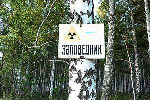
East Ural Nature Reserve (Russian: Восточно-Уральский заповедник) is a Russian 'zapovednik' (strict nature reserve) that is near the site of the 1957 Kyshtym disaster, currently ranked the world's third worst nuclear disaster. As a state "radiation reserve", the site functions for the protection of a contaminated area, and for long-term scientific study of the effects of radiation on the forest-steppe ecology on the east slope of the southern Ural Mountains. The reserve is situated in the Ozyorsk, Chelyabinsk Oblast. It was formally established in 1968, and covers 16,600 ha (64 sq mi). The reserve, as of 2007, is under the control of Rosatom, a state-run corporation, which conducts regular radiation and radio ecological monitoring.[1][2][3]
| East Ural Nature Reserve | |
|---|---|
| Russian: Восточно-Уральский заповедник | |
IUCN category Ia (strict nature reserve) | |
 East Ural Zapovednik | |
 Location of Reserve | |
| Location | Chelyabinsk Oblast |
| Nearest city | Chelyabinsk |
| Coordinates | 55°48′52″N 60°53′58″E |
| Area | 16,600 hectares (41,019 acres; 64 sq mi) |
| Established | 1968 |
| Governing body | Ministry of Natural Resources and Environment (Russia) |
Topography
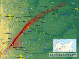
The East Ural Reserve is oblong in shape, pointing towards the northeast, with a width of approximately 10 km and a length of 50 km.
Ecoregion and climate
East Ural Nature Reserve is located in the West Siberian taiga ecoregion, a region that covers the West Siberian Plain, from the Urals to the Central Siberian Plateau. It is a region of extensive conifer boreal forests, and also extensive wetlands, including bogs and mires.[4]
The climate of East Ural Nature Reserve is humid continental climate, cool summer (Köppen climate classification subarctic climate). This climate is characterized by mild summers (only 1-3 months above 10 °C (50.0 °F)) and cold, snowy winters (coldest month below −3 °C (26.6 °F)).[5][6]
Ecoeducation and access
As a state radiation and strict nature reserve, the East Ural Reserve is not accessible to the public.
References
- Bakur, AS. "The radiation and radio-ecological monitoring in the zone of influence of the FSUE "PA" Mayak "". Mineco Regional Almanac. Nature Conservation of Southern Ural, '08. Archived from the original on 17 June 2016. Retrieved 5 June 2016.
- "East Ural Zapovednik". Zapovednik Mira. Zapovednik Mira. Retrieved 5 June 2016.
- Raspopov, Pavel. "East Ural Radiation Reserve". Uraloved. Uraloved. Retrieved 5 June 2016.
- "Map of Ecoregions 2017". Resolve, using WWF data. Retrieved September 14, 2019.
- Kottek, M., J. Grieser, C. Beck, B. Rudolf, and F. Rubel, 2006. "World Map of Koppen-Geiger Climate Classification Updated" (PDF). Gebrüder Borntraeger 2006. Retrieved September 14, 2019.CS1 maint: multiple names: authors list (link)
- "Dataset - Koppen climate classifications". World Bank. Retrieved September 14, 2019.