East Coast Trail
The East Coast Trail (ECT) is a long-distance coastal footpath located in the Canadian province of Newfoundland and Labrador. It is a developed trail over 300 kilometres (190 mi) long, creation of which began in 1994. It is made up of 26 linked wilderness paths and passes through more than 30 communities.[1] It was named one of the best adventure destinations by National Geographic in 2012 and is extended and improved yearly.[2]
| East Coast Trail | |
|---|---|
| Length | 540 km (336 mi) |
| Location | Newfoundland, Canada |
| Trailheads | Near St. John's; Cappahayden |
| Use | Hiking |
| Hiking details | |
| Trail difficulty | Easy to Strenuous |
| Season | Year Round |
Maintained by the East Coast Trail Association and located primarily on public lands, the trail follows the east coast of Newfoundland along the Atlantic Ocean. The path passes through many small coastal outports (villages) in the bays of the Avalon Peninsula. The trail runs from Topsail Beach, north to Cape St. Francis, then south through St. John's, and continues south as far as Cappahayden.[1] It is intended that the trail will eventually be extended to Trepassey in the south and across to Placentia in the west (from Ferryland).[3]
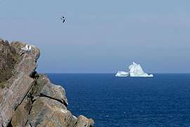
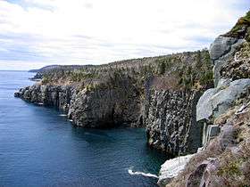
The trail also passes several National historic sites, including Signal Hill, St. John's, Cape Spear, the easternmost point in North America (ignoring Greenland), and Ferryland, the site of the 17th-century Colony of Avalon. It also passes through La Manche and Chance Cove Provincial Parks. There are seasonal views of icebergs, birds, whales, other marine and plant life, and eight historic lighthouses along the path. The individual sections of the trail range in hiking time from a few hours to a full day; there are some designated camping spots along the trail, though most walkers use local accommodation.[1]

History
The Trail officially began in 1994 "when a group of hiking enthusiasts started the construction of a coastal trail" that would make use of existing traditional trails that linked local communities along the coast of the Avalon Peninsula. The following year the East Coat Trail Association was incorporated and it was subsequently was registered aa charity. The initial plan "was to build and maintain" a long distance coastal footpath from Topsail Beach to Trepassey and in 1997 the Association obtained funds from the Federal Government to develop this 220 km trail. In 2001 this trail was officially opened.[4] Subsequently, the route has been extended from St. John's, with the last section between Topsail Beach and Portugal Cove, now walkable and due for final upgrading this summer.[5]
The final goal is "540 km of coastal and inland trail", which will include the completion of the trail between Capperhayden and Treppassey, and side trails from Ferryland, namely the 90 kilometres D'Iberville Trail, crossing the Avalon Wilderness Reserve from Ferryland to Placentia, connecting Lord Baltimore's Colony of Avalon to Castle Hill, Placentia and the 30 kilometres Masterless Men Path, an inland route stretching all the way to the Butterpot, linking Ferryland and Renews.[6][7]
The D'Iberville Trail is named after the French explorer and soldier Pierre Le Moyne d'Iberville. The Masterless Men trail takes its name from "a legendary outlaw society (fl late 18th, early 19th centuries ... [of] men escaping press gangs, Royal Navy deserters and runaway indentured servants from Newfoundland fishing plantations who fled inland to escape their harsh life. ... said to have inhabited the wild Butter Pot barrens of the Avalon Peninsula".[8]
Route
All timings are for a one-way hike.
Tosail Beach to St John's
The trail runs mainly along the southern coast of the Avalon Peninsula, but initially, as far as Cape St. Francis, the direction is northerly.
Long Shore Path (Topsail Beach - Portugal Cove) A 17.2-kilometre (10.7 mi) moderate to difficult path that takes 6 to 8 hours. This path has been opened and is scheduled for completion by August 2020. It passes through St. Thomas, St. Philips, and Beachy Cove. Regular ferry service to Bell Island from Portugal Cove.[9]
Piccos Ridge Path (Portugal Cove - Bauline) A 14.5-kilometre (9.0 mi) strenuous hike on high, open ground, of 7–8 hours. This path is considered undeveloped with minimal structures. The path has been cut and signed. There are long stretches of exposed trail so caution is advised. Exercise caution in all areas, especially on the steep north slope of Black Cliff.
White Horse Path 18.2 km (Bauline - Cape St. Francis) A 17.5-kilometre (10.9 mi) strenuous hike, 8–10 hours. This is still an undeveloped path with steep ascents and descents and wetland crossings, so caution is advised. Wilderness Patch Brook campsite.
Biscan Cove Path (Cape St. Francis - Pouch Cove) A 7.3-kilometre (4.5 mi) hike, of moderate difficulty, about 2–4 hours. The route can be challenging with steep hills.
Stiles Cove Path (Pouch Cove - Flatrock) A 15.1-kilometre (9.4 mi) hike of moderate difficulty. It takes 5–7 hours to complete. There are various access point. Swimming and picnic areas. [10]
Father Troy's Trail (Flatrock - Torbay) An 8.7-kilometre (5.4 mi) easy hike, 2–4 hours, that follows the old cart road between the two communities and is "one of the few old roads on the Avalon to have retained its pre-automotive character".[11] It features a stony beach, Tappers Cove wharf and mural and the Beamer, a rock formation. There is a less difficult inland alternatives at Church Cove.[12]
Silver Mine Head Path 3.8-kilometre (2.4 mi) (Torbay - Outer Cove)
A 2.4-kilometre (1.5 mi) easy hike, of 1–2 hours. Features Middle Cove beach park and views to Torbay point and Flatrock. [13]
Cobblers Path (Outer Cove to Logy Bay)
A 8.2-kilometre (5.1 mi) hike of moderate difficulty, that takes 3–4 hours. It is a popular, partially boarded hike that features "The Cobbler" (a five finger-like rock formation), the remains of a Pinetree Line radar station and seasonal whale watching.[14]
Sugarloaf Path (Logy Bay - Quidi Vidi Village) A 8.9-kilometre (5.5 mi) hike that is at times difficult and takes 3–5 hours. It has varied terrain and features Sugarloaf Head and rock formations. It also has a view of St. John's and Quidi Vidi. [15]
City of St. John's: Quidi Vidi to Fort Amherst
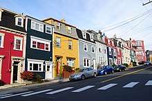
The official ECT map shows a route through St John's via Cuckold's Cove, Cabot Tower, Signal Hill and The North Head Trail to The Battery. In addition The Grand Concourse Trailway system offers a choice of possible routes to Downtown St John's.[16] From St John's to Fort Amherst, the ECT map again offers guidance. The route goes around the harbour, with a short-cut across a bridge across from the Railway Coastal Museum.[17] Amongst the attraction's found in St Joh's are boat trips to view icebergs, and whales; The Rooms; Quidi Vidi Lake; Memorial University's Botanical Garden; the Johnson Geo Centre, a geological interpretation centre located on Signal Hill; historic Downtown, including the Basilica, St John's and Anglican Cathedral, St John's. There is also the Grand Concourse's extensive network of hiking trails within the city, and around its lakes, along its rivers, and through other open spaces.
St John's to La Manche
The road connecting the settlements running south from St. John's – Route 10 – is known as the Irish Loop, because the communities were mainly sealed by Irish immigrants.[18]
Deadmans Bay Path (Fort Amherst - Blackhead)
A 10.6-kilometre (6.6 mi) moderate to difficult route that takes 5–8 hours. There are path features side trails that can increase distance and time. There are steep ascents and descents. The route passes the Fort Amherst lighthouse, the former settlement of Freshwater, and a barachois with remains of the Vasco d'Orey shipwreck. The Nature Conservancy of Canada has a reserve at Freshwater.[19] There are also seasonal swimming holes, berry grounds and bird nesting views.[20] There are side trails to this path from Shea Heights and the Cape Spear Road.[21]
Cape Spear Path (Blackhead - Maddox Cove)
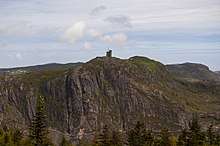
A 9.3-kilometre (5.8 mi) path of moderate difficulty that takes 4–6 hours. The trail includes side trails. The path varies in terrain and features a nature conservancy area, Cape Spear National Historic Site, a lighthouse, a museum, and whale watching.[22] The lighthouse Cape Spear is Newfoundland and Labrador’s oldest surviving lighthouse and "has been restored to its 1839 appearance and visitors are able to see what it would have been like for a lighthouse keeper and his family to live there in the mid-19th century".[23] (See also the Blackhead Path a 3.7-kilometre (2.3 mi) path between the small community of Blackhead and Cape Spear, that is easy to moderate in difficulty. It takes 1–2 hours to complete. The path is very exposed to the weather so caution is advised. Cabot Tower can be seen across the sea and the path ends at Cape Spear National Historic Site with its historic lighthouse).
Motion Path (Petty Harbour - Shoal Bay Road)
Walk through the two communities to the start in Petty Harbour. A 13.5-kilometre (8.4 mi) that is moderate to difficult. It takes 7–9 hours. There are steep ascents and descents on this "wild and exposed coastal trail".[24]. A 6.3-kilometre (3.9 mi) access path along Shoal Bay Road from the highway.
Spout Path (Shoal Bay Road - Bay Bulls) A 16.3-kilometre (10.1 mi) long and hilly path that is difficult to strenuous. It takes 5–8 hours. The path passes the Spout, historic lighthouses, waterfalls, sea cliffs and sea stacks.The trail can be accessed via Shoal Road (6.4-kilometre (4.0 mi)) from the highway. [25]
Mickeleens Path (Bay Bulls - Witless Bay)
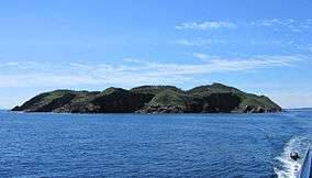
A 7.3-kilometre (4.5 mi) walk of easy to moderate difficulty that takes 2–4 hours. The terrain varies from woods, meadows and cliffs. The islands of the Witless Bay Ecological Reserve, can be seen, and there red sandstone cliffs, and views of coves, sea stacks, gulches. [26] In season there are boat trips from Witless Bay and Bay Bulls to view icebergs, whales, and the seabird colonies on the island's offshore.[27]
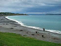
Beaches Path 7.1 km (Witless Bay - Mobile) An easy 7.0-kilometre (4.3 mi) hike, taking 2–3 hours. It is a shoreline walk with mild elevation changes and there are a picnic area, and Mobile Beach. Witless Bay Ecological Reserve lies offshore.[28]
Tinkers Point Path 5.0 km (Mobile - Tors Cove)
A 5.1-kilometre (3.2 mi) easy hike that takes 2–3 hours. There is beach access, picnicking, and seasonal bird and whale watching. [29]
La Manche Village Path (Tors Cove - La Manche Village)
A 6.4-kilometre (4.0 mi), easy hike that takes 2–3 hours. It is a relatively flat path though the woods that passes through La Manche Provincial Park, 50-metre (160 ft) across a suspension bridge and, offshore, the islands of the Witless Bay Ecological Reserve can be seen. The Reserve contains North America´s largest Atlantic puffin colony. and the world's second-largest colony of Leach's storm-petrels. 1.4-kilometre (0.87 mi) access trail from the highway.[30]
La Manche to Capperhayden

Flamber Head Path (La Manche Village - Brigus South)
A 11.5-kilometre (7.1 mi), moderate to difficult route that takes 6–9 hours. The wooded path passes through the resettled village of La Manche. The village was abandoned following the destruction caused "by a tidal wave in 1966". This destroyed the suspension bridge linking the community with Bauline East.[31] There is waterfalls and wilderness camping and seabird and seasonal whale watching.[32] A 1.4-kilometre (0.87 mi) access trail from the highway.
Brigus Head Path (Brigus South - Admirals Cove) This 6.5-kilometre (4.0 mi) route is of moderate difficulty and takes 2–4 hours. It features Hares Ears rock formation at Hares Ears Point.[33]
Cape Broyle Head Path 19.4 km (Cape Broyle – Calvert) A 18.3-kilometre (11.4 mi) long route that is difficult to strenuous and takes 6–8 hours. A hilly hike has stream crossings. It features a sandy beach, twisted rock formation, campsite and views of Ferryland's lighthouse.[34]
Caplin Bay Path 5.6 km (Calvert - Ferryland) A 5.2-kilometre (3.2 mi) easy hike of 2–3 hours. A wooded walk with meadows and a section of elevated, old railroad track, and beaches and ocean views. There are side trails to Ferryland harbour and lighthouse.
Sounding Hills Path (Ferryland - Aquaforte) CLOSED
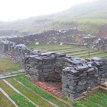
This is a 5.5-kilometre (3.4 mi) hike of easy to moderate difficulty. It takes 2–4 hours. The path goes through woods and along a stretch of Spout River. It passes close to the Colony of Avalon, National Historic archaeological site and interpretation centre, an old stone church, museum, tea room and dinner theatre.[35]
Mudder Wet Path (South West River – Aquaforte)
A 2.9-kilometre (1.8 mi) easy hike that takes 1–2 hours, It is a peaceful walk through the woods with views of tidal estuaries and waterfalls. [36]
Spurwink Island Path 20.4 km (Aquaforte - Port Kirwan)
This a 17.1-kilometre (10.6 mi) long challenging hike that takes 7–9 hours. There are views of Ferryland lighthouse, Berry Head sea arch and there is a wilderness campsite on the path.[37]
Bear Cove Path 11.9-kilometre (7.4 mi) Kingman's Cove and Renews)
A 11.6-kilometre (7.2 mi) hike of moderate difficulty. It takes about 4–6 hours. There are two historic sites, a settlement, lighthouse, and seasonal berry grounds. [38]
Island Meadow Path (Renews - Cappahayden) A 10.1-kilometre (6.3 mi) hike of moderate difficulty that takes 4–6 hours, that is primarily made up of woodlands and headlands, and there are views of Renews Island.[39]
Capperhayden to Trepassey
Not yet developed
Capperhayden to Trepassey via Chance Cove, Cape Race Lighthouse, Portugal Cove South and Mistaken Point Ecological Reserve.
Capperhayden to Chance Cove Provincial Park is undeveloped and includes gravel road, rough trail, moose path, bush-whacking, trackless bog, and deep river crossings.[40] Chance Cove Provincial Park is a provincial park located approximately 20.0-kilometre (12.4 mi) south of Renews-Cappahayden. Chance Cove was once the site of a small settlement of approximately 50 people in the mid-19th century, but it "was abandoned between 1884 and 1891 following a series of disastrous years in the fishery".[41].
Chance Cove to Cape Race is another difficult undeveloped, unmarked route, especially the middle section.[42]
Cape Race to Trepassey. There is a 32.75-kilometre (20.35 mi) road between Cape Race, Portugal Cove South, and Trepassey[43] that passes Mistaken Point Ecological Reserve a wilderness area and a UNESCO World Heritage Site. The reserve is home to the Mistaken Point Formation, which contains one of the most diverse and well-preserved collections of Precambrian fossils in the world. Ediacaran fossils discovered at the site constitute the oldest known remnants of multicellular life on Earth.[44]
Portugal Cove South is 19-kilometre (12 mi) from Cape Race.
Accommodation
There are primitive campsites on longer paths and campsites within Provincial Parks.
For B&B, etc. see:
Transportation
Buses can be used to access Logy Bay, including road walk; Quidi Vidi; Fort Amherst with road walk; Shea Heights for Deadman's Bay and Freshwater; Shoal Bay Road.[45] There is minibus taxi service to and from Treppassey;[46] Cape Spear (seasonal bus – frequent service).[47]
Natural Environment
Landscape
The Avalon Peninsula has over 2,500 kilometres of coastline, much of which rises abruptly from the sea and is indented with numerous bays and inlets. The landscape consists of forest, heathlands, bogs, fens, marshes, many large rivers and numerous ponds.[48]
Climate
| Climate data for Logy Bay-Middle Cove-Outer Cove | |||||||||||||
|---|---|---|---|---|---|---|---|---|---|---|---|---|---|
| Month | Jan | Feb | Mar | Apr | May | Jun | Jul | Aug | Sep | Oct | Nov | Dec | Year |
| Record high °C (°F) | 16.0 (60.8) |
16.0 (60.8) |
15.0 (59.0) |
24.0 (75.2) |
26.7 (80.1) |
30.0 (86.0) |
30.0 (86.0) |
31.0 (87.8) |
30.0 (86.0) |
24.0 (75.2) |
25.0 (77.0) |
15.0 (59.0) |
31.0 (87.8) |
| Average high °C (°F) | 0.3 (32.5) |
0.0 (32.0) |
2.1 (35.8) |
6.0 (42.8) |
11.0 (51.8) |
15.7 (60.3) |
20.4 (68.7) |
20.7 (69.3) |
16.9 (62.4) |
11.4 (52.5) |
7.0 (44.6) |
2.6 (36.7) |
9.5 (49.1) |
| Daily mean °C (°F) | −3.6 (25.5) |
−4.0 (24.8) |
−1.5 (29.3) |
2.4 (36.3) |
6.6 (43.9) |
10.8 (51.4) |
15.6 (60.1) |
16.3 (61.3) |
12.8 (55.0) |
7.9 (46.2) |
3.7 (38.7) |
−0.9 (30.4) |
5.5 (41.9) |
| Average low °C (°F) | −7.4 (18.7) |
−8.0 (17.6) |
−5.1 (22.8) |
−1.3 (29.7) |
2.2 (36.0) |
6.0 (42.8) |
10.7 (51.3) |
11.9 (53.4) |
8.6 (47.5) |
4.3 (39.7) |
0.3 (32.5) |
−4.3 (24.3) |
1.5 (34.7) |
| Record low °C (°F) | −24.4 (−11.9) |
−25.0 (−13.0) |
−23.3 (−9.9) |
−14.0 (6.8) |
−7.0 (19.4) |
−3.3 (26.1) |
−1.1 (30.0) |
3.5 (38.3) |
−1.1 (30.0) |
−8.0 (17.6) |
−13.0 (8.6) |
−25.0 (−13.0) |
−25.0 (−13.0) |
| Average precipitation mm (inches) | 122.5 (4.82) |
113.6 (4.47) |
102.9 (4.05) |
99.8 (3.93) |
83.2 (3.28) |
94.7 (3.73) |
86.8 (3.42) |
94.4 (3.72) |
121.1 (4.77) |
134.6 (5.30) |
126.0 (4.96) |
128.7 (5.07) |
1,308.1 (51.50) |
| Average rainfall mm (inches) | 72.9 (2.87) |
68.6 (2.70) |
77.6 (3.06) |
89.9 (3.54) |
81.4 (3.20) |
94.7 (3.73) |
86.8 (3.42) |
94.4 (3.72) |
121.1 (4.77) |
134.1 (5.28) |
116.7 (4.59) |
96.5 (3.80) |
1,134.6 (44.67) |
| Average snowfall cm (inches) | 49.6 (19.5) |
45.0 (17.7) |
25.3 (10.0) |
9.9 (3.9) |
1.8 (0.7) |
0.0 (0.0) |
0.0 (0.0) |
0.0 (0.0) |
0.0 (0.0) |
0.4 (0.2) |
9.3 (3.7) |
32.2 (12.7) |
173.6 (68.3) |
| Source: Environment Canada[49] | |||||||||||||
Wildlife
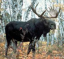
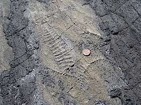
There are no snakes or other reptiles on the Avalon,[50] and while black bears are native to Newfoundland and Labrador, and found throughout the province, they are rarely seen on the Avalon Peninsula.[51] Wolves are technically extinct on the Island but there are reports of migrants from Labrador and wolf-coyote crosses.[52] Coyotes have migrated to the Island of Newfoundland and to the Avalon. Moose, though not native to the Island, are one of the most obvious inhabitants of the East Coast Trail. The tracks of the largest land animal on the Trail are nearly everywhere. Hikers are liable to encounter moose anytime, especially during twilight and early dawn. Hikers will often observe small trees and shrubs missing their growing tips where moose have munched the new growth as they walked along the Trail.[53] Foxes, otters, beavers, Weasels, Snowshoe Hares (called rabbit by the locals),[54] Seals, and Whales, are some of the other mammals that may be seen. Caribou can sometimes be seen in the vicinity of Trepassey, though the herd that frequents the Avalon Wilderness Reserve has dwindled in recent years.[55]
Birds
Along this coastline are some of the greatest seabird hotspots in the world, with thousands of seabirds nesting in the area annually.[56]
Berries on the trail
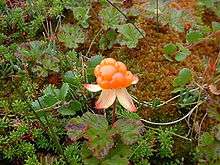
Delicious berries can often be found along the Trail. Bake apples are the first to be found, around July, and are found in the numerous bog that are scattered along the Trail, and particularly along the Cape Spear, and Motion Paths.[57] They are also known as cloudberry.[58] Bake apples are highly prized by Newfoundlanders and are "are confined to drier bogs".[59] Wild strawberries are common in disturbed areas throughout Newfoundland. ... [They produce] small but very sweet berries by July and early August".[60] Then, blueberries and raspberries can be found in August with Deadman's Bay, Blackhead Paths being good sources. Blueberries grow on "low shrubs in woodland clearings, on barrens and burn overs".[61] September is a good month for blackberries, crowberries, and October for cranberries and the closely related marshberries. They both "ripen after the first frost, in late October and November". November is the best month to pick partridgeberries as frost improves their taste.[62] They are also known as mountain cranberry,[63] lingonberry or cowberry.[64][65][66] and are found on barrens throughout Newfoundland.[67]
See also
References
- "Home". www.eastcoasttrail.com. Retrieved 2017-04-05.
- "Best Adventure Destinations for 2012 - National Geographic". 2016-12-14. Retrieved 2017-04-06.
- "East Coast Trail" Rough Guide
- Introduction to Nonprofit Management: Text and Cases, edited by W. Glenn Rowe, Mary Conway Dato-on, p. 356
- ECT Association
- ECTA
- Constitution Ratified September 28, 2016 ECT Constitution
- Masterless men of Newfoundland, Canadian Encyclopaedia
- Town of Portugal Cove-St. Phillips
- "Pouch Cove, East Coast Trail sign protective MOU",Telegram 22 November 2018
- Peter Gard and Bridget Neame Trails of the Avalon, p. 37.
- "Trails", Town of Torbay
- "East Coast Trail Association". Retrieved 2017-04-05.
- "East Coast Trail Association". Retrieved 2017-04-05.
- "East Coast Trail (Logy Bay to Quidi Vidi)", Club Tread
- Grand Concourse map
- Peter Gard and Libby Creelman, "Map", Hiking the East Coast Trail: Fort Amherst to Petty Harbour-Maddox Cove. St John's, NL: East Coast Trail Association, 2008
- Explore Newfoundland and Labrador
- "NCC protects 98 hectares in Freshwater Bay", NCC
- "East Coast Trail Association". Retrieved 2017-04-05.
- Peter Gard and Libby Creelman, "Map", Hiking the East Coast Trail: Fort Amherst to Petty Harbour-Maddox Cove. St John's, NL: East Coast Trail Association, 2008
- "East Coast Trail Association". Retrieved 2017-04-05.
- Government of Newfoundland and Labrador
- Peter Gard and Bridget Neame Trails of the Avalon, pp. 75-6.
- "Discover The East Coast Trail"August 10, 2018 Newfoundland Herald
- "East Coast Trail Association". Retrieved 2017-04-05.
- Government of Newfoundland and Labrador
- "East Coast Trail Association". Retrieved 2017-04-05.
- [Peter Gard and Bridget Neame Trails of the Avalon, pp. 81-4]
- "East Coast Trail Association". Retrieved 2017-04-05.
- Peter Gard and Bridget Neame Trails of the Avalon, pp. 87,85.
- "East Coast Trail Association". Retrieved 2017-04-05.
- "East Coast Trail - Brigus Head Path" Government of Newfoundland and Labrador
- "East Coast Trail Association". Retrieved 2017-04-05.
- Ann Britton Campbell, "Top 7 walk-worthy sights on Newfoundland and Labrador’s East Coast Trail", 'Westjet Magazine, 7 August 2012.
- "East Coast Trail Association". Retrieved 2017-04-05.
- "East Coast Trail - Spurwink Island Path", Government of Newfoundland and Labrador
- "Environmental assessment bulletin", Government of Newfoundland and Labrador
- "Environmental assessment bulletin", Government of Newfoundland and Labrador
- "Wreck Path", Wikiloc
- Peter Gard and Bridget Neame Trails of the Avalon
- "Clam Cove and Telegraph Paths" Wkiloc
- Go take a Hike
- "Mistaken Point Ecological Reserve". NL Department of Environment and Conservation. Government of Newfoundland and Labrador. Retrieved 17 July 2016.
- Metrobus
- Local Transportation, The Government of Newfoundland; the ECTThruhike page also has more information re other operators
- Hop on Hop Off
- "Avalon Peninsula Natural Area",Nature Conservancy of Canada.
- "Logy Bay-Middle Cove-Outer Cove". Canadian Climate Normals 1981–2010 (in English and French). Environment Canada. Retrieved September 13, 2015.
- Species at Risk Public Registry, Government of Canada
- "Black Bears", Fisheries and Land Resources, Government of Newfoundland and Labrador
- "Bonavista, N.L., 'coyote' was really wolf, tests confirm", CBC News
- Patrick M. Ryan, "Two Dozen and Ten Talesof theEast Coast Trail", Memorial University of Newfoundland and Labrador
- Government of Newfoundland and Labrador, Department of Fisheries and Land Resources
- "A Report on the Newfoundland Cariboo", Government of Newfoundland, Environment and Conservation
- "Avalon Peninsula Natural Area",Nature Conservancy of Canada.
- Newfoundsander
- "BSBI List 2007". Botanical Society of Britain and Ireland. Archived from the original (xls) on 2014-10-23. Retrieved 2014-10-17.
- Todd Boland, "Edible Plants of Newfoundland", Botanical Garden, Memorial University of Newfoundland and Labrador
- Todd Boland, "Edible Plants of Newfoundland"
- Todd Boland, "Edible Plants of Newfoundland",
- Newfoundsander
- Todd Boland "Edible Plants of Newfoundland"
- Gray's Manual of Botany: Asa Gray
- Interactive Flora of Northwest Europe
- "Vaccinium vitis-idaea". Natural Resources Conservation Service PLANTS Database. USDA.
- Todd Boland, "Edible Plants of Newfoundland"; Newfoundsander
External links
| Wikimedia Commons has media related to East Coast Trail, Newfoundland. |