Eagleville, Mineral County, Nevada
Eagleville is a former populated place in Mineral County, Nevada that is now a ghost town.
Eagleville | |
|---|---|
 Eagleville Location within the state of Nevada  Eagleville Eagleville (the United States) | |
| Coordinates: 39°01′34″N 118°15′10″W | |
| Country | United States |
| State | Nevada |
| County | Mineral |
| Elevation | 5,561 ft (1,695 m) |
| Time zone | UTC-8 (Pacific (PST)) |
| • Summer (DST) | UTC-7 (PDT) |
| GNIS feature ID | 854763[1] |
History
Mineral deposits were first discovered in the area by the 1870s.[2] Eagleville had some Mormon residents in the 1870s.[lower-alpha 1] Eagleville's post office was in operation from June 1889 until March 1913.[4] Baryte within limestone in large quantities were examined in Eagleville in 1899, but its distance from the railroad deemed it as unprofitable to work.
The Eagleville area produced small amounts of gold and silver in 1905 and 1908[5]-1909.[6][7] The Jim Barron mine (also known as the Baron mine) was in operation near Eagleville in the 1910s.[8] The Golden Extension Mine was in production from 1915 to 1918.[5]
Eagleville, Churchill County
After Eagleville declined in Mineral County, in the 1910s[9] and the 1950s it was noted that a small village was present with the same name in nearby Churchill County.[10] The site is 10.5 miles (16.9 km) northeast of Rawhide[10], 10 miles (16 km) southeast of Frenchman's Station.[11]
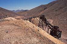 A trestle and ore bin at the Eagleville Mine, Mineral County, Nevada. Mount Annie and Mount Anna are in the distance.
Notes
- "... trade with nearby mining communities, Mormons in Panaca and Eagleville, Nevada, contributed conspicuous sums of gold dust and coin in the 1870s."[3]
References
- "Eagleville (historical)". Geographic Names Information System. United States Geological Survey.
- Mineral Resource Inventory--Bureau of Land Management, Carson City District, Nevada, pp. 75-77 (January 1990)
- Journal of Mormon History. Mormon History Association. 1979. p. 15. Retrieved September 22, 2017.
- U.S. Geological Survey Geographic Names Information System: Eagleville Post Office (historical)
- Lincoln, Francis Church (1923). "Mining districts and mineral resources of Nevada". p. 2. Retrieved April 28, 2020. Note that this reference (Lincoln 1923) states that Fallon, Nevada is 64 miles to the northwest of Eagleville, which disagrees with Murgbarger's statement that Eagleville, Churchill County is 52 miles southeast of Fallon. Also, this reference states that the Eagleville district is in Churchill County, though the GNIS Eagleville Mining District cites this reference (Lincoln 1923) but states that the district is in Mineral County.
- "Camp of Eagleville is Again Shipping Golden Ore". Reno Evening Gazette. August 9, 1909. Retrieved April 30, 2020.
- Paher, Stanley W. (1970). Nevada Ghost Towns and Mining Camps. Howell North. p. 456.
- The Salt Lake Mining Review. 1915. p. 26. Retrieved September 22, 2017.
- Hasch, Vera E.; Cleator, Cora M.; Bray, Florence L. (1911–1912). "The Significance of the Nomenclature in Churchill, Douglas, Lyon, Ormsby and Storey Counties". Third Biennal Report of the Nevada Historical Society (Report). Retrieved May 16, 2020.CS1 maint: date format (link)
- U.S. Geological Survey Geographic Names Information System: Eagleville (historical) (Churchill County)The Churchill County location was added to the GNIS database in 1958 at the request of K.V. Steinbrugge for publication purposes. Steinbrugge was a structural engineer who wrote about the 1954 earthquake near Fairview, Nevada.
- Murbarger, Nell. Ghosts of the Glory Trail. Desert Magazine Press. p. 258. ISBN 978-0913814598. Retrieved April 25, 2020.
External links
- Eagleville. Forgottennevada.org.
- Eagleville. Ghosttowns.com.
Municipalities and communities of Mineral County, Nevada, United States | ||
|---|---|---|
| CDPs | 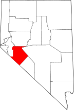 Mineral County map | |
| Unincorporated community | ||
| Indian reservation | ||
| Ghost towns | ||