Drury, New Zealand
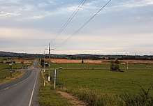
Drury is a rural town near Auckland, in northern New Zealand. Located 36 kilometres to the south of Auckland CBD, under authority of the Auckland Council. Drury lies at the southern border of the Auckland metropolitan area, 12 kilometres to the northeast of Pukekohe, close to the Papakura Channel, an arm of the Manukau Harbour.[2]
Drury | |
|---|---|
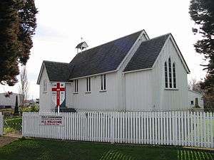 St John's Church, Drury | |
 Drury  Drury | |
| Coordinates: 37°06′S 174°57′E | |
| Country | New Zealand |
| Local authority | Auckland Council |
| Electoral ward | Franklin |
| Population (2013)[1] | |
| • Total | 3,531 |
| Hingaia | Rosehill | Opaheke |
| Runciman |
|
Ponga |
| Ramarama | Ramarama | Ararimu |
Name
Drury is named after Commander Byron Drury, captain of HMS Pandora, who surveyed the Manukau Harbour in 1853.[3]
History

Coal mining was a significant early industry established in Drury during the 1850s, and saw the formation of the Waihoihoi Mining and Coal Company in 1859.[4] Continued success with coal mining led to the opening of one of New Zealand's earliest tramways by the company in 1862, consisting of 4ft 8in gauge track with a length of 5.2km, whereby coal was transported to Slippery Creek for shipment to Onehunga.[5] Another early industry seen in Drury was that of an extensive brick and pottery works, linked to a nearby quarry by a tram line at the foot of the Drury Hills.[6] The brick and pottery industry in Drury appears to have operated until at least 1928.[7]
Drury was a significant staging area for British soldiers during the New Zealand Wars, who established a camp in the village under the command of General Duncan Cameron. These soldiers also helped to construct an extension to the Great South Road south to the Mangatawhiri Stream.
During the major reform of local government in 1989, Drury was included in the Auckland Region and made up the southern edge of the Papakura District, along with a certain extent of the eastern surrounding rural areas, previously known as Franklin County. Drury was until recently a relatively small semi-rural area nestling at the foot of the low-lying Bombay Hills. Urban spread of Auckland has rendered it an extreme southern suburb, close to the junction between State Highways 1 and 22, both of which head south towards the Waikato region.
After a review of the Royal Commission on Auckland Governance, the entire Auckland Region was amalgamated into a single city authority, the Auckland Council, in 2010. The Papakura District and Franklin District, and all other territorial authorities in the region were abolished and incorporated into the new council. The town of Drury was included in the Franklin ward, one of the thirteen wards of the council.
Future Growth
Auckland's largest business park, expected to employ 6900 people, is currently under development in the south of Drury. An estimated 2500 homes are also set to be built in the west of Drury, with development already well underway.[8]
People
The Drury population is predominantly European as at 2013, at 85.7 percent. Maori residents make up 12.2 percent of the suburb, and 7.3 percent being of Asian ethnicity. According to the 2013 New Zealand census, (for residents aged 15 years and older) the most common occupational group in Drury is Managers, with an unemployment rate of 5.4 percent.[1]
References
- 2013 Census QuickStats about a place : Drury
- "Drury Travel Guide". Jasons Travel Media.
- Drury from nzhistory.govt.nz
- "Page 3 Advertisements Column 3". New Zealander. 27 July 1859. Retrieved 18 April 2018.
- "COAL MINES". New Zealander. 7 May 1862. Retrieved 18 April 2018.
- "DRURY POTTERY WORKS". Auckland Star. 22 November 1906. Retrieved 18 April 2018.
- "Page 28 Advertisements Column 4". Auckland Star. 13 December 1928. Retrieved 18 April 2018.
- Paul Charman (7 September 2017). "'Unprecedented growth' forecast for Drury". NZ Herald. Retrieved 19 April 2018.
External links
- Drury Village Website
- Papakura District Council
- New Auckland Council
- Photographs of Drury held in Auckland Libraries' heritage collections.