Drahonín
Drahonín is a village and municipality (obec) in Brno-Country District in the South Moravian Region of the Czech Republic.
Drahonín | |
|---|---|
Municipality | |
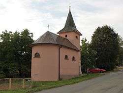 Chapel of Christ the King | |
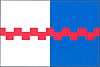 Flag 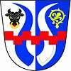 Coat of arms | |
 Drahonín | |
| Coordinates: 49°24′40″N 16°16′22″E | |
| Country | |
| Region | South Moravian |
| District | Brno-Country |
| Area | |
| • Total | 6.68 km2 (2.58 sq mi) |
| Elevation | 517 m (1,696 ft) |
| Population (2006) | |
| • Total | 113 |
| • Density | 17/km2 (44/sq mi) |
| Postal code | 592 61 |
| Website | http://www.drahonin.cz |
The municipality covers an area of 6.68 square kilometres (2.58 sq mi), and has a population of 113 (as at 2 October 2006).
Drahonín lies approximately 35 kilometres (22 mi) north-west of Brno and 153 km (95 mi) south-east of Prague.
This article is issued from Wikipedia. The text is licensed under Creative Commons - Attribution - Sharealike. Additional terms may apply for the media files.