Devilsmother
Devilsmother is a 645-metre-high (2,116 ft) mountain in Connemara, Ireland.
| Devilsmother | |
|---|---|
| Magairlí an Deamhain | |
 | |
| Highest point | |
| Elevation | 645 m (2,116 ft) |
| Prominence | 280 m (920 ft) |
| Listing | Hewitt, Marilyn |
| Coordinates | 53°36′01″N 9°38′17″W |
| Geography | |
 Devilsmother Ireland | |
| Location | Border of County Galway and Mayo, Republic of Ireland |
| Parent range | Partry Mountains |
| OSI/OSNI grid | L915624 |
| Topo map | OSi Discovery 37 |
Geography
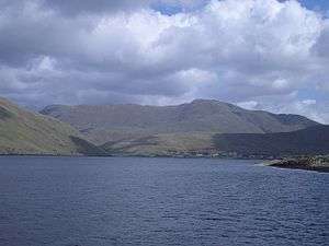
Devilsmother is in the Partry Mountains, at the head of Killary Harbour, overlooking the Western Way long-distance path. It sits on the border between County Galway (to the south) and County Mayo (to the north).
Etymology
The mountain has two Irish language names: Magairlí an Deamhain (meaning "the demon's testicles") and Binn Gharbh (meaning "rough peak").[1] The anglicized spellings Mogarlyandoon and Ben Garrif appear on some historical maps. Originally, it seems that Magairlí an Deamhain was the name of a knobbly ridge north of the summit, while Binn Gharbh applied to the mountain as a whole. The English name Devilsmother may be "a euphemistic false translation" or may be based on an alternative name.[1]
References
- Tempan, Paul. Irish Hill and Mountain Names. MountainViews.ie.
Mountains and hills of Connacht | |||||||
|---|---|---|---|---|---|---|---|
List of mountains in Ireland | |||||||
| Achill Island | 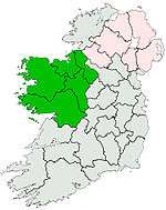 | ||||||
| Dartry Mountains | |||||||
| Maumturks | |||||||
| Mweelrea Mountains |
| ||||||
| Nephin Range | |||||||
| Ox Mountains | |||||||
| Partry Mountains | |||||||
| Sheeffry Range | |||||||
| Twelve Bens |
| ||||||
| Others | |||||||