Dego
Dego (Italian pronunciation: [ˈdeːgo]; Ligurian: O Dê [u ˈdeː]) is a town and comune in the Province of Savona in the region Liguria, in Northwestern Italy.
Dego | |
|---|---|
| Comune di Dego | |
 | |
 Coat of arms | |
Location of Dego 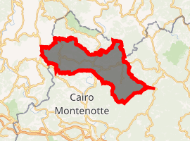
| |
 Dego Location of Dego in Italy 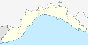 Dego Dego (Liguria) | |
| Coordinates: 44°27′N 8°19′E | |
| Country | Italy |
| Region | Liguria |
| Province | Savona (SV) |
| Frazioni | Bormiola, Botta, Brogi, Cà Bulin-Certosa della Trinità, Chiaffoni, Chiesa Brovida, Costalupara, Girini, Governatori, La Costa, Noceto, Niosa, Piano, Porri, Santa Giulia, Sanvarezzo, Saraffi, Supervia |
| Government | |
| • Mayor | Franco Siri |
| Area | |
| • Total | 67.9 km2 (26.2 sq mi) |
| Elevation | 317 m (1,040 ft) |
| Population | |
| • Total | 1,956 |
| • Density | 29/km2 (75/sq mi) |
| Demonym(s) | Deghesi |
| Time zone | UTC+1 (CET) |
| • Summer (DST) | UTC+2 (CEST) |
| Postal code | 17058 |
| Dialing code | 019 |
| Patron saint | Saint Ambrose |
| Saint day | December 7 |
| Website | Official website |
Geography
The municipality of Dego is located on the northern side of the Ligurian Apennines, on the border with Piedmont; the main population centre is lies at the confluence of the Grillero stream into the Bormida di Spigno.
Dego is about 50 kilometres (31 mi) west of the regional capital Genoa and about 20 kilometres (12 mi) northwest of the provincial seat Savona.
Dego borders the municipalities of Piana Crixia and Spigno Monferrato to the north; Giusvalla to the east; Cairo Montenotte to the south; Castelletto Uzzone and Gottasecca to the west.
References
- "Superficie di Comuni Province e Regioni italiane al 9 ottobre 2011". Istat. Retrieved 16 March 2019.
- All demographics and other statistics: Italian statistical institute Istat.
- "Popolazione Residente al 1° Gennaio 2018". Istat. Retrieved 16 March 2019.
External links
This article is issued from Wikipedia. The text is licensed under Creative Commons - Attribution - Sharealike. Additional terms may apply for the media files.