Deford, Michigan
Deford is an unincorporated community in Tuscola County in the U.S. state of Michigan, located along Bruce/Deckerville Road[1] west of the intersection with Kingston Road (Section 32, North East quarter[1]), north of Kingston and south of Cass City[4] in the southeast corner of Novesta Township.[3] The Deford Post Office with ZIP code 48729 serves the southern portion of the township as well as the northern portion of Kingston Township and areas in the northeast corner of Wells Township.[5]
Deford, Michigan | |
|---|---|
 Deford, Michigan Location within the state of Michigan | |
| Coordinates: 43°30′48″N 83°11′33″W | |
| Country | United States |
| State | Michigan |
| County | Tuscola |
| Township | Novesta Township |
| Settled | 1884 |
| Platted | 1885[1] |
| Government | |
| • Type | None |
| Elevation | 741 ft (226 m) |
| Time zone | UTC-5 (Eastern (EST)) |
| • Summer (DST) | UTC-4 (EDT) |
| ZIP code | 48729 |
| Area code(s) | 989 |
| FIPS code | 26-21360[2] |
| GNIS feature ID | 624510[3] |
History
When the Grand Trunk Western Railroad was built through Deford in 1883, the station was named Bruce after local land owner Elmer Bruce. The community was founded in 1884 by Arthur Newton and named for his friend, Mr. Deford. A post office was also established in 1884.[6] A plat for Deford was filed on July 10, 1885.[1]
Climate
Deford's climate is much like that of Flint, approximately 30 or 40 miles to the southwest. During the winter, Deford faces heavy precipitation due to its location on the snow belt that comes through Michigan. The community is also located in a tornado prone region of the thumb area. The average amount of precipitation that falls over the community is 30.6 inches.[7]
Government
Deford has no government of its own and is governed by Novesta Township.[4]
| District | Number | Officeholder |
|---|---|---|
| U.S. Representative | 5 [8] | Dale E. Kildee |
| State Senate | 31[9] | James A. Barcia |
| State Representative | 84[10] | Terry Brown |
| County Commissioner | 3 | Tom Kern |
| School District | Cass City | Multiple; see article |
Education

Public education is provided by Cass City Public Schools.[11] The Deford Christian Academy is a private school that had a 2007-08 year enrollment of 23.[12]
References
- "DEFORD, VILLAGE OF". Statewide Results for Subdivision Plats. State of Michigan Bureau of Construction Code. 1885-07-10. Retrieved 7 July 2009. In the plated subdivision, Deckerville Road is called Bruce Road.
- "U.S. Census website". United States Census Bureau. Retrieved 2008-01-31.
- U.S. Geological Survey Geographic Names Information System: Deford, Michigan
- J. Shively (September 2007). "Tuscola County Map" (PDF). County Map Series. State of Michigan Department of Information Technology Technology Michigan Center for Geographic Information. Retrieved 2009-07-07.
- 48729 5-Digit ZCTA, 487 3-Digit ZCTA - Reference Map - American FactFinder, U.S. Census Bureau, 2000 census
- Romig, Walter (1986) [1973]. Michigan Place Names. Detroit, Michigan: Wayne State University Press. ISBN 0-8143-1838-X.
- "Deford, Michigan". Weather Underground. 2009.
- "2001 Congressional District Statewide Map" (PDF). Michigan Boundary Maps. State of Michigan Department of Information Technology Technology Michigan Center for Geographic Information. September 2002. Retrieved 2009-07-09.
- "2001 Senate District Statewide Map" (PDF). Michigan Boundary Maps. State of Michigan Department of Information Technology Technology Michigan Center for Geographic Information. May 2002. Retrieved 2009-07-09.
- "Michigan's 110 House Districts 2001 Apportionment Plan" (PDF). Michigan Boundary Maps. State of Michigan Department of Information Technology Technology Michigan Center for Geographic Information. May 2002. Retrieved 2009-07-09.
- J. Shively (March 2008). "Tuscola County Map" (PDF). Michigan School District/County Series. State of Michigan Department of Information Technology Technology Michigan Center for Geographic Information. Retrieved 2009-07-07.
- "Search for Private Schools - School Detail for Deford Christian Academy". National Center for Education Statistics. Retrieved 2009-09-03.
Municipalities and communities of Tuscola County, Michigan, United States | ||
|---|---|---|
| Cities | 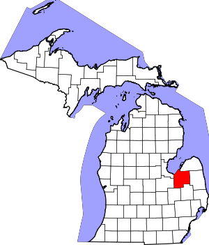 Map of Michigan | |
| Villages | ||
| Charter township | ||
| General law townships | ||
| CDP | ||
| Other unincorporated communities |
| |
| Footnotes | ‡This populated place also has portions in an adjacent county or counties | |