Dalyellup, Western Australia
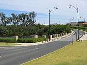
Dalyellup, (pronounced Dal-yellup), is an outer southern suburb of Bunbury, a city in Western Australia, located within the Shire of Capel local government area. The suburb was established in 1999 when the Department of Housing and Works entered into a joint venture with Satterley Property Group to develop Dalyellup Beach Estate, a master-planned community which was expected to yield 3,000 lots by its completion in 2012.
| Dalyellup Bunbury, Western Australia | |||||||||||||||
|---|---|---|---|---|---|---|---|---|---|---|---|---|---|---|---|
 | |||||||||||||||
| Population | 8,998 (2016 census)[1] | ||||||||||||||
| • Density | 1,023/km2 (2,648/sq mi) | ||||||||||||||
| Established | 1999 | ||||||||||||||
| Postcode(s) | 6230 | ||||||||||||||
| Area | 8.8 km2 (3.4 sq mi) | ||||||||||||||
| Location | 11 km (7 mi) SSW of Bunbury | ||||||||||||||
| LGA(s) | Shire of Capel | ||||||||||||||
| State electorate(s) | Collie-Preston | ||||||||||||||
| Federal Division(s) | Forrest | ||||||||||||||
| |||||||||||||||
In the original advertising campaign, Dalyellup was heavily promoted as "A village in the Forest by the Sea". Along this theme the local private Lutheran school is called "Ocean Forest".
Demographics
In the 2006 census, Dalyellup had a population of 3,239.[2] This was an increase from the 2001 census population of 352.[3] The estimated resident population in 2013 was 8,200 according to the Shire of Capel Local Profile[4]. This had increased to the figure of 8,998 reported by the 2016 Census.[5]
According to 2006 statistics, Dalyellup residents had a median age of 29—well below the median of 37 in the Bunbury statistical district[6]—and the median individual income was above-average for the region—$683 per week compared with $492 per week. The population of Dalyellup was predominantly Australian-born—74.9% as at the 2006 census—while significant English (7.2%) and South African (3.6%) minorities were identified. In the 2006 census, 1.73% of residents identified as Indigenous Australians.
The most popular religious affiliations in descending order in the 2006 census were no religion, Anglican, Roman Catholic and Uniting.
Facilities
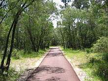
Two large areas within the suburb were set aside as open space - about 100 hectares (250 acres) of pristine tuart forest, officially named the Usher-Dalyellup Regional Park in 2003, with an interpretative walkway leading to Ocean Drive in neighbouring Usher which was opened on 8 October 2007 by the Minister for the South West,[7] and about 120 hectares (297 acres) of dunes and foreshore to the south. A small shopping centre provides for daily needs, but most residents used Bunbury's shopping facilities, until the new shopping centre opened in 2015.[8]
The placement of a larger shopping centre was implemented due to the rapidly increasing population.
Dalyellup also has a large 106-room aged care and community housing project, managed by a local aged care provider. The facility, known as Bethanie Dalyellup, takes over-55's from the Department of Housing. It was officially opened on 10 October 2011 by Western Australian Senator Louise Pratt.[9]
Education
Dalyellup Primary School opened in 2001 in the local shopping centre with 91 students, moving into its own premises in April 2004. The school as at 2007 has a student population of 493 students from Years 1-7, and 179 pre-primary students. The school also serves the neighbouring areas of Gelorup, Stratham and College Grove.[10] The Department of Education and Training has planned a middle school, Dalyellup Secondary College, to cater for years 7-10 from 2009.[11] Dalyellup is within the catchment area for Dalyellup College and is about 6 kilometres (4 mi) from the Bunbury campus of Edith Cowan University. Other schools serving the area include Tuart Forest Primary School. (Ocean Forest Lutheran College closed its doors in December 2017).
Dalyellup Secondary College became Dalyellup College and now since the start of 2009 has been running on two campuses, Harthog Road campus (the old Dalyellup Primary School) accommodates Years K to 4, whilst the newly built Wake Drive campus accommodates years 6 to 11. The school will grow a year at a time such that the present Year 8s in 2009 will be able to complete year 12 at the school. In 2015 the schools separated again creating dedicated Primary to years 6 and Secondary (years 7 to 12) schools.
Transport
Dalyellup is served by the 842 bus route from Park's Centre Shopping Centre, Carey Park and 843 route from Bunbury's central bus station, terminating at the end of Norton Promenade on the coast with a journey time of approximately 35 minutes. The route is operated by TransBunbury for the Public Transport Authority.[12]
Politics
As an emerging suburb, Dalyellup is yet to find a consistent political trend. However, in the two elections held in the 2000s at both state and federal level, its voters have favoured the Liberal Party.
|
|
| ||||||||||||||||||||||||||||||||||||||||||||||||||||||
|
|
| ||||||||||||||||||||||||||||||||||||||||||||||||||||||
Waste dump controversy
In 2009 it was reported that a titanium dioxide refining company called Millennium Inorganic Chemicals had been dumping waste at a Dalyellup site for the past two decades.[13] Residents had been calling for the closure of the site because of concerns over the impact of the waste and its proximity to a residential estate.[14] Two councillors resigned in protest when the Capel council voted to give the waste facility permission to continue dumping waste for another three years,[15] and calls to close the site continued.[16]
References
- Australian Bureau of Statistics (27 June 2017). "Dalyellup (State Suburb)". 2016 Census QuickStats. Retrieved 21 March 2018.

- Australian Bureau of Statistics (25 October 2007). "Dalyellup (State Suburb)". 2006 Census QuickStats. Retrieved 21 October 2007.
- Australian Bureau of Statistics (9 March 2006). "5050513 (Census Collection District)". 2001 Census QuickStats. Retrieved 21 October 2007. Map
- https://web.archive.org/web/20131015195852/http://www.capel.wa.gov.au/Portals/0/Doc/Profile/Shire%20Profile%202013.pdf
- "2016 Census QuickStats". Retrieved 31 January 2020.
- Australian Bureau of Statistics (25 October 2007). "Bunbury (WA) (Statistical District)". 2006 Census QuickStats. Retrieved 21 October 2007.
- South West Development Commission. "Investing in infrastructure and place - Tuart Walk". Archived from the original on 5 October 2007. Retrieved 21 October 2007.
- Department of Housing and Works. "Initiatives - Dalyellup". Perth. Archived from the original on 31 October 2007. Retrieved 2007-10-21.
- http://www.bethanie.com.au/index.php?mact=News,cntnt01,detail,0&cntnt01articleid=193&cntnt01returnid=365 Pratt launches Dalyellup Community Housing
- Department of Education and Training. "Schools Online". Archived from the original on 28 October 2007. Retrieved 21 October 2007.
- Department of Education and Training (18 October 2007). "Proposed Changes and New Schools". Retrieved 21 October 2007.
- "Shire to vote on waste dumping - ABC News (Australian Broadcasting Corporation)". www.abc.net.au. Retrieved 25 November 2009.
- "Govt pressured over Dalyellup toxic waste - ABC News (Australian Broadcasting Corporation)". www.abc.net.au. Retrieved 25 November 2009.
- Towie, Narelle (19 September 2009). "Councillors quit over chemical dumping - PerthNow". www.news.com.au. Archived from the original on 25 September 2009. Retrieved 25 November 2009.
- "Conflict query over waste dump licence - The West Australian". au.news.yahoo.com. Archived from the original on 17 October 2009. Retrieved 25 November 2009.
External links
| Wikimedia Commons has media related to Dalyellup, Western Australia. |
- Dalyellup Beach homepage (Satterley)
- Greater Bunbury Region Scheme (EPA report) contains some information about vegetation in Dalyellup.