Dairi Regency
Dairi Regency is a regency on the northwest shore of Lake Toba in North Sumatra. In 2000, the regency covered an area of 1,927.8 square kilometres (744.3 sq mi) square kilometres and according to the 2010 census had a population of 269,848 people. Its seat is Sidikalang. Immediately to the south are Samosir Regency and Pakpak Bharat Regency.
Dairi Regency | |
|---|---|
 Seal | |
 | |
| Country | Indonesia |
| Province | North Sumatra |
| Regency seat | Sidikalang |
| Government | |
| • Regent | Eddy Keleng Ate Berutu |
| • Vice Regent | Jimmy Andrea Lukita Sihombing |
| • Chairman of Council of Representatives | Sabam Sibarani (Golkar) |
| • Vice Chairmen of Council of Representatives | Alvensius Tondang (PDI-P) and Wanseptember Situmorang (Partai Demokrat) |
| Area | |
| • Total | 1,927.8 km2 (744.3 sq mi) |
| Population (2010 Census) | |
| • Total | 269,848 |
| • Density | 140/km2 (360/sq mi) |
| Time zone | UTC+7 (WIB) |
| Website | www |
Geography and climate
Dairi covers a total area of 1,927.8 square kilometres (744.3 sq mi).[1] It is mostly hills and mountains, averaging 700 to 1,250 metres (2,300 to 4,100 ft) above sea level. It has a tropical rainforest climate, with the heaviest rainfall between September and May.[2]
Dairi is bordered on its north by Southeast Aceh and Karo, to its south by Pakpak Bharat, to its east by Toba Samosir, and to its west by South Aceh.[2]
Demographics

A 2008 estimate by the Dairi government put Dairi's population at 271,983, with a sex ratio of 99.43. Of the population, 39.96% is under the age of 14.[3] At the 2010 Census the population was 269,848.
Administration
Dairi Regency is divided into fifteen districts (kecamatan), tabulated below with their 2010 Census population:[4]
| Name | Population Census 2010[4] |
|---|---|
| Sidikalang | 48,646 |
| Berampu | 7,908 |
| Sitinjo | 11,235 |
| Parbuluan | 20,637 |
| Sumbul | 39,365 |
| Silahi Sabungan | 4,471 |
| Silima Pungga-Pungga | 12,651 |
| Lae Parira | 13,567 |
| Siempat Nempu | 17,979 |
| Siempat Nempu Hulu (Upper Siempat Hulu) | 17,663 |
| Siempat Nempu Hilir (Lower Siempat Hulu) | 10,423 |
| Tiga Lingga | 21,444 |
| Gunung Sitember | 9,090 |
| Pegagan Hilir (Lower Pegagan) | 14,740 |
| Tanah Pinem | 20,234 |
These districts in turn comprise 131 administrative villages (desa and kelurahan).[1]
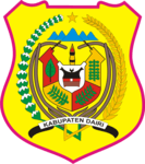
Coat of arms
The coat of arms of Dairi has many connotations. Indonesia's date of independence, 17 August 1945, is indicated by the 17-budded cotton plant on the left side, 8 rattan branches in the center, and 45 seeds of rice on a stalk to the right. The shield in the centre is divided into five, four parts indicating different cash crops important to the area (benzoin resin, coffee, tobacco and patchouli), while the fifth shows a traditional Pakpak Batak house; the house signifies protection. The five point star in the top center signifies the Pancasila-respecting habits of the Dairi people, while the mountains represent tranquility and the chains represent gotong royong, or cooperating and collaborating. The central sharpened bamboo spear represents the Dairi people's struggle for independence.[5]
History

Prior to the arrival of the Dutch East India Company, the people of what is now Dairi lived in traditional adat-regulated communities, with unelected local leaders. After the arrival of the Dutch they established an ethnic-Dutch controleur to be in charge of the Dairi onder afdeling, as well as a native Indonesian demang, or lieutenant. When the Japanese occupied Indonesia beginning in 1942, the Dairi area was also occupied; during this time, local youths were used as forced labour to build the 65 kilometres (40 mi) long Sidikalang road and the Dutch were removed.[6]
After Indonesia's independence, the residents attempted to build a foundation for a new government. However, after the Dutch army recaptured nearby East Sumatra in 1947, they chose a new leader for the Dairi area. Another leader was chosen in 1949; later that year, after the Netherlands and Indonesia signed the, [6]
Economy
Farming is a large business in Dairi. Major crops in Dairi are coffee, both robusta and arabica, corn, and potatoes. Approximately 6,770 tonnes of robusta coffee are produced every year, in addition to 2,639 tonnes of arabica; corn fields take up 63% of suitable farming land.[1] Other minor trades are damar collecting, fish farming, and rattan.[7]
References
- Footnotes
- North Sumatra, Dairi.
- Dairi Government, Geografi.
- Dairi Government, Demografi.
- Biro Pusat Statistik, Jakarta, 2011.
- Dairi Government, Lambang.
- Dairi Government, History.
- Dairi Government, Sosiologi.
- Bibliography
- "Demografi" [Demography] (in Indonesian). Government of Dairi Regency. Retrieved 23 August 2011.
- "Geografi" [Geography] (in Indonesian). Government of Dairi Regency. Retrieved 23 August 2011.
- "Kabupaten Dairi" [Dairi Regency] (in Indonesian). Government of North Sumatra. Archived from the original on 17 February 2009. Retrieved 23 August 2011.
- "Lambang Daerah" [Area Coat of Arms] (in Indonesian). Government of Dairi Regency. Retrieved 23 August 2011.
- "Sejarah" [History] (in Indonesian). Government of Dairi Regency. Retrieved 23 August 2011.
- "Profil Pemerintah Kabupaten Dairi" [Profile of the Dairi Regency Government] (in Indonesian). Government of Dairi Regency. Retrieved 23 August 2011.
- "Sosiologi" [Sociology] (in Indonesian). Government of Dairi Regency. Retrieved 23 August 2011.
| Authority control |
|---|