Dachstein Mountains
The Dachstein Mountains (German: Dachsteingebirge) are a mountain range in the Northern Limestone Alps.
| Dachstein Mountains | |
|---|---|
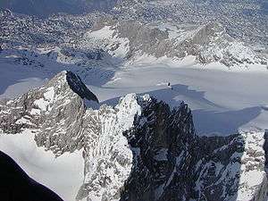 Aerial shot of the Dachstein from ca. 3,600m. Left: the Lower Dachstein: Rear: the Gjaidstein | |
| Highest point | |
| Peak | Hoher Dachstein |
| Elevation | 2,995 m above sea level (AA) |
| Dimensions | |
| Length | 50 km (31 mi) |
| Geography | |
.png) Dachstein Mountains (in red) within the Alps.
The borders of the range according to Alpine Club classification of the Eastern Alps | |
| Country | Austria |
| States | Upper Austria, Styria and Salzburg |
| Range coordinates | 47°31′N 13°40′E |
| Parent range | Northern Limestone Alps |
The term is used by the Austrian Alpine Club in its classification of the Eastern Alps as one of the 24 sub-ranges of the Northern Limestone Alps (AVE No. 14).
The Dachstein range includes:
- The Dachstein Massif proper with its highest peak, the Hoher Dachstein (2,995 m (AA))
- Grimming (2,351 m above sea level (AA)) in the east to the upper Styrian Enns valley
- Sarstein (1,975 m above sea level (AA)) in the north at the other bank of the River Traun
Extent
The Dachstein Mountains are bordered as follows:[1]
- to the northeast by the Totes Gebirge, which is separated by the line from Sankt Agatha on the Hallstättersee – Pötschenhöhe – Bad Aussee – Kainischtraun – Bad Mitterndorf – Klachau – Grimmingbach to the River Enns
- to the south by the Rottenmanner und Wölzer Tauern and the Niedere Tauern, which are separated by the River Enns, roughly from Untergrimming to its confluence with the Weißenbach near Haus im Ennstal
- to the southwest by the Roßbrand in the Salzburg Slate Mountains along the line from Weißenbach – Ramsaubach – Schildlehenbach – Kalte Mandling – Warme Mandling – Marcheggsattel – Fritzbach – Linbach – Neubach to Lungötz in the Lammer valley
- to the west the Lammer valley forms the boundary of the mountains with the Tennengebirge
- to the northwest the Salzkammergut Mountains are separated by a line from Rußbach – Gschütt Pass – Gosaubach – Hallstätter See to Sankt Agatha
Divisions
The two individual peaks of Grimming and Sarstein were counted as part of the Dachstein range because both have been broken off the Dachstein limestone block, even though they are quite separate from a hydrographic and orographic perspective. This classification appeared as early as 1924 in the Moriggl Division of the Alps.
The dividing lines are:
- Hallstättersee and Koppentraun to Sarstein
- from Bad Mitterndorf on the Salzabach including the Salza Reservoir to Grimming – here the Dachstein Glacier has carved out another valley which is drained by the Kainischtraun to the north and the Grimmingbach to the south, and which forms the natural landscape division with the Totes Gebirge. In between the Salza crosses the valley in a curious way, and forms a narrow gorge (Salzaschlucht) between Grimming and Kemetgebirge, the eastern edge of the Dachstein plateau.
Climate
| Climate data for Krippenstein | |||||||||||||
|---|---|---|---|---|---|---|---|---|---|---|---|---|---|
| Month | Jan | Feb | Mar | Apr | May | Jun | Jul | Aug | Sep | Oct | Nov | Dec | Year |
| Record high °C (°F) | 13.5 (56.3) |
12.2 (54.0) |
12.2 (54.0) |
14.2 (57.6) |
18.7 (65.7) |
24.1 (75.4) |
26.0 (78.8) |
25.3 (77.5) |
24.0 (75.2) |
18.5 (65.3) |
14.5 (58.1) |
11.6 (52.9) |
26.0 (78.8) |
| Average high °C (°F) | −2.0 (28.4) |
−2.6 (27.3) |
−0.8 (30.6) |
1.7 (35.1) |
6.8 (44.2) |
9.7 (49.5) |
12.2 (54.0) |
12.7 (54.9) |
9.4 (48.9) |
6.4 (43.5) |
1.0 (33.8) |
−1.0 (30.2) |
4.5 (40.0) |
| Daily mean °C (°F) | −5.4 (22.3) |
−6.1 (21.0) |
−4.4 (24.1) |
−1.9 (28.6) |
3.3 (37.9) |
5.9 (42.6) |
8.4 (47.1) |
8.9 (48.0) |
5.7 (42.3) |
2.8 (37.0) |
−2.4 (27.7) |
−4.3 (24.3) |
0.9 (33.6) |
| Average low °C (°F) | −8.2 (17.2) |
−8.8 (16.2) |
−6.9 (19.6) |
−4.4 (24.1) |
0.6 (33.1) |
3.1 (37.6) |
5.5 (41.9) |
6.0 (42.8) |
3.0 (37.4) |
0.2 (32.4) |
−5.1 (22.8) |
−7.0 (19.4) |
−1.8 (28.7) |
| Record low °C (°F) | −28.5 (−19.3) |
−24.0 (−11.2) |
−25.2 (−13.4) |
−16.0 (3.2) |
−11.0 (12.2) |
−5.8 (21.6) |
−3.2 (26.2) |
−7.0 (19.4) |
−7.2 (19.0) |
−15.0 (5.0) |
−20.0 (−4.0) |
−24.0 (−11.2) |
−28.5 (−19.3) |
| Average precipitation mm (inches) | 112.5 (4.43) |
110.1 (4.33) |
160.3 (6.31) |
132.7 (5.22) |
140.4 (5.53) |
219.3 (8.63) |
257.8 (10.15) |
211.3 (8.32) |
155.7 (6.13) |
104.1 (4.10) |
124.9 (4.92) |
123.7 (4.87) |
1,852.8 (72.94) |
| Average snowfall cm (inches) | 124.5 (49.0) |
142.8 (56.2) |
224.1 (88.2) |
109.2 (43.0) |
41.1 (16.2) |
16.6 (6.5) |
3.1 (1.2) |
6.9 (2.7) |
23.9 (9.4) |
39.3 (15.5) |
101.7 (40.0) |
138.6 (54.6) |
971.8 (382.5) |
| Average precipitation days (≥ 1 mm) | 12.0 | 12.1 | 14.5 | 13.1 | 13.3 | 18.1 | 17.5 | 15.4 | 12.8 | 10.4 | 12.6 | 12.9 | 164.7 |
| Average snowy days (≥ 1 cm) | 31.0 | 28.3 | 31.0 | 30.0 | 28.0 | 12.4 | 2.5 | 1.5 | 5.9 | 11.9 | 24.8 | 30.7 | 238 |
| Average relative humidity (%) (at 0700) | 68.9 | 74.3 | 77.9 | 81.4 | 77.1 | 80.6 | 78.8 | 76.2 | 77.3 | 68.6 | 72.0 | 70.7 | 75.3 |
| Mean monthly sunshine hours | 114.3 | 125.7 | 143.6 | 145.4 | 204.7 | 173.2 | 193.4 | 205.2 | 168.4 | 166.2 | 102.9 | 98.5 | 1,841.5 |
| Percent possible sunshine | 43.3 | 44.0 | 39.1 | 37.0 | 46.2 | 38.4 | 42.1 | 48.2 | 45.4 | 50.6 | 39.0 | 39.2 | 42.7 |
| Source: zamg.ac.at | |||||||||||||
References
External links
![]()
This article is issued from Wikipedia. The text is licensed under Creative Commons - Attribution - Sharealike. Additional terms may apply for the media files.