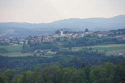
Sankt Agatha
Sankt Agatha is a municipality in the district of Grieskirchen in the Austrian state of Upper Austria.
Sankt Agatha | |
|---|---|
 | |
 Coat of arms | |
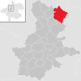 Location in the district | |
 Sankt Agatha Location within Austria | |
| Coordinates: 48°23′10″N 13°52′44″E | |
| Country | Austria |
| State | Upper Austria |
| District | Grieskirchen |
| Government | |
| • Mayor | Franz Weissenböck (ÖVP) |
| Area | |
| • Total | 31.78 km2 (12.27 sq mi) |
| Elevation | 603 m (1,978 ft) |
| Population (2018-01-01)[2] | |
| • Total | 2,116 |
| • Density | 67/km2 (170/sq mi) |
| Time zone | UTC+1 (CET) |
| • Summer (DST) | UTC+2 (CEST) |
| Postal code | 4084 |
| Area code | 07277 |
| Vehicle registration | GR |
| Website | www.st-agatha.at |
Geography
Sankt Agatha lies in the Hausruckviertel. About 30 percent of the municipality is forest, and 65 percent is farmland.
References
- "Dauersiedlungsraum der Gemeinden Politischen Bezirke und Bundesländer - Gebietsstand 1.1.2018". Statistics Austria. Retrieved 10 March 2019.
- "Einwohnerzahl 1.1.2018 nach Gemeinden mit Status, Gebietsstand 1.1.2018". Statistics Austria. Retrieved 9 March 2019.
| Wikimedia Commons has media related to Sankt Agatha. |
This article is issued from Wikipedia. The text is licensed under Creative Commons - Attribution - Sharealike. Additional terms may apply for the media files.