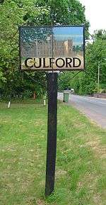
Culford
Culford is a small village about 4 miles (6 km) north of Bury St Edmunds and 62 miles (100 km) north east of London in the West Suffolk district of Suffolk, England.
| Culford | |
|---|---|
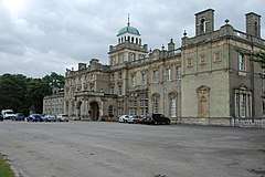 Culford School | |
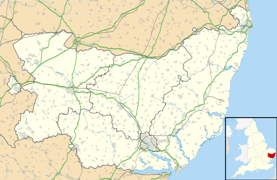 Culford Location within Suffolk | |
| Area | 3.48 sq mi (9.0 km2) |
| Population | 578 (2011) [1] |
| • Density | 166/sq mi (64/km2) |
| District | |
| Shire county | |
| Region | |
| Country | England |
| Sovereign state | United Kingdom |
| Post town | Bury St Edmunds |
| Postcode district | IP28 |
| Dialling code | 01284 |
| UK Parliament | |
The village's name is derived from Cula's Ford.[2]
The village is mentioned as Culeforde in the S1225 charter of 1040 AD where Thurketel grants the lands to Bury St Edmunds Abbey. The Domesday Book records the population of Culford in 1086 to be 32 households.[3] According to the 2001 census the parish had a population of 620, decreasing to 578 at the 2011 Census.[1]
The main village developed along a straight road called "The Street" and there are also some smaller residential areas in Culford, like Benyon gardens, a complex of small lanes. Most of the houses in central Culford are pre-war while those at the edges of the village are post-war and later. The village also encompasses the hamlets of Culford Heath and Chimney Mills.[4]
Culford is home to Culford School, a public school and a member of the Methodist Schools Foundation. The school occupies a former stately home in Culford Park, rebuilt in 1796 for the Cornwallis family.
Culford's Public House, The White Hart, (now known as Benyon Lodge) was closed in December 1840 by Richard Benyon, owner of the Culford Estate between 1824 and 1883, because he regarded it as "a scene of moral debauchery".[5]
The first mention of a postal service in Culford is in July 1852, when a type of postmark known as an undated circle was issued. The post office closed in January 1990 and has since been turned into Culford Day nursery.
Population change
| Population growth in Culford from 1801 to 1891 | ||||||||||
|---|---|---|---|---|---|---|---|---|---|---|
| Year | 1801 | 1811 | 1821 | 1831 | 1841 | 1851 | 1881 | 1891 | ||
| Population | 244 | 239 | 291 | 327 | 352 | 348 | 299 | 364 | ||
| Number of Houses | - | - | - | 55 | 70 | 67 | 73 | 78 | ||
| Source: A Vision of Britain Through Time[6]NOMIS[7] | ||||||||||
| Population growth in Culford from 1901 to 2001 | ||||||||||
|---|---|---|---|---|---|---|---|---|---|---|
| Year | 1901 | 1911 | 1921 | 1931 | 1951 | 1961 | 2001 | 2011 | ||
| Population | 313 | 325 | 284 | 286 | 286 | 286 | 620 | 578 | ||
| Number of Houses | 78 | - | 78 | 76 | 89 | 96 | 163 | 184 | ||
| Source: A Vision of Britain Through Time & NOMIS[6] | ||||||||||
Governance
Culford lies in the West Suffolk District of the shire county of Suffolk. The four tiers of government & their respective representatives are:[8]
- West Suffolk Parliamentary Constituency Matthew Hancock[9]
- Suffolk County Council Thingoe North Division, Beccy Hopfensperger[10]
- West Suffolk District Council Risby Ward, Susan Glossop[11]
- Culford, West Stow and Wordwell Parish Council
Culford, West Stow and Wordwell Parish Councill has 7 elected members, 4 for Culford, 2 for West Stow and 1 for Wordwell.[12]
In terms of community planning the parish does not currently have a Parish Plan or Village Design Statement.
Notable Residents
- Sir Nathaniel Bacon KB Painter
- Richard Benyon De Beauvoir Politician, philanthropist, and High Sheriff of Berkshire
- Earl Cornwallis Aristocratic family and politicians
- George Cadogan, 5th Earl Cadogan
- Gerald Cadogan, 6th Earl Cadogan
- Henry Cadogan, Viscount Chelsea
References
- "Culford - Nomis - Official Labour Market Statistics". www.nomisweb.co.uk. Retrieved 8 June 2019.
- Rye, James. (1997). A popular guide to Suffolk place-names. Dereham: Lark's Press. ISBN 0948400552. OCLC 40839119.
- "Culford | Domesday Book". opendomesday.org. Retrieved 8 June 2019.
- "St Edmundsbury Local History - Water Mills along the River Lark". www.stedmundsburychronicle.co.uk. Retrieved 20 June 2019.
- Isabel Jones (Spring 2007). "Landowners and their motives for change at the Suffolk village of Culford between 1793 and 1903". The Historian (93): 34–37.
- "A Vision of Britain Through Time". University of Portsmouth & others. Retrieved 11 June 2014.
- "Custom report - Nomis - Official Labour Market Statistics". www.nomisweb.co.uk. Retrieved 29 March 2020.
- "Representatives of Culford". Retrieved 11 June 2014.
- "The Rt Hon Matt Hancock MP - Secretary of State for Health and Social Care".
- "Councillor details – Suffolk County Councillor Beccy Hopfensperger - Cabinet Member for Adult Care".
- "Councillor details - Councillor Susan Glossop - Portfolio Holder for Growth". democracy.westsuffolk.gov.uk. Retrieved 8 June 2019.
- "Parish Council". culfordweststowandwordwell.suffolk.cloud. Retrieved 8 June 2019.
Location
Places adjacent to Culford | |
|---|---|
External links

- Culford in the Domesday Book
- Culford Village Website
- Parish Council Website
| Boroughs or districts |
|
|---|---|
| Major settlements |
|
| Topics | |