Crocker Range
Crocker Range (Malay: Banjaran Crocker) is a mountain range in West Coast Division of Sabah, Malaysia that separates the west and east coast of Sabah. At an average height of 1,800 metres (5,900 ft), it is the highest mountain range in the state with the range is named after the British administrator in North Borneo, William Maunder Crocker.[1][2][3]
| Crocker Range | |
|---|---|
 Crocker Range as seen from Ranau–Tamparuli Road. | |
| Highest point | |
| Peak | Mount Kinabalu |
| Elevation | 4,095 m (13,435 ft) |
| Coordinates | 5°45′N 116°30′E |
| Naming | |
| Native name | Banjaran Crocker |
| Geography | |
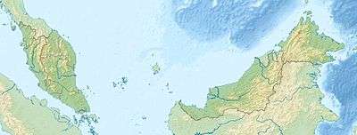 Crocker Range Map showing location of Crocker Range within Malaysia. | |
| Country | |
| State | |
| Region | West Coast Division |
| District | Beaufort, Keningau, Papar, Penampang, Ranau, Tambunan, Tenom and Tuaran |
Geology
The range is made up of uplifted and folded sedimentary rocks consisted of weathered soft sandstones and shales.[4][5] The highest point is Mount Alab at 1,964 metres (6,444 ft) located outside the protected park area.[6][7] Most of the park boundary lies above 300 metres (980 ft) with its lowlands used for cash crops and paddy field.[7] On the east of the range located the Tambunan Valley at 800 metres (2,600 ft) which are mainly terraced paddy fields and groves of bamboos border the north-eastern part of the protected park.[7] The park area is important as a water catchment to supply water into various river in the west coast and interior districts of Sabah including Papar River, Kimanis River, Bongawan River, Membakut River, Padas River and Melalap River that flow west to the park while the Pegalan River, Pampang River, Apin-Apin River, Tendulu River, Melalap River, Liawan River and Tikalod River flow the opposite direction.[7]
History
The area surrounding Mount Kinabalu has been a state park since 1964 and was the country's first World Heritage Site.[8] Part of the range has been gazetted for protection as Crocker Range National Park since 1984.[9] Through the Bornean Biodiversity and Ecosystems Conservation Programme (BBEC), a technical co-operation existed between the government of Sabah and Japan International Cooperation Agency (JICA) to innovate Community Use Zone (CUZ) concept as a management option to address the issues concerning indigenous communities living and utilising resources within the protected areas.[10] Mount Kinabalu, one of the highest mountains in Southeast Asia, is part of this range. In 2014, the mountain range was recognised as a UNESCO Biosphere Reserve, becoming the second Malaysian site thus designated, after Chini Lake in the Malay Peninsula of Pahang.[11][12][13]
Biodiversity
The Crocker Range Forest Reserve area has a wide ranges of flora and fauna diversity and having the highest diversity of nocturnal insects in all the 20 forest reserves surveyed within the Heart of Borneo area in Sabah and recorded a number of endemic species.[7][14][15]
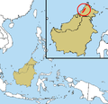 Map of the range.
 The range shrouded by natural fog.
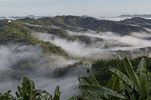
 The range as seen from Ranau District.
 View of the range from Ranau–Tamparuli Road.
 The mountain range as seen from Ling San Pagoda in Tuaran District.
References
- James Blaine Kitzmiller (1982). Anopheline Names: Their Derivations and Histories. Entomological Society of America. p. 143. ISBN 978-0-938522-17-1.
- Frederick Halsey Sheldon; Robert G. Moyle; Jody Kennard (2001). Ornithology of Sabah: history, gazetteer, annotated checklist, and bibliography. American Ornithologists' Union. p. 225. ISBN 978-1-891276-24-8.
- Frédéric Durand; Richard Curtis (28 February 2014). Maps of Malaysia and Borneo: Discovery, Statehood and Progress. Editions Didier Millet. p. 180. ISBN 978-967-10617-3-2.
- F. Tongkul; H. Benedick; F. K. Chang (2006). "Geology of slopes in the Crocker Range, Sabah, Malaysia" (PDF). Nepal Geological Society (34): 73–80. Archived from the original (PDF) on 13 June 2019. Retrieved 13 June 2019 – via Geology Program, School of Science and Technology, Universiti Malaysia Sabah.
- Muhammad Aqeel Ashraf; Radziah Othman; Che Fauziah Ishak (22 September 2017). Soils of Malaysia. CRC Press. p. 56. ISBN 978-1-351-99857-4.
- "Class VI Virgin Jungle Reserve (VJR) [Infrastructure]". Government of Sabah. 2 April 2005. Retrieved 5 July 2019.
- "Crocker Range [Data Zone MY020]". BirdLife International. 2003. Retrieved 27 May 2019. Cite journal requires
|journal=(help) - Yassin Miki; Daring Laban; Nasrulhakim Maidin; Tengku Zainal Adlin; Maklarin Lakim (19 November 2014). "Crocker Range Park: Community Use Zone (CUZ)" (PDF). Sabah Parks: 11. Archived from the original (PDF) on 27 May 2019. Retrieved 27 May 2019 – via Satoyama Initiative, Ministry of the Environment (Japan).
- "Protected Areas of Sabah". Sabah Parks. Archived from the original on 27 May 2019. Retrieved 27 May 2019.
- Ludi Apin; Yassin Miki (15 November 2013). "Community Use Zone of Crocker Range Park, Sabah, Malaysia" (PDF). Sabah Parks. Archived from the original (PDF) on 27 May 2019. Retrieved 27 May 2019 – via Ministry of the Environment (Japan).
- "Sabah's Crocker Range recognised as biosphere reserve by Unesco". Bernama. The Malay Mail. 13 June 2014. Retrieved 27 May 2019.
- Muguntan Vanar (17 June 2014). "Sabah's Crocker Range approved as biosphere reserve under Unesco". The Star. Retrieved 27 May 2019.
- "Crocker Range". Man and the Biosphere Programme, UNESCO. 2014. Archived from the original on 27 May 2019. Retrieved 27 May 2019.
- Arthur Y. C. Chung; Steven Bosuang; Richard Majapun; Reuben Nilus (15 October 2016). "Diversity and Geographical Ranges of Insects in Crocker Range Forest Reserve, Sabah, Malaysia". Journal of Tropical Biology & Conservation. Retrieved 27 May 2019 – via Universiti Malaysia Sabah.
- Monica Suleiman; Dunstan Polus Masundang; Hiroyuki Akiyama (11 October 2017). "The Mosses of Crocker Range Park, Malaysian Borneo". doi:10.3897/phytokeys.88.14674. PMC 5672137 – via PhytoKeys. Cite journal requires
|journal=(help)
External links
