Courtown
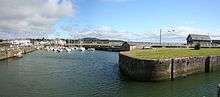
Courtown (Irish: Baile na Cúirte, meaning "homestead of the court"), is a village which developed after Lord Courtown ordered the construction of a harbour during the Famine years, 1839–1846. The economic boost of the new harbour led to a small village developing with fishing being the primary economy of the village. Courtown is situated on the Irish Sea coast and with the recent development during the Celtic Tiger years, has merged into the adjoining village of Riverchapel. It lies on the R742 regional road.
Courtown Baile na Cúirte | |
|---|---|
Village | |
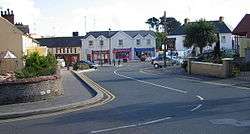 Courtown centre | |
 Courtown Location in Ireland | |
| Coordinates: 52.645°N 6.229°W | |
| Country | Ireland |
| Province | Leinster |
| County | County Wexford |
| Elevation | 6 m (20 ft) |
| Population (2016)[1] | |
| • Total | 3,591 |
| (For census purposes, Courtown is combined with neighbouring Riverchapel and Ardamine) | |
| Irish Grid Reference | T196562 |
Development and amenities

The name Courtown originally applied to a townland in North Wexford, 4 kilometres east of Gorey town. The townland was home to the seat of Lord Courtown during the 18th and 19th centuries. Courtown House was demolished in 1962. The remains of his private church and cemetery can still be seen in the townland. Today it is home to Courtown Golf Club and Kiltennel Church.
In the late 20th and early 21st century, significant urbanisation has taken place, especially in Riverchapel, just south of Courtown Harbour. Large housing estates are now home to commuters working in Dublin. While the population of Courtown is somewhat smaller, the census combines the area of Courtown, Riverchapel and Ardamine. As of the 2006 census the population of this area was 1,421,[2] and had grown to 3,591 by the time of the 2016 census.[3]
Courtown is home to 'The Dinky Take-Away', serving the "best chips in Ireland", as voted on Marty Whelan's morning show on the 2FM radio station. Courtown also has a confectionary shop, ice-cream shop, and hair salons.
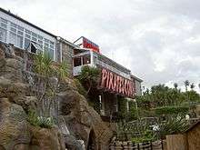
The town features crazy golf, amusement rides, ten-pin bowling, a golf course, as well as a beach and forest park. Courtown is also home to a Class D RNLI inshore lifeboat.
Seal Rescue Ireland (SRI), a charity organisation that works around the clock to rescue, rehabilitate and release native seals found sick, injured or orphaned from across the coast of Ireland is based in Courtown.
.jpg)
Transport
There is a bus once a day (except on Sundays) to and from Gorey, departing in the morning and returning in the afternoon. On Mondays and Saturdays Bus Éireann route 379 operates and continues to Wexford via Curracloe.[4] Route 879 operates on Tuesdays, Thursdays and Fridays. On Wednesdays the service is provided by the Rural Roadrunner bus operated by Wexford Local Development.[5]
The nearest station is Gorey railway station, around 7 kilometres away.
Tourism
As a harbour and seaside village, there is a high tourism rate during the months of the summer (May–August). There are a variety of accommodation types such as bed and breakfasts, guesthouses, and caravan and holiday parks.
History
| Historical population | ||
|---|---|---|
| Year | Pop. | ±% |
| 1841 | 248 | — |
| 1851 | 607 | +144.8% |
| 1861 | 480 | −20.9% |
| 1871 | 613 | +27.7% |
| 1881 | 512 | −16.5% |
| 1891 | 438 | −14.5% |
| 1901 | 462 | +5.5% |
| 1911 | 414 | −10.4% |
| 1926 | 344 | −16.9% |
| 1936 | 316 | −8.1% |
| 1946 | 294 | −7.0% |
| 1951 | 257 | −12.6% |
| 1956 | 411 | +59.9% |
| 1961 | 396 | −3.6% |
| 1966 | 421 | +6.3% |
| 1971 | 291 | −30.9% |
| 1981 | 337 | +15.8% |
| 1986 | 317 | −5.9% |
| 1991 | 343 | +8.2% |
| 1996 | 364 | +6.1% |
| 2002 | 502 | +37.9% |
| 2006 | 1,421 | +183.1% |
| [6][7][8][9][10] | ||
The name 'Courtown' dates back to 1278,[11] but the harbour was not built until the mid 1800s as a response by Lord Courtown to the Great Famine, and cost £25,000 to complete. Courtown was by then already well known for its beaches, but the presence of the harbour made it popular as a fashionable destination, with people from Dublin and the midlands frequenting the village and beaches. Its popularity as a summer holiday resort for Dublin people increased after 1863, when the railway line from Dublin reached nearby Gorey.
References
- "Sapmap Area - Settlements - Courtown Harbour-Riverchapel-Ardamine". Census 2016. Central Statistics Office. April 2016. Retrieved 22 March 2020.
- "Census 2006 – Volume 1 – Population Classified by Area" (PDF). Central Statistics Office Census 2006 Reports. Central Statistics Office Ireland. April 2007. Archived from the original (PDF) on 7 June 2011. Retrieved 19 June 2011.
- "Courtown Harbour - Riverchapel - Ardamine (Ireland) Census Town". citypopulation.de. Retrieved 22 March 2020.
- "Archived copy" (PDF). Archived from the original (PDF) on 12 April 2012. Retrieved 27 February 2012.CS1 maint: archived copy as title (link)
- http://www.journeyplanner.transportforireland.ie
- Census for post 1821 figures. Archived 20 September 2010 at the Wayback Machine
- http://www.histpop.org Archived 2016-05-07 at the Wayback Machine
- "Archived copy". Archived from the original on 17 February 2012. Retrieved 28 April 2014.CS1 maint: archived copy as title (link)
- Lee, JJ (1981). "On the accuracy of the Pre-famine Irish censuses". In Goldstrom, J. M.; Clarkson, L. A. (eds.). Irish Population, Economy, and Society: Essays in Honour of the Late K. H. Connell. Oxford, England: Clarendon Press.
- Mokyr, Joel; O Grada, Cormac (November 1984). "New Developments in Irish Population History, 1700-1850". The Economic History Review. Volume. 37 (4): 473–488. doi:10.1111/j.1468-0289.1984.tb00344.x. hdl:10197/1406. Archived from the original on 4 December 2012.
- http://www.courtownharbour.com/
External links
| Wikimedia Commons has media related to Courtown. |
- www.courtownharbour.com The official website for Courtown Harbour.
- www.courtownrnli.com RNLI Lifeboat Website
- Seal Rescue Ireland
Places in County Wexford | ||
|---|---|---|
| Towns |  | |
| Villages and Townlands |
| |
| ||