Conor Pass
Conor Pass or Connor Pass (Irish: An Chonair)[2] is one of the highest Irish mountain passes served by an asphalted road.[3] It is located on the R560 road in County Kerry, Ireland.
| Conor Pass | |
|---|---|
| An Chonair | |
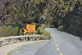 Road warnings on the Conor Pass | |
| Elevation | 456 m (1,496 ft)[1] |
| Traversed by | Road |
| Location | County Kerry, Ireland |
| Range | Mountains of the Central Dingle Peninsula |
| Coordinates | 52°10′55″N 10°12′26″W |
 Location in Ireland | |
Geography
The 456-metre (1,496 ft) high pass connects Dingle, on the south-western end of the Dingle Peninsula, with Brandon Bay and Castlegregory in the north-east.
Access to the pass
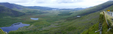
A twisty one-lane asphalted road leads to the pass. The drive, inadvisable in bad weather, is considered one of the most beautiful in Ireland.[4] The scenic road leading to the pass weaves its way around the sharp cliff faces and past high corrie lakes. Vehicles over two tonnes in weight are prohibited from using the road in order to avoid difficulties in passing.
Bicycle ascent to the pass is one of the most famous and difficult climbs in Ireland.[5]
Notes
- Insight Guides: Ireland. Apa Publications. 2014. Retrieved March 6, 2015.
- "An Chonair (Conor Pass)". www.discoverireland.ie. Failte Ireland. Retrieved March 10, 2015.
- "The Conor Pass". Comharchumann Turasóireachta Chorca Dhuibhne. Archived from the original on March 11, 2015. Retrieved March 10, 2015.
- Christi Daugherty and Jack Jewers (2012). Frommer's Ireland 2012. John Wiley & Sons.
- "The Conor Pass". www.kerrycycling.com. Retrieved March 7, 2015.
Bibliography
- Insight Guides: Ireland. Apa Publications. 2014.
See also
External links
![]()