Connecticut Route 130
Route 130 is a state highway in southwestern Connecticut, running from Fairfield to Stratford, generally parallel to I-95.
| ||||
|---|---|---|---|---|
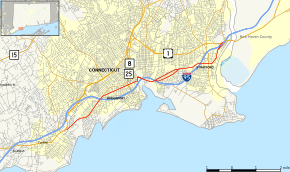 Map of Fairfield County in southwestern Connecticut with Route 130 highlighted in red | ||||
| Route information | ||||
| Maintained by ConnDOT | ||||
| Length | 8.21 mi[1] (13.21 km) | |||
| Existed | 1992–present | |||
| Major junctions | ||||
| West end | ||||
| East end | ||||
| Location | ||||
| Counties | Fairfield | |||
| Highway system | ||||
| ||||

Route description
Route 130 begins at an intersection with US 1 in Fairfield and heads east into Bridgeport. In Bridgeport, it intersects I-95, then passes under Route 8 and I-95 twice without junctions before crossing into Stratford. In Stratford, it passes under I-95 again without a junction before intersecting I-95 a second and ending at another intersection with US 1.[1]
Route 130 is designated the A.W. Penn Memorial Highway from the Fairfield-Bridgeport town line to State Street.[1]
History


In 1922, state roads were given number designations in New England for the first time. Modern Route 130 was originally part of New England Route 1. In 1927, the U.S. Highway system was created and New England Route 1 became part of U.S. Route 1 (US 1). In 1932, an alternate route of US 1 (US 1 Alt. was designated along North Avenue, Boston Avenue, and Barnum Avenue further inland (now modern US 1). In 1963, US 1A in the Bridgeport area was deleted and re-designated as US 1. The original US 1 alignment along Fairfield Avenue, State Street, and Stratford Avenue became unsigned state roads, with designations of SR 771 (Fairfield-Bridgeport) and SR 769 (Bridgeport-Stratford). In 1992, these were re-designated as modern Route 130.[2]
Major intersections

The entire route is in Fairfield County.
| Location | mi[1] | km | Destinations | Notes | |
|---|---|---|---|---|---|
| Fairfield | 0.00 | 0.00 | Former Boston Post Road | ||
| Bridgeport | 1.93 | 3.11 | Exit 25 on I-95 south (Connecticut Turnpike) | ||
| Exit 2 on Routes 25-8 south | |||||
| Pequonnock River bridge | |||||
| 4.18 | 6.73 | ||||
| 4.65 | 7.48 | ||||
| Community of Stratford | 7.06 | 11.36 | |||
| 7.99 | 12.86 | Exit 33 on I-95 north (Connecticut Turnpike) | |||
| 8.21 | 13.21 | Traffic circle; to Route 110 | |||
| 1.000 mi = 1.609 km; 1.000 km = 0.621 mi | |||||