Connecticut Route 127
Route 127 is a state highway in southwestern Connecticut, running entirely from Bridgeport to Trumbull. It serves as a minor arterial, connecting all four major limited access highways in the Bridgeport area.
| ||||
|---|---|---|---|---|
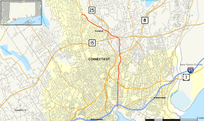 Map of Fairfield County in southwestern Connecticut with Route 127 highlighted in red | ||||
| Route information | ||||
| Maintained by ConnDOT | ||||
| Length | 6.80 mi[1] (10.94 km) | |||
| Existed | 1932–present | |||
| Major junctions | ||||
| South end | ||||
| ||||
| North end | ||||
| Location | ||||
| Counties | Fairfield | |||
| Highway system | ||||
| ||||

Route description
Route 127 begins at an intersection with Route 130 in southeastern Bridgeport and almost immediately intersects I-95. It then heads north, roughly parallel to the Pequonnock River and Route 8, into Trumbull. It intersects Route 8 just north of the Bridgeport-Trumbull town line and continues north, then turns northwest to intersect Route 15 and Route 25 in rapid succession. It then continues northwest to end at an intersection with Route 111 in Trumbull.[1]
History
White Plains Road was laid out to Pulpit Rock, in present-day Trumbull, in 1705.[2] Route 127 was commissioned in 1932 and originally ran from US 1 to its current northern terminus. At an undetermined time before 1978, the southern terminus was truncated to the Huntington Turnpike (SR 730). It was extended south to US 1 in 1992, then further south to Route 130 in 1995.[3]
Major intersections
The entire route is in Fairfield County.
| Location | mi[1] | km | Destinations | Notes | |
|---|---|---|---|---|---|
| Bridgeport | 0.00 | 0.00 | Continues south to a dead end | ||
| 0.10 | 0.16 | Exit 28 on I-95 north (Connecticut Turnpike) | |||
| 1.40 | 2.25 | ||||
| Town of Trumbull | 3.15 | 5.07 | Exit 7 on Route 8 south; Exit 6 on Route 25 south | ||
| 4.20 | 6.76 | Exit 50 on Route 15 south / Merritt Parkway south | |||
| 4.87 | 7.84 | Exit 7B on Route 25 north | |||
| Community of Trumbull | 6.80 | 10.94 | |||
| 1.000 mi = 1.609 km; 1.000 km = 0.621 mi | |||||
References
- Connecticut State Highway Log Archived 2015-07-26 at WebCite
- A History of the Old Town of Stratford and City of Bridgeport, Connecticut, Fairfield County Historical Society, Reverend Samuel Orcutt, 1886, Vol. 2 pg. 1007
- Connecticut Routes, Route 127