Clifton Heights, Pennsylvania
Clifton Heights is a borough in Delaware County, Pennsylvania, United States, located on Darby Creek 5 miles (8 km) west of downtown Philadelphia. As of the 2010 census the population was 6,652.[3]
Clifton Heights, Pennsylvania | |
|---|---|
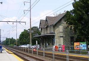 The Clifton-Aldan SEPTA station | |
 Location in Delaware County and the U.S. state of Pennsylvania. | |
 Clifton Heights Location of Clifton Heights in Pennsylvania  Clifton Heights Clifton Heights (the United States) | |
| Coordinates: 39°55′45″N 75°17′45″W | |
| Country | United States |
| State | Pennsylvania |
| County | Delaware |
| Government | |
| • Mayor | Joseph F Lombardo Jr |
| Area | |
| • Total | 0.63 sq mi (1.63 km2) |
| • Land | 0.63 sq mi (1.63 km2) |
| • Water | 0.00 sq mi (0.00 km2) |
| Elevation | 157 ft (48 m) |
| Population (2010) | |
| • Total | 6,652 |
| • Estimate (2018)[2] | 6,681 |
| • Density | 10,638.10/sq mi (4,105.23/km2) |
| Time zone | UTC-5 (EST) |
| • Summer (DST) | UTC-4 (EDT) |
| ZIP code | 19018 |
| Area code(s) | 610 and 484 |
| FIPS code | 42-14264 |
| Website | www |
History
The population of the borough was 1,820 in 1890, 3,155 in 1910, and reached a maximum of 10,268 in 1960.[4]
Clifton Heights is the birthplace of the glam rock band Cinderella.[5] Clifton Heights is the home of Rosati Water Ice, the first Italian ice company in the US.[6]
Geography
Clifton Heights is located in eastern Delaware County at 39°55′45″N 75°17′45″W (39.929062, -75.295760).[7] It is bordered to the northeast by the borough of Lansdowne, to the southeast by the borough of Aldan, and to the west and north by Upper Darby Township. The community of Drexel Hill in Upper Darby Township is to the north of Clifton Heights, across Darby Creek.
The main road through the borough is Baltimore Avenue, which leads northeast into Philadelphia and southwest 5 miles (8 km) to Media.
Clifton Heights is bordered by Darby Creek to the west.
According to the United States Census Bureau, the borough has a total area of 0.62 square miles (1.6 km2), all of it land.[3]
Demographics
| Historical population | |||
|---|---|---|---|
| Census | Pop. | %± | |
| 1890 | 1,820 | — | |
| 1900 | 2,330 | 28.0% | |
| 1910 | 3,155 | 35.4% | |
| 1920 | 3,469 | 10.0% | |
| 1930 | 5,057 | 45.8% | |
| 1940 | 8,162 | 61.4% | |
| 1950 | 8,443 | 3.4% | |
| 1960 | 10,268 | 21.6% | |
| 1970 | 8,348 | −18.7% | |
| 1980 | 7,320 | −12.3% | |
| 1990 | 7,111 | −2.9% | |
| 2000 | 6,779 | −4.7% | |
| 2010 | 6,652 | −1.9% | |
| Est. 2018 | 6,681 | [2] | 0.4% |
| Sources:[4][8] | |||
As of a Census 2015 estimate, the racial makeup of the borough was 67.6% non-Hispanic White, 21.4% African American, 6.9% Asian, 2.1% from other races, and 2.5% from two or more races. Hispanic or Latino of any race were 3.4% of the population. 14.5% of the borough's population was foreign-born .
As of the census[8] of 2000, there were 6,779 people, 2,714 households, and 1,696 families residing in the borough. The population density was 10,882.5 people per square mile (4,221.6/km²). There were 2,883 housing units at an average density of 4,628.2 per square mile (1,795.4/km²). The racial makeup of the borough was 94.22% White, 2.92% African American, 0.06% Native American, 1.50% Asian, 0.38% from other races, and 0.91% from two or more races. Hispanic or Latino of any race were 0.99% of the population.
There were 2,714 households, out of which 31.1% had children under the age of 18 living with them, 42.9% were married couples living together, 14.3% had a female householder with no husband present, and 37.5% were non-families. 31.9% of all households were made up of individuals, and 12.8% had someone living alone who was 65 years of age or older. The average household size was 2.49 and the average family size was 3.20.
In the borough the population was spread out, with 25.8% under the age of 18, 7.9% from 18 to 24, 32.9% from 25 to 44, 18.6% from 45 to 64, and 14.9% who were 65 years of age or older. The median age was 36 years. For every 100 females there were 95.3 males. For every 100 females age 18 and over, there were 90.8 males.
The median income for a household in the borough was $39,291, and the median income for a family was $48,919. Males had a median income of $36,534 versus $32,210 for females. The per capita income for the borough was $20,534. About 11.2% of families and 11.1% of the population were below the poverty line, including 18.1% of those under age 18 and 6.4% of those age 65 or over.
Education
Clifton Heights borough is served by the Upper Darby School District.
- Vinnie Paz, American rapper and record label owner.
- Lena Blackburne, baseball player, manager, inventor
- Eric Brittingham, bassist of the glam rock band Cinderella
- Jim Goad, author
- Tom Keifer, singer-songwriter of the glam rock band Cinderella
- Dan Morgan, professional football player
- Tom Savage, professional football player
References
- "2017 U.S. Gazetteer Files". United States Census Bureau. Retrieved Mar 24, 2019.
- https://www.census.gov/quickfacts/fact/table/cliftonheightsboroughpennsylvania/PST045218
- "Geographic Identifiers: 2010 Demographic Profile Data (G001): Clifton Heights borough, Pennsylvania". U.S. Census Bureau, American Factfinder. Archived from the original on February 13, 2020. Retrieved December 23, 2015.
- "Census of Population and Housing". U.S. Census Bureau. Retrieved 11 December 2013.
- Johnson, Laura. "Cinderella back from the ashes of the 80's". sandiegouniontribune.com. Retrieved 18 November 2017.
- Walton, Timothy (July 23, 2019). "The enduring and sweet legacy of Rosati Water Ice". 6ABC. Retrieved April 10, 2020.
- "US Gazetteer files: 2010, 2000, and 1990". United States Census Bureau. 2011-02-12. Retrieved 2011-04-23.
- "U.S. Census website". United States Census Bureau. Retrieved 2008-01-31.
External links
| Wikivoyage has a travel guide for Clifton Heights. |
Municipalities and communities of Delaware County, Pennsylvania, United States | ||
|---|---|---|
| City | 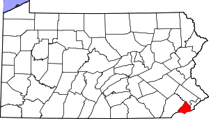 | |
| Boroughs | ||
| Townships | ||
| CDPs | ||
| Unincorporated communities |
| |
| Ghost town | ||
| Footnotes | ‡This populated place also has portions in an adjacent county or counties | |
| Authority control |
|
|---|