Cleveland Shale
The Cleveland Shale, also referred to as the Cleveland Member, is a shale geologic formation in the eastern United States.
| Cleveland Shale Stratigraphic range: Famennian ~360–359 Ma | |
|---|---|
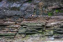 Cleveland Shale (below) and Berea Sandstone of the Bedford Formation at the Great Falls of Tinkers Creek near Bedford, Ohio | |
| Type | Formation |
| Unit of | Ohio Shale |
| Underlies | Bedford Shale |
| Overlies | Chagrin Shale |
| Lithology | |
| Primary | Shale |
| Other | Pyrite |
| Location | |
| Coordinates | 39.4°N 83.6°W |
| Approximate paleocoordinates | 31.3°S 32.2°W |
| Region | |
| Country | |
| Type section | |
| Named for | Cleveland, Ohio |
| Named by | John Strong Newberry |
| Year defined | 1870 |
 Cleveland Shale (the United States) 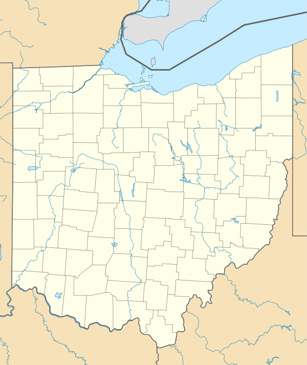 Cleveland Shale (Ohio) | |
Identification and name
The Cleveland Shale was identified in 1870 and named for the city of Cleveland, Ohio. John Strong Newberry, director of the Ohio State Geological Survey, first identified the formation in 1870.[1] He called it the "Cleveland Shale" and designated its type locality at Doan Brook[2] near Cleveland.[1] Details of the type locality and of stratigraphic nomenclature for this unit as used by the U.S. Geological Survey are available on-line at the National Geologic Map Database.[3]
Description
The primary minerals in the Cleveland Shale are chlorite, illite, pyrite, and quartz.[4][lower-alpha 1] Underground, the Cleveland Shale is black,[5][6][7][8] dull grayish-black,[9] bluish-black, or brownish-black[4] in color. In exposed outcrops, it weathers to red,[9] reddish-brown,[2] or medium brown.[4] Highly weathered rock turns gray.[2][4] It is fairly fissile,[6][5][7] breaking into thin, irregularly shaped sheets[10] or flakes[4] that occasionally display crystals of pickeringite.[2] Relieved of stress once exposed, the Cleveland Shale is nonplastic[4] and can appear as if fragmented into blocks due to jointing.[5]
Pyrite basal boundary
There is a sharp and clear distinction between the Cleveland Shale and underlying Chagrin Shale.[2][10] At the very bottom of the Cleveland Shale there is a thin, discontinuous layer of pyrite.[5][lower-alpha 2] This pyrite layer is discontinuous because after this rock was laid down, it was eroded. The erosion increases as one moves south along the valley of the Cuyahoga River and east to the Grand River.[7] Portions of the pyrite layer, known as Skinner's Run Bed,[7] contain fragments of petrified wood and fossilized fish bones worn smooth by the action of water.[5] Above the pyrite layer, a limestone layer is found in west-central (but not eastern) Ohio.[9]
The remainder of the Cleveland Shale generally consists of a relatively hard,[9][lower-alpha 3] organic rich[12] oil shale.[4][8] It has both an upper and lower part.[9]
Lower part
A clay shale,[9] described as bluish or bluish-gray[9] and as olive-black to brownish-black,[13] forms the lower part. The lower part can be anywhere from a few inches to several feet in thickness. Thin beds of gray or brown siltstone, lumps of pyrite, and layers of silica-heavy limestone with cone-in-cone structures are found in the lower part. In eastern Ohio, thin gray veins ("stringers") of siltstone appear.[9] In western Ohio,[8] the Cleveland Shale appears to interbed with the Chagrin Shale below it, erasing the clear boundary between the two rock formations.[9]
Upper part
The upper part of the Cleveland Shale is a black to brownish black[13] silty shale[9] with occasional thin beds of gray shale and siltstone.[5] The upper part is much richer in petroleum[14] and kerogen.[4][lower-alpha 4] When broken open, fresh samples smell like crude oil.[4] Where the upper part is thick,[7] and particularly in northeast Ohio,[10] the shale has a distinctive "rippled" appearance.[7] The upper 10 feet (3.0 m) of the Cleveland Shale contains abundant nodules of phosphate, nodules and bands (extremely thin beds) of pyrite, bands of calcisiltite, and lamination.[13] Almost no concretions are found in the upper part.[4]
Geographic extent

The Cleveland Shale is a shale geologic formation in Ohio in the United States. The Cleveland Shale underlies much of northeast Ohio in beds of varying thickness.
In northeast Ohio, the member does not appear east of the Grand River.[7] Measurements taken in northeast Ohio show the Cleveland Shale to be 7 feet (2.1 m)[7] to 100 feet (30 m) thick.[9] It is thickest around the Rocky River north of Berea, Ohio, and thins to the east, west, and south.[9]
The Cleveland Shale is found in east-central Kentucky. In east-central Kentucky, the Cleveland Shale is more uniform in thickness, ranging from 41.4 to 50.1 feet (12.6 to 15.3 m), and increases in thickness toward the east.[13]
The unit is also present in West Virginia[15] and in southwest Virginia[16], where it is mapped as the Cleveland Member of the Ohio Shale.
Stratigraphic Setting
The Cleveland Shale (or Cleveland Member) is a sub-unit of the Ohio Shale Formation.[7][17] The Chagrin Shale underlies the Cleveland Shale.[18] The Bedford Shale generally overlies the Cleveland Shale, with a sharp distinction between the two. In west-central Ohio, more than 150 feet (46 m) of Bedford Shale may lie above the Cleveland Shale. In places, red and grey shale may intertongue (interlock) with the Cleveland Shale extensively. In far eastern Ohio, the Bedford Shale thins by more than 125 feet (38 m). Where the Cussewago Shale is also present, the Bedford Shale is usually less than 25 feet (7.6 m) and may be locally absent. In some areas, the Cleveland Shale is described as overstepped[7] or unconformably overlaid gradationally by Berea Siltstone and sharply by Berea Sandstone.[10]
It is the regional equivalent of the Hangenberg Sandstone.[19]
Fossils
Exceptional marine animal fossils are found in the formation. The Cleveland Shale is generally considered to be fossil-poor, but there are exceptions. The basal pyrite layer contains petrified wood and fossilized fish bones.[5] The upper part is famous for its extensive and well-preserved fossil Chondrichthyes, Conodonts, Placodermi,[7] Cladoselache,[5] and Palaeoniscinoids.[20] The giant predatory placoderms Dunkleosteus terrelli, Gorgonichthys clarki, Gymnotrachelus hydei, Heintzichthys gouldii, and five subspecies (including the type specimen) of Titanichthys were all discovered in the Cleveland Shale.[21] The Cleveland Shale is classified as a konservatte-lagerstatten, which means it often preserves complete body fossils. Typical early shark preservation includes soft tissue outlines and impressions, fin rays, gill musculature, cartilage, and stomach contents.[22]
Age
The Cleveland Shale is approximately 360 to 358.9 million years old, dating to the latest Devonian; the Famennian stage.[23][24]
Interpretation of depositional environments
The Cleveland Shale is likely the regional expression of the Dasberg event, a major extinction event that occurred near the end of the Devonian period. The Cleveland Shale is interpreted as having accumulated in an anaerobic environment.[6] Evidence exists to suggest that the Cleveland Shale was laid down during the Dasberg event, an Upper Famennian extinction event that devastated land-based flora and marine-based fauna. This led to a significant drop in marine oxygen (an anoxic event) and atmospheric carbon dioxide, and then a brief glaciation. The global environment recovered, only to suffer another extinction, the Hangenberg event, close to the Devonian-Carboniferous boundary.[25] While the Cleveland Shale was being deposited, extensive organic matter from the land was swept into the sea then lying over Ohio.[26] Although there is dispute over how deep this sea was, the Dasberg event meant that oceans could support few to no bottom-dwelling animals. This explains why the Cleveland Shale largely lacks fossils of benthic organisms[27] and has a high carbon content that colors the shale very dark gray to black.[5][28]
The contact between the Chagrin Shale and Cleveland Shale has been described as interbedding. This feature is interpreted as having been caused when two different depositional environments (in this case, the oxygenated sea which laid down the Chagrin Shale and the anaerobic sea rich in organic matter which laid down the Cleveland Shale) moved repeatedly back and forth over the same area.[9] Geologist Horace R. Collins called the boundary area intercalated,[8] but it is unclear what meaning he intended.[lower-alpha 5]
Different hypotheses have been suggested as the cause of the regional, irregular contact between the Cleveland Shale and Bedford Formation. Charles E.B. Conybeare has noted that the Cleveland Shale is siltier in the east and more calcareous in the west. He hypothesized that this indicates that silt flowed into the sea from east to west. Current eroded the Cleveland Shale and then laid down new sediment in the gullies which became the Bedford Formation.[28] Jack C. Pashin and Frank R. Ettensohn proposed a variation on this hypothesis. They note that the region containing the Cleveland Shale was undergoing uplift when the Bedford Formation was being deposited. This likely led to exposure and erosion of the Cleveland Shale, with sediment which became the Bedford Formation filling in these gullies. They also observe that there is evidence of diapirism (the intrusion of deformable Cleveland Shale upward into the more brittle Bedford Formation), as well as intertonguing.[31] Baird et al. note that the Cleveland Shale also tilts downward to the south. They suggest that this caused overstepping, rather than intertonguing.[7]
Economic geology
The high organic content of the Cleveland Shale makes it eminently suitable for the formation of fossil fuels. One 1981 study found that the Cleveland Shale can yield an average of 14 US gallons (53 l; 12 imp gal) of petroleum per 1 short ton (0.91 t) of rock.[32] The Cleveland Shale also contains cannel coal and "true" coal, although neither in great quantity.[4]
See also
- List of fossiliferous stratigraphic units in Ohio
- Marcellus Formation
- Escuminac Formation
- Floresta Formation
- Hunsrück Slate
- Rhynie Chert
- Gogo Formation
- Late Devonian extinction event
References
- Notes
- Quartz particles in the shale range from 2 to 7 micrometres (7.9×10⁻⁵ to 0.000276 in) in size.[4]
- Pyrite forms when organic material falls onto an ocean floor that is anaerobic, has little bottom current, and has extensive deposition of silt and sediment.[7]
- "Hard" is defined as having a compressive strength between 10,000 to 13,000 pounds per square inch (69,000 to 90,000 kPa).[11]
- In a 1981 study of Cleveland Shale samples in central-eastern Kentucky, the upper part of the shale was 11 percent carbon and 1.3 percent hydrogen.[14]
- Intercalation can be used as a synonym for interbedding.[29] The term may also mean the introduction of a new layer between two preexisting layers.[30]
- Citations
- Wilmarth 1938, p. 361.
- Williams 1940, p. 19.
- https://ngmdb.usgs.gov/Geolex/search
- Johnson 1981, p. 171.
- Hannibal & Feldman 1987, p. 404.
- Pashin & Ettensohn 1995, p. 57.
- Baird et al. 2009, p. 10.
- Collins 1979, p. E-10.
- Pepper, DeWitt & Demarest 1954, p. 16.
- Pashin & Ettensohn 1995, p. 51.
- Vyas, Aho & Robl 1981, p. 390.
- Pashin & Ettensohn 1995, p. 50.
- Pollock, Barron & Beard 1981, p. 204.
- Bland, Robl & Koppenaal 1981, p. 188.
- Ryder, R.T., Swezey, C.S., Crangle, R.D., Jr., and Trippi, M.T., 2008, Geologic cross section E-E’ through the central Appalachian Basin from the Findlay Arch, Wood County, Ohio, to the Valley and Ridge Province, Pendleton County, West Virginia: U.S. Geological Survey Scientific Investigations Map SIM-2985, 2 sheets with 48-page pamphlet. http://pubs.er.usgs.gov/publication/sim2985
- Ryder, R.T., Trippi, M.H., and Swezey, C.S., 2015, Geologic cross section I-I’ through the central Appalachian basin from north-central Kentucky to southwestern Virginia: U.S. Geological Survey Scientific Investigations Map SIM-3343, 2 sheets with two pamphlets (41p. and 102p.). http://pubs.er.usgs.gov/publication/sim3343
- Rubel & Coburn 1981, p. 22.
- Pashin & Ettensohn 1995, p. 6.
- Kaiser, Aretz & Becker 2016, p. 404.
- Hansen 2005, pp. 292-293.
- Hansen 2005, pp. 290.
- Various Contributors to the Paleobiology Database. "Fossilworks: Gateway to the Paleobiology Database". Archived from the original on 31 July 2014. Retrieved 22 June 2014.
- Traverse 2008, p. 227.
- Harding, Megan (Spring 1996). "Cleveland Shale and the Age of Fishes". The Explorer. p. 20.
- Baird et al. 2009, pp. 8, 10.
- Kaiser, Aretz & Becker 2016, p. 415.
- Hannibal & Feldman 1987, p. 406.
- Conybeare 1979, pp. 419-420.
- Bates & Jackson 1984, p. 262.
- Neuendorf, Mehl & Jackson 2005, p. 330.
- Pashin & Ettensohn 1995, pp. 50-51.
- Reasoner et al. 1981, p. 12.
Bibliography
- Baird, Gordon C.; Gryta, Jeffry J.; McKenzie, Scott C.; Over, D. Jeffrey; Pulawski, Shirley; Sullivan, Joseph S. (October 2009). "Deconvoluting the End-Devonian Story in the "Oil Lands" of Northwest Pennsylvania". History and Geology of the Oil Regions of Northwestern Pennsylvania. Guidebook for the 74th Annual Field Conference of Pennsylvania Geologists (PDF). Middletown, Pa.: Field Conference of Pennsylvania Geologists, Inc. Retrieved March 22, 2018.CS1 maint: ref=harv (link)
- Bates, Robert L.; Jackson, Julia A. (1984). Dictionary of Geological Terms. New York: Anchor Press. ISBN 9780385181013.CS1 maint: ref=harv (link)
- Bland, Alan E.; Robl, Thomas L.; Koppenaal, D.W. (1981). "Geochemistry of the New Albany, Ohio, and Sunbury Shales in East Central Kentucky". Proceedings, 1981 Eastern Oil Shale Symposium (Report). Lexington, Ky.: Institute for Mining and Minerals Research, University of Kentucky. Retrieved December 12, 2019.CS1 maint: ref=harv (link)
- Collins, Horace R. (1979). "Ohio". The Mississippian and Pennsylvanian (Carboniferous) Systems in the United States. Geological Survey Professional Paper 1110-E. Washington, D.C.: U.S. Government Printing Office.CS1 maint: ref=harv (link)
- Conybeare, Charles Eric Bruce (1979). Lithostratigraphic Analysis of Sedimentary Basins. New York: Academic Press. ISBN 9780121860509.CS1 maint: ref=harv (link)
- Hannibal, Joseph T.; Feldman, Rodney M. (1987). "The Cuyahoga Valley National Recreation Area, Ohio: Devonian and Carboniferous Clastic Rocks". In Biggs, Donald L. (ed.). North-Central Section of the Geological Society of America. Centennial Field Guide. Volume 3. Boulder, Colo.: Geological Society of London. ISBN 9780813754031.CS1 maint: ref=harv (link)
- Hansen, Michael C. (2005). "Phylum Chordata—Vertebrate Fossils". In Feldmann, Rodney M.; Hackathorn, Merrianne (eds.). Fossils of Ohio. ODNR Bulletin 70. Columbus, Ohio: Ohio Department of Natural Resources.CS1 maint: ref=harv (link)
- Johnson, Gene O. (1981). "Overview of Oil Shale Development in Ohio". Proceedings, 1981 Eastern Oil Shale Symposium (Report). Lexington, Ky.: Institute for Mining and Minerals Research, University of Kentucky. Retrieved December 12, 2019.CS1 maint: ref=harv (link)
- Kaiser, Sandra Isabella; Aretz, Markus; Becker, Ralph Thomas (2016). "The Global Hangenberg Crisis (Devonian–Carboniferous Transition): Review of a First-Order Mass Extinction". In Becker, Ralph Thomas; Brett, Carlton E.; Königshof, Peter (eds.). Devonian Climate, Sea Level and Evolutionary Events. Geological Society Special Publication 423. London: Geological Society of London. ISBN 9781862397347.CS1 maint: ref=harv (link)
- Neuendorf, Klaus K.E.; Mehl, James P.; Jackson, Julia A. (2005). Glossary of Geology. Alexandria, Va.: American Geological Institute. ISBN 9780922152766.CS1 maint: ref=harv (link)
- Pashin, Jack C.; Ettensohn, Frank R. (1995). Reevaluation of the Bedford-Berea Sequence in Ohio and Adjacent States: Forced Regression in a Foreland Basin. Special Paper 298. Boulder, Colo.: Geological Society of America. ISBN 9780813722986.CS1 maint: ref=harv (link)
- Pepper, James F.; DeWitt, Wallace, Jr.; Demarest, David F. (1954). Geology of the Bedford Shale and Berea Sandstone in the Appalachian Basin. Geologic Survey Professional Paper 259. Washington, D.C.: U.S. Government Printing Office.CS1 maint: ref=harv (link)
- Pollock, Don; Barron, Lance; Beard, John (1981). "Stratigraphy and Resource Assessment of the Oil Shales of East Central Kentucky". Proceedings, 1981 Eastern Oil Shale Symposium (Report). Lexington, Ky.: Institute for Mining and Minerals Research, University of Kentucky. Retrieved December 12, 2019.CS1 maint: ref=harv (link)
- Reasoner, J.W.; Sturgeon, L.; Naples, K.; Margolis, Marshall (1981). "Analytical Pyrolysis of Eastern Oil Shale". Proceedings, 1981 Eastern Oil Shale Symposium (Report). Lexington, Ky.: Institute for Mining and Minerals Research, University of Kentucky. Retrieved December 12, 2019.CS1 maint: ref=harv (link)
- Rubel, A.M.; Coburn, T.T. (1981). "Influence of Retorting Parameters on Oil Yield from Sunbury and Ohio Shales From Northeastern Kentucky". Proceedings, 1981 Eastern Oil Shale Symposium (Report). Lexington, Ky.: Institute for Mining and Minerals Research, University of Kentucky. Retrieved December 12, 2019.CS1 maint: ref=harv (link)
- Traverse, Alfred (2008). Paleopalynology. London: Springer. ISBN 9781402066849.CS1 maint: ref=harv (link)
- Vyas, Kirit C.; Aho, Gary D.; Robl, Thomas L. (1981). "Synthetic Fuels from Eastern Oil Shale". Proceedings, 1981 Eastern Oil Shale Symposium (Report). Lexington, Ky.: Institute for Mining and Minerals Research, University of Kentucky. Retrieved December 12, 2019.CS1 maint: ref=harv (link)
- Williams, Arthur B. (1940). Geology of the Cleveland Region. Pocket Natural History No. 9. Geological Series No. 1. Cleveland: Cleveland Museum of Natural History.CS1 maint: ref=harv (link)
- Wilmarth, M. Grace (1938). Lexicon of Geologic Names of the United States (Including Alaska). Part 1, A-L. Geologic Survey Bulletin 896. Washington, D.C.: U.S. Government Printing Office.CS1 maint: ref=harv (link)