Clay Township, Tuscarawas County, Ohio
Clay Township is one of the twenty-two townships of Tuscarawas County, Ohio, United States. The 2000 census found 1,981 people in the township, 721 of whom lived in the unincorporated portions of the township.[3]
Clay Township, Tuscarawas County, Ohio | |
|---|---|
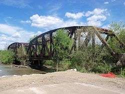 Columbus and Ohio River Railroad bridge over Tuscarawas River next to U.S. Route 36 leads into Gnadenhutten, Ohio | |
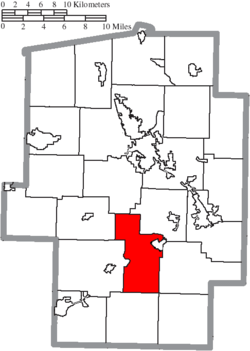 Location of Clay Township in Tuscarawas County | |
| Coordinates: 40°21′23″N 81°27′9″W | |
| Country | United States |
| State | Ohio |
| County | Tuscarawas |
| Area | |
| • Total | 24.7 sq mi (63.9 km2) |
| • Land | 24.2 sq mi (62.6 km2) |
| • Water | 0.5 sq mi (1.3 km2) |
| Elevation | 814 ft (248 m) |
| Population (2000) | |
| • Total | 1,981 |
| • Density | 82.0/sq mi (31.6/km2) |
| Time zone | UTC-5 (Eastern (EST)) |
| • Summer (DST) | UTC-4 (EDT) |
| FIPS code | 39-15574[2] |
| GNIS feature ID | 1087052[1] |
Geography
Located in the southern part of the county, it borders the following townships:
- York Township - north
- Warwick Township - northeast
- Rush Township - east
- Perry Township - southeast corner
- Washington Township - south
- Salem Township - southwest
- Jefferson Township - northwest
Part of the village of Gnadenhutten is located in eastern Clay Township.
Clay Township contains the unincorporated locale of Lock Seventeen.,[4] named for its location at the seventeenth lock of the Ohio Canal.[5]
Name and history
It is one of nine Clay Townships statewide.[6]
Government
The township is governed by a three-member board of trustees, who are elected in November of odd-numbered years to a four-year term beginning on the following January 1. Two are elected in the year after the presidential election and one is elected in the year before it. There is also an elected township fiscal officer, who serves a four-year term beginning on April 1 of the year after the election, which is held in November of the year before the presidential election. Vacancies in the fiscal officership or on the board of trustees are filled by the remaining trustees. The current trustees are Ruby Kinsey, Harvey Morrison, and Tom Morrison, and the fiscal officer is Sharon Miller.[7]
References
- "US Board on Geographic Names". United States Geological Survey. 2007-10-25. Retrieved 2008-01-31.
- "U.S. Census website". United States Census Bureau. Retrieved 2008-01-31.
- Tuscarawas County, Ohio — Population by Places Estimates Ohio State University, 2007. Accessed 15 May 2007.
- "Lock Seventeen". Geographic Names Information System. United States Geological Survey.
- Peacefull, Leonard (1996). A Geography of Ohio. Kent State University Press. p. 217. Retrieved 8 December 2013.
- "Detailed map of Ohio" (PDF). United States Census Bureau. 2000. Retrieved 2007-02-16.
- Tuscarawas County, Ohio — Engineer: Joseph S. Bachman Archived 2007-05-28 at the Wayback Machine. Tuscarawas County. Accessed 2007-06-01.
External links
Municipalities and communities of Tuscarawas County, Ohio, United States | ||
|---|---|---|
| Cities | 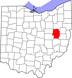 Map of Ohio highlighting Tuscarawas County | |
| Villages | ||
| Townships | ||
| CDPs | ||
| Unincorporated communities | ||
| Ghost town | ||
| Footnotes | ‡This populated place also has portions in an adjacent county or counties | |