Clarmallagh
Clarmallagh (Irish: Clár Maí Locha) is a barony in County Laois (formerly called Queen's County or County Leix), Republic of Ireland.[1][2]
Clarmallagh Clár Maí Locha (Irish) | |
|---|---|
 River Erkina near Durrow | |
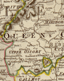
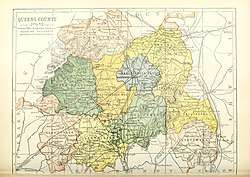 Barony map of Queen's County, 1900; Clarmallagh is yellow, in the south. | |
| Sovereign state | Republic of Ireland |
| Province | Leinster |
| County | Laois |
| Area | |
| • Total | 176.17 km2 (68.02 sq mi) |
Etymology
Clarmallagh means "Flat land of Maigh Locha [lake plain]", referring to Grantstown Lake.[3]
Geography
Clarmallagh is located in south County Laois, to the south of the River Gully, and to the north of the County Kilkenny border. It contains the lower part of the Erkina River where it drains into the River Nore.
History
Clarmallagh barony was anciently the northernmost part of the Kingdom of Osraige (Ossory).
In the early 12th century, Finn Ua Caellaide ruled Magh Locha (Clarmallagh) separately from the rest of Ossory.
It was ruled by the Ó Faoláin (Phelan).[4]
It is referred to in the topographical poem Tuilleadh feasa ar Éirinn óigh (Giolla na Naomh Ó hUidhrín, d. 1420):
I Muiġ Laċa na learg te
Ó Faoláin, fearḋa an fíne
Mór an dúthaiġ as díol dáiḃ
Do lín futha Ó Faoláin
("In Magh Lacha of the warm hill slopes is Ó Faolain of manly tribe; Extensive is the district due to them, which the Ó Faolains have filled.")[5]
Clarmallagh was formerly a part of the Upper Ossory barony, established by 1657; in 1842 it was divided into three cantreds: Upper Woods, Clandonagh and Clarmallagh.
List of settlements
Below is a list of settlements in Clarmallagh barony:
References
- "The Parliamentary Gazetteer of Ireland: Adapted to the New Poor-law, Franchise, Municipal and Ecclesiastical Arrangements, and Compiled with a Special Reference to the Lines of Railroad and Canal Communication, as Existing in 1814-45". A. Fullarton and Company. 8 July 2018 – via Google Books.
- Coote, Sir Charles (8 July 2018). "General View of the Agriculture and Manufactures of the Queen's County: With Observations on the Means of Their Improvement, Drawn Up in the Year 1801 : for the Consideration, and Under the Direction of the Dublin Society". Graisberry & Campbell – via Google Books.
- Carrigan, William (8 July 1981). "The History and Antiquities of the Diocese of Ossory". Рипол Классик – via Google Books.
- Woulfe, Patrick. "Ó Faoláin - Irish Names and Surnames". www.libraryireland.com.
- "The Topographical Poems of John O'Dubhagain and Giolla-na-naomh O'Huidhrin: Edited in the original Irish from MSS. in the Library of the Royal Irish Academy, Dublin, with translation, notes, and introductory dissertations, by John O'Donovan". A. Thom. 8 July 1862 – via Google Books.
- "The statutory rules and orders revised". 8 July 2018 – via Google Books.
Places in County Laois | ||
|---|---|---|
| Towns | 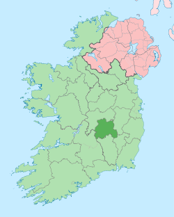 | |
| Villages and Townlands |
| |
| Landforms | ||
| ||