Chualar, California
Chualar is a census-designated place (CDP) in the Salinas Valley of Monterey County, California. Chualar is located 10 miles (16 km) southeast of Salinas,[5] at an elevation of 115 feet (35 m).[4] The population was 1,190 at the 2010 census, down from 1,444 at the 2000 census.
Chualar | |
|---|---|
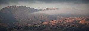 Diablo Mountain View from Chualar | |
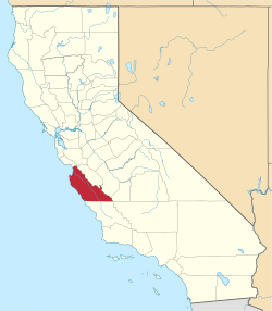
 Location in Monterey County and the state of California | |
 Chualar Location in the United States | |
| Coordinates: 36°34′14″N 121°31′07″W | |
| Country | |
| State | |
| County | Monterey |
| Government | |
| • State Senator | Anna Caballero (D)[1] |
| • Assemblymember | Robert Rivas (D)[1] |
| • U. S. Rep. | Jimmy Panetta (D)[2] |
| Area | |
| • Total | 0.626 sq mi (1.622 km2) |
| • Land | 0.626 sq mi (1.622 km2) |
| • Water | 0 sq mi (0 km2) 0% |
| Elevation | 115 ft (35 m) |
| Population (2010) | |
| • Total | 1,190 |
| • Density | 1,900/sq mi (730/km2) |
| Time zone | UTC-8 (PST) |
| • Summer (DST) | UTC-7 (PDT) |
| ZIP code | 93925 |
| Area code(s) | 831 |
| FIPS code | 06-13364 |
| GNIS feature IDs | 1655896, 2407612 |
Geography
Chualar is located at 36°34′14″N 121°31′07″W.[4]
According to the United States Census Bureau, the CDP has a total area of 0.6 square miles (1.6 km2), all of it land.
In her Spanish and Indian Place Names of California (1914), Sanchez states that Chualar was the indigenous word for an abundant and native goosefoot. This plant could possibly be Chenopodium californicum, the California goosefoot (also known as pigweed). In his 1500 California Place Names (1998), William Bright writes that the name is Spanish for "where the chual grows," chual being Mexican Spanish for pigweed or goosefoot, and derived ultimately from Nahuatl tzoalli.
History
The Chualar post office opened in 1871, closed in 1873, and re-opened in 1874.[5]
At a railroad crossing about one mile south of town, a bus carrying Mexican migrant workers collided with a train in September 1963, killing 32 passengers and injuring 25. It was the most serious road accident in U.S. history, and helped spur the abolition of the bracero guest worker program. The portion of U.S. Route 101 where the accident occurred was named the "Bracero Memorial Highway" on the 50th anniversary of the accident in 2013. At that time two survivors of the crash were still alive.[6][7]
On December 5, 2019, a levee near Chualar was partially breached at 2 pm. Highway 101 was shut down due to the broken levee. Kids were stranded at the local school with a few teachers the night of December 4. The levee break also caused a nursing home to be evacuated.[8]
Demographics
| Historical population | |||
|---|---|---|---|
| Census | Pop. | %± | |
| U.S. Decennial Census[9] | |||
2010
At the 2010 census Chualar had a population of 1,190. The population density was 1,900.5 people per square mile (733.8/km²). The racial makeup of Chualar was 337 (28.3%) White, 1 (0.1%) African American, 2 (0.2%) Native American, 11 (0.9%) Asian, 0 (0.0%) Pacific Islander, 827 (69.5%) from other races, and 12 (1.0%) from two or more races. Hispanic or Latino of any race were 1,151 persons (96.7%).[10]
The whole population lived in households, no one lived in non-institutionalized group quarters and no one was institutionalized.
There were 245 households, 179 (73.1%) had children under the age of 18 living in them, 160 (65.3%) were opposite-sex married couples living together, 49 (20.0%) had a female householder with no husband present, 22 (9.0%) had a male householder with no wife present. There were 17 (6.9%) unmarried opposite-sex partnerships, and 4 (1.6%) same-sex married couples or partnerships. 9 households (3.7%) were one person and 5 (2.0%) had someone living alone who was 65 or older. The average household size was 4.86. There were 231 families (94.3% of households); the average family size was 4.79.
The age distribution was 429 people (36.1%) under the age of 18, 137 people (11.5%) aged 18 to 24, 330 people (27.7%) aged 25 to 44, 235 people (19.7%) aged 45 to 64, and 59 people (5.0%) who were 65 or older. The median age was 26.6 years. For every 100 females, there were 103.1 males. For every 100 females age 18 and over, there were 95.1 males.
There were 251 housing units at an average density of 400.9 per square mile, of the occupied units 112 (45.7%) were owner-occupied and 133 (54.3%) were rented.The homeowner vacancy rate was 0%; the rental vacancy rate was 1.5%. 553 people (46.5% of the population) lived in owner-occupied housing units and 637 people (53.5%) lived in rental housing units.
2000
At the 2000 census there were 1,444 people, 279 households, and 261 families in the CDP. The population density was 2,392.9 people per square mile (929.2/km²). There were 286 housing units at an average density of 473.9 per square mile (184.0/km²). The racial makeup of the CDP was 15.44% White, 0.42% Black or African American, 0.55% Native American, 3.19% Asian, 76.11% from other races, and 4.29% from two or more races. 93.56% of the population were Hispanic or Latino of any race.[11] Of the 279 households 71.0% had children under the age of 18 living with them, 77.4% were married couples living together, 11.8% had a female householder with no husband present, and 6.1% were non-families. 3.9% of households were one person and 1.8% were one person aged 65 or older. The average household size was 5.18 and the average family size was 5.22.
The age distribution was 39.4% under the age of 18, 14.9% from 18 to 24, 30.2% from 25 to 44, 12.0% from 45 to 64, and 3.5% 65 or older. The median age was 23 years. For every 100 females, there were 115.5 males. For every 100 females age 18 and over, there were 115.5 males.
The median household income was $43,125 and the median family income was $40,000. Males had a median income of $20,667 versus $19,643 for females. The per capita income for the CDP was $10,096. About 12.4% of families and 15.0% of the population were below the poverty line, including 18.9% of those under age 18 and 8.5% of those age 65 or over.
References
- "Statewide Database". UC Regents. Archived from the original on February 1, 2015. Retrieved December 30, 2014.
- "California's 20th Congressional District - Representatives & District Map". Civic Impulse, LLC. Retrieved September 24, 2014.
- "2010 Census U.S. Gazetteer Files – Places – California". United States Census Bureau.
- U.S. Geological Survey Geographic Names Information System: Chualar, California
- Durham, David L. (1998). California's Geographic Names: A Gazetteer of Historic and Modern Names of the State. Clovis, Calif.: Word Dancer Press. p. 885. ISBN 1-884995-14-4.
- Newman, Bruce (September 16, 2013). "Bracero Memorial Highway dedicated to celebrate contributions of Mexican field workers and railroad builders". San Jose Mercury News. Retrieved March 6, 2014.
- Flores, Lisa A. (Summer 2013). "A Town Full of Dead Mexicans: The Salinas Valley Bracero Tragedy of 1963, the End of the Bracero Program, and the Evolution of California's Chicano Movement". The Western Historical Quarterly. 44 (2): 124–143. doi:10.2307/westhistquar.44.2.0124.
- Brackett, Ron. "Levee Break Shuts Down California Highway, Strands Students Overnight at School". Weather.com. NOAA. Retrieved 5 December 2019.
- "Census of Population and Housing". Census.gov. Retrieved June 4, 2016.
- "2010 Census Interactive Population Search: CA - Chualar CDP". U.S. Census Bureau. Archived from the original on July 15, 2014. Retrieved July 12, 2014.
- "U.S. Census website". United States Census Bureau. Retrieved 2008-01-31.