Chimalhuacán
Chimalhuacán (Spanish pronunciation: [tʃimalwaˈkan] (![]()
Chimalhuacán | |
|---|---|
City & Municipality | |
 | |
Chimalhuacán | |
| Coordinates: 19°26′15″N 98°57′15″W | |
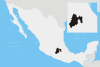
| Country | |
| State | |
| Region | Chimalhuacán |
| Metro area | Greater Mexico City |
| Founded | 1259[1] |
| Municipal Status | October, 1842[1][2] |
| Municipal Seat | Chimalhuacán |
| Government | |
| • Type | Ayuntamiento |
| • Municipal President | Sergio Díaz Espinoza |
| Area | |
| • Municipality | 44.69 km2 (17.25 sq mi) |
| • Water | 0.80 km2 (0.31 sq mi) |
| Elevation (of seat) | 2,240 m (7,350 ft) |
| Population (2010) | |
| • Municipality | 614,453 |
| Time zone | UTC-6 (Central (US Central)) |
| • Summer (DST) | UTC−5 (Central) |
| Postal code (of seat) | 56330 |
| Area code(s) | 55 |
| Demonym | Chimalhuacano (a) |
| Website | Official website (in Spanish) |
The city
The city is practically coextensive with the municipality. The census of 2005 reported a population of 524,223 for the city and 525,389 for the municipality as a whole.[3]
Chimalhuacán was founded 1259 by three chiefs or tlatoani named Huauxomatl, Chalchiutlatonac and Tlatzcantecuhtli. These chiefs and their people originated from Tula and Culhuacán. They spoke Chichimeca and Mexica languages but with time their customs merged and Náhuatl became the dominant language. It became subject to Texcoco, and through that belonged to the Aztec Triple Alliance in 1431. The Spanish town of Chimalhuacán was founded in 1529 and the Dominicans built a church and monastery here in 1563.[3]
The municipality
Although the city takes up almost all of the municipality, Chimalhuacán, as the municipal seat, has governing jurisdiction over the following communities: Colonia Nueva de Guadalupe la Palma, La Pista de los Corredores, Pista Aérea, Tlatel San Juan Xochiaca Parte Alta, and Zapotla.
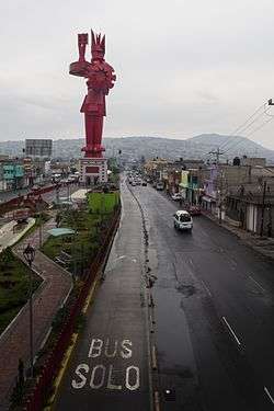
Chimalhuacan have a new park in the center of the municipality, Plaza Estado de Mexico Chimalhuacan, with a library, theater and other places for enterteiment. The entry of municipality has a monument to Chimalhucan, called Guerrero Chimalli, a 62 meter tall copper statue.
The municipality has an area of 46.61 km² (17.996 sq mi). The adjacent municipalities are Nezahualcóyotl, Atenco, Texcoco, Chicoloapan, and La Paz. The city is the sixth largest in the state in population (after Ecatepec de Morelos, Nezahualcóyotl, Naucalpan de Juárez, Toluca, and Tlalnepantla de Baz).[3]
"La Degolladora"
During September 2015, a series of attacks on the citizens of Chimalhuacan began. The attacker was nicknamed "La Degolladora" ("The Decapitator") by local and international press due to the use of knives to injure and kill people randomly.[4]
References
- "Enciclopedia de los Municipios y Delegaciones de México". Instituto Nacional para el Federalismo y el Desarrollo Municipal. Retrieved August 25, 2015.
- "Bando Municipal de Chimalhuacán 2015" (PDF). H. Ayuntamiento de Chimalhuacán 2013-2015. Retrieved August 26, 2015.
- "Enciclopedia de los Municipios de Mexico Estado de Mexico Chimalhuacán". Archived from the original on 2007-09-30. Retrieved 2008-03-07.
- "Víctimas narran modus operandi de la". Publimetro México.
External links
- Chimalhuacan, Mexico
- Municipio de Chimalhuacán Official website