Chersky Range
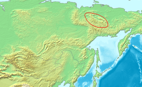
The Chersky Range (Russian: Хребет Черского, Yakut: Черскэй хайалара) is a chain of mountains in northeastern Siberia between the Yana River and the Indigirka River. Administratively the area of the range belongs to the Sakha Republic and Magadan Oblast. The highest peak in the range is 3,003 metres (9,852 ft) tall Peak Pobeda, part of the Ulakhan-Chistay Range. The range lies on the boundary between the Eurasian and North American tectonic plates.[1] The Chersky mountains, along with the neighboring Verkhoyansk Range, have a moderating effect on the climate of Siberia. The ridges obstruct west-moving air flows, decreasing the amount of snowfall in the plains to the west.
| Chersky Range | |
|---|---|
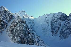 View of Pobeda (Victory) Peak, highest point of the range. | |
| Highest point | |
| Peak | Pobeda |
| Elevation | 3,003 metres (9,852 ft) |
| Coordinates | 64°44′N 142°58′E |
| Dimensions | |
| Length | 1,500 km (930 mi) NW/SE |
| Width | 400 km (250 mi) NE/SW |
| Geography | |
 | |
| Country | |
| Republic / Oblast | Sakha and Magadan |
| Parent range | East Siberian System |
| Geology | |
| Age of rock | Precambrian, Permian, Triassic and Jurassic |
| Type of rock | Schist, sandstone, siltstone and Granite intrusive rocks |
The Moma Natural Park is a protected area located in the southern zone of the range.[2]
History
At some time between 1633 and 1642 Poznik Ivanov ascended a tributary of the lower Lena, crossed the Verkhoyansk Range to the upper Yana and then crossed the Chersky Range to the Indigirka.[3] The range was sighted in 1926 by Sergei Obruchev (Vladimir Obruchev's son) and named by the Russian Geographical Society after the Polish explorer and geographer Ivan Chersky (or Jan Czerski).[4]
Geography
.jpg)

The geographic boundaries of the mountain system are the Yana—Oymyakon Highlands in the southwest and the Momo-Selennyakh Depression in the northeast.[5] The range also includes Ynnakh Mountain (Mat'-Gora), an important mountain in Yakut culture.
Subranges
The system of the Chersky Range comprises a number of subranges running generally from northwest to southeast, including the following:
Between the Yana and Indigirka rivers:
- Khadaranya Range, highest point 2,185 metres (7,169 ft)
- Kisilyakh Range, highest point 1,548 metres (5,079 ft), by river Adycha
- Tas-Khayakhtakh Range, highest point 2,356 metres (7,730 ft)
- Kurundya Range, highest point 1,919 metres (6,296 ft)
- Chelmagin Range, highest point 2,547 metres (8,356 ft)
- Dogdo Range, highest point 2,272 metres (7,454 ft)
- Silyap Range, highest point 2,703 metres (8,868 ft)
- Yana-Oymyakon Highlands
- Elgin Plateau (Эльгинское плоскогорье), highest point 1,590 metres (5,220 ft)
- Oymyakon Plateau, highest point 1,400 metres (4,600 ft)
- Yana Plateau, highest point 1,770 metres (5,810 ft)
Between the Adycha and Sartang rivers:
- Tirekhtyakh Range
- Nelgesin Range
In the upper Kolyma river basin:
- Ulakhan-Chistay Range, highest point 3,003 metres (9,852 ft), near the southern end
- Cherge Range, highest point 2,332 metres (7,651 ft)
- Angachak Range, highest point 2,293 metres (7,523 ft)
- Arga-Tas, highest point 2,400 metres (7,900 ft)
Between the Chibagalakh and Adycha rivers
- Chibagalakh Range, highest point 2,449 metres (8,035 ft)
- Borong Range, highest point 2,681 metres (8,796 ft) (between the Charky and the Adycha)
Between the Indigirka and the Nera rivers:
- Tas-Kystabyt, highest point 2,341 metres (7,680 ft)
- Khalkansky Range, highest point 1,615 metres (5,299 ft), a southern prolongation of Tas-Kystabyt
Northeastern outliers
In some works, a few roughly parallel ranges located off the main system to the northeast, such as the Kyun-Tas Range (highest point 1,242 metres (4,075 ft)), the Selennyakh Range (highest point highest point Saltag-Tas (2,021 metres (6,631 ft)), and the adjacent Moma Range (highest point 2,533 metres (8,310 ft)) with the Moma-Selennyakh Depession running along their western side, are included in the Chersky mountain system.[6]
Other ranges of the system are the Irgichin Range, Porozhny Range, Inyalin Range, Volchan Range, Silen Range, Onel Range, and Nendelgin Range, among others.[7]
Tectonics
The precise nature of the boundary between the North American and Eurasian tectonic plates in the area of the Chersky Range is still not fully understood and is the subject of ongoing research. By the 1980s, the Chersky Range was considered mostly a zone of continental rifting where the crust was spreading apart.[8] However, the current view is that the Chersky Range is mostly an active suture zone, a continental convergent plate boundary, where compression is occurring as the two plates press against each other.[9] There is thought to be a point in the Chersky Range where the extensional forces coming from the north change to the compressional forces noted throughout most of the range. The Chersky Range is also thought to include a geologic triple junction where the Ulakhan Fault intersects the suture zone. Whatever the exact nature of the regional tectonics, the Chersky Range is a seismically active zone. It connects in the north with the landward extension of the Laptev Sea Rift, itself a continental extension of the Mid-Arctic Gakkel Ridge.
See also
Notes
- News Archive - The Earth Institute at Columbia University
- Moma Natural Park Official site
- G. Patrick March,'Eastern Destiny:Russia in Asia and the North Pacific, 1996, chapter 3
- Obruchev, S. (1927). "Discovery of a Great Range in North-East Siberia". The Geographical Journal. 70 (5): 464–470. doi:10.2307/1783479. JSTOR 1783479.CS1 maint: ref=harv (link)
- Хребет Черского (in Russian)
- Chersky Range // Great Russian Encyclopedia : [in 35 vols.] / Ch. ed. Yu.S. Osipov . - M , 2004—2017.
- Oleg Leonidovič Kryžanovskij, A Checklist of the Ground-beetles of Russia and Adjacent Lands. p. 15
- "Geodynamics and Late Cenozoic Evolution of the Asia/Pacific Transitional Zone", in Tectonics, International Geological Congress Staff, 27th International Geological Congress, Published 1984 by VSP
- The Physical Geography of Northern Eurasia, ed. Maria Shahgedanova, published by Oxford University Press 2003
External links

- Oymyakon Ring Structure in the North-Eastern Siberia