Cheoah River
The Cheoah River is a tributary of the Little Tennessee River in North Carolina in the United States.
| Cheoah River Tributary to Little Tennessee River | |
|---|---|
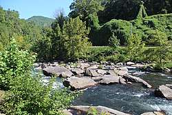 Cheoah River in Tapoco, North Carolina | |
| Location | |
| Country | United States |
| State | North Carolina |
| County | Graham Swain |
| Physical characteristics | |
| Source | Confluence of Sweetwater and Tulula Creeks |
| ⁃ location | Robbinsville, North Carolina |
| ⁃ coordinates | 35°19′38.3196″N 83°48′7.635″W |
| ⁃ elevation | 1,993 ft (607 m)[1] |
| Mouth | |
⁃ location | Little Tennessee River |
⁃ coordinates | 35°26′55.307″N 83°56′22.65″W |
⁃ elevation | 1,106 ft (337 m)[1] |
| Length | 18.16 mi (29.23 km)[2] |
| Basin size | 215.14 square miles (557.2 km2)[3] |
| Discharge | |
| ⁃ location | Little Tennessee River |
| ⁃ average | 687.43 cu ft/s (19.466 m3/s) at mouth with Little Tennessee River[3] |
| Basin features | |
| Progression | northwest |
| River system | Little Tennessee → Tennessee → Ohio → Mississippi |
| Tributaries | |
| ⁃ left | Tulula Creek Long Creek Stillhouse Hollow Massey Branch Snowbird Creek West Buffalo Creek Charikus Branch Farley Cove Santeetlah Creek Gold Mine Branch Rock Creek Laurel Branch Persimmon Tree Branch Falls Branch Deep Creek Frisby Branch Barker Creek Bear Creek Otter Rock Branch Yellowhammer Branch |
| ⁃ right | Sweetwater Creek Mountain Creek Ground Squirrel Branch East Buffalo Creek Gladdens Creek Cochran Creek Cochran Creek Yellow Creek Puncheon Camp Branch Halfmile Branch Meadow Branch |
| Waterbodies | Santeetlah Lake |
It is located in Graham County in far western North Carolina, near Robbinsville, and is approximately 20 miles in length. Its headwaters are in the Appalachian Mountains where it flows northwest near Robbinsville, to the Lake Santeetlah and flows towards the Tennessee border with a terminus at the Little Tennessee between the Cheoah Dam and Lake Calderwood.
Variant names
According to the Geographic Names Information System, it has also been known historically as:[4]
- Cheowa River
- Cheowah River
References
- "Cheoah River Topo Map, Graham County NC (Tapoco Area)". TopoZone. Locality, LLC. Retrieved 16 October 2019.
- "ArcGIS Web Application". epa.maps.arcgis.com. US EPA. Retrieved 16 October 2019.
- "Cheoah River Watershed Report". Waters Geoviewer. US EPA. Retrieved 16 October 2019.
- "GNIS Detail - Cheoah River". geonames.usgs.gov. US Geological Survey. Retrieved 16 October 2019.
| Wikimedia Commons has media related to Cheoah River. |
- "Cheoah River". Geographic Names Information System. United States Geological Survey. Retrieved 2011-01-03.
This article is issued from Wikipedia. The text is licensed under Creative Commons - Attribution - Sharealike. Additional terms may apply for the media files.