Charnwood (ward)
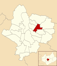
Charnwood was an electoral ward and administrative division of the city of Leicester, England. The population of the ward at the 2011 census was 13,291.[1] It comprised the northern Leicester suburb of Northfields and its Tailby and Morton ex-council estates.
| Charnwood | |
|---|---|
 | |
| Population | 13,291 (2011) |
| Unitary authority | |
| Ceremonial county | |
| Region | |
| Country | England |
| Sovereign state | United Kingdom |
| Post town | LEICESTER |
| Postcode district | LE5 |
| Dialling code | 0116 |
| Police | Leicestershire |
| Fire | Leicestershire |
| Ambulance | East Midlands |
| UK Parliament | |
Charnwood was bounded by the wards of Belgrave to the north-west, Rushey Mead to the north, Humberstone & Hamilton to the east, Coleman to the south, Spinney Hills to the south-west and Latimer to the west.[2] To the west, the Midland Main Line separated it from Belgrave, and to the south the Uppingham Road separates it from Spinney Hills and North Evington. To the east it bordered Humberstone, and to the north borders the Troon Way industrial estate.
Northfields was named for one of three open fields that once nearly surrounded Leicester. The field was enclosed in 1764 and then used as residential building land 'in good time for the population increase' of the industrial revolution, meaning that Leicester was largely spared the overcrowding problems typical of industrialising towns of that time.[3]
Northfields has had a bad reputation for criminal activities. Despite being only 3 small estates it was responsible for 30% of the crime rate within the Leicester area. In response The Northfields Project was set upin order to help to combat crime and make Northfields a safer place to live. The scheme improved areas such as security fencing, lighting and public recreational spaces.
The Charnwood ward, which was represented on Leicester City Council and covered the area, was abolished in 2015 with most of the area now being part of the Troon ward.
References
- "City of Leicester Ward population 2011". Neighbourhood Statistics. Office for National Statistics. Retrieved 4 June 2016.
- Leicester City Council. "Ward Maps". Archived from the original on 13 June 2011. Retrieved 11 October 2011.
- Hoskins, W.G., 'The Making of the English Landscape' (1955)
The Northfields Project Report