Belgrave, Leicester
Belgrave is an area, suburb, electoral ward, and administrative division of the city of Leicester, England.
| Belgrave | |
|---|---|
 | |
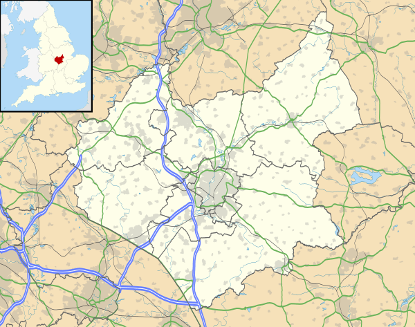 Belgrave Location within Leicestershire | |
| Population | 11,558 |
| Unitary authority | |
| Ceremonial county | |
| Region | |
| Country | England |
| Sovereign state | United Kingdom |
| Post town | LEICESTER |
| Postcode district | LE4 |
| Dialling code | 0116 |
| Police | Leicestershire |
| Fire | Leicestershire |
| Ambulance | East Midlands |
| UK Parliament | |
The old Belgrave Village, containing the Belgrave Conservation Area, including Belgrave Hall, the 12th-century St Peter's Church and The Talbot pub, is to the west of Loughborough Road.
Geography
Belgrave is bounded by the suburb of Rushey Mead to the north, Spinney Hill and North Evington to the south-east, St Matthew's to the south, and the Abbey Ward to the west.[1] It is located north of the centre of Leicester, in the eastern part of the city. The old village part of Belgrave is close to the county border, which is located on the other side of the Red Hill Roundabout.
Etymology
The settlement was named in the Domesday Book as Merdegrave (from Old English mearð 'marten' + grāf 'grove'). However, after the Norman Conquest the merde, which means excrement in French, was changed to bel.[2]
History
One of the earliest mentions of this place is in the Domesday book where it is listed amongst the lands given to Hugh de Grandmesnil[3] by the King. The land consisted of a mill, 24 acres (97,000 m2) of meadow and land for 6 ploughs.
The name was used for the large 19th-century terraced developments along the A607 (Belgrave Road and then Melton Road). This area now has a large, vibrant Asian community featuring the "Golden Mile", a stretch of road a mile long named that due to its particularly high concentration of jewellery shops.[4] The Asian community based in and around Belgrave and Melton Road have been residents since the early 1970s.
The Belgrave Hall area is a conservation area.[5]
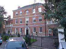
Belgrave is home to Belgrave Hall & Gardens. Belgrave Hall (1709) is a Grade II* listed building in a plain classical style. The Hall is in the midst of two acres of serene walled gardens that are open to the public during special events. It has changed hands many times but the owners have always played a major role in the economic, social and charitable life of the community.
St Peter's Church is the oldest building in the local conservation area, parts of which date from the twelfth century. Archaeologists believe there may be an earlier Saxon church beneath the present structure.
The Talbot Inn has origins in the 14th century, when it was a popular stop providing bed and board to those who travelled through Leicester along Loughborough Road.
Mountsorrel he mounted at,
Rodely he rode by,
Onelep he leaped o'er,
At Birstall he burst his gall,
At Belgrave he was buried at.
Demographics
According to the 2001 UK Census, 104 Pacific Island born people were residing in Belgrave, with many more being of Pacific Islander descent. This is the largest number for any location in the UK.[7]
The area, since the 1970s, has had a large Asian population and is now predominately Asian.
In the 2011 census the population of Belgrave was 11,558 and is made up of approximately 51% females and 49% males. The average age of people in Belgrave is 36, while the median age is lower at 34. 43.0% of people living in Belgrave were born in England. Other top answers for country of birth were 28.4% India, 5.6% Kenya, 3.2% Sri Lanka, 1.6% Africa not otherwise specified, 0.8% Pakistan, 0.6% Zimbabwe, 0.4% Somalia, 0.3% Bangladesh, 0.2% Scotland.
46.7% of people living in Belgrave speak English as their main language. The other top languages spoken are 35.8% Gujarati, 4.3% Panjabi, 3.3% Tamil, 1.3% Portuguese, 0.9% South Asian Language, 0.9% Polish, 0.9% Hindi, 0.9% Urdu, 0.6% Somali.
The religious make up of Belgrave is 54.6% Hindu, 14.3% Christian, 14.1% Muslim, 6.4% No religion, 5.5% Sikh, 0.3% Buddhist.
443 people did not state a religion. Four people identified as Jedi knights.
48.1% of people are married, 4.0% cohabit with a member of the opposite sex, 0.5% live with a partner of the same sex, 28.9% are single and have never married or been in a registered same sex partnership, 7.5% are separated or divorced. There are 487 widowed people living in Belgrave.
The top occupations listed by people in Belgrave are Elementary at 20.6%, Process, plant and machine operatives at 18.7%, Elementary administration and service at 14.3%, Sales and customer service at 13.1%, Sales at 10.7%, Sales Assistants and Retail Cashiers at 9.8%, Administrative and secretarial at 9.6%, Caring, leisure and other service at 9.2% and Process Operatives at 8.5%.
Education
Schools in the area
Primary schools: Belgrave St Peter's Church of England Primary, Mellor Community Primary, Catherine Infants and Catherine Juniors, St Patrick's Catholic Primary, Abbey Primary. Rushey Mead Primary and Wyvern Primary are both located near to Belgrave in the neighbouring area of Rushey Mead and are attended by many schoolchildren from Belgrave.
Places of interest
- Belgrave Hall - An 18th-century hall owned at one point by the locally prominent Ellis family. It was a museum but is now an events venue and is occasionally used for public events with the gardens opening periodically throughout the year.[8]
- The Belgrave Conservation Area - Includes a church dating back to the twelfth century and The Talbot pub.
- Golden Mile - Named that due to the many Indian shops along it, including gold jewellery, food and saree shops. This road is at the centre of annual Diwali celebrations in the city, having rows of lights that are switched on in front of thousands of visitors each year.[9]
Scenery
The River Soar runs along the west of Belgrave.
Transport
Bus
The Number 22 First bus travels to and from Evington via Leicester City Centre and then on to Belgrave on the A607 Belgrave and Melton Roads and then Marfitt Street, Gipsy Lane and Barkby Road before proceeding into Rushey Mead on Wyvern Avenue and Gleneagles Avenue and then turning around on Trevino Drive, just before the Leicestershire county boundary and the village of Thurmaston.
The Number 21 First service travels from Leicester City Centre and through the St Matthew's estate before getting on to Catherine Street and then passing through Rushey Mead and then on to Charnwood before eventually reaching its terminus in the nearby county village of Thurmaston.
Arriva services 5, 5A and 6 travelling to and from Thurmaston, East Goscote and Melton Mowbray in Leicestershire travel through Belgrave on the A607 Belgrave and Melton Roads.
The Arriva service 127 to and from Shepshed via Loughborough travels down Loughborough Road and then on to Belgrave Road at Melton Turn before proceeding into Leicester City Centre.
The nearest bus stations, both in Leicester City Centre are The Haymarket Bus Station, where buses to or from Belgrave start and terminate at and St Margaret's Bus Station, which is mostly used for trips.
Train
The nearest Train Station is Leicester Railway Station, in Leicester City Centre, 2.2 miles away from Belgrave.
Airport
The nearest airport is East Midlands Airport, in Leicestershire and 19.2 miles away from Belgrave.
Politics
Belgrave is located within the Leicester East parliamentary constituency, a safe Labour seat, currently represented by Labour MP Keith Vaz.
Belgrave is represented within the East Midlands parliamentary constituency in the European Parliament.
Former Councillors for Belgrave include Archibald Berridge and Ramnik Kavia, both of whom served as Lord Mayors of Leicester, Colin Hall, the city's Lord Mayor from 2010–11 and a resident of the area since 1968 and Manjula Sood, Britain's first Asian woman Lord Mayor.
The Belgrave ward is currently represented on Leicester City Council by Labour Councillors Padmini Chamund, Nita Solanki and Mahendra Mohanbhai Valand.
Council Election Results
Belgrave 2019
| Party | Candidate | Votes | % | ± | |
|---|---|---|---|---|---|
| Labour | Padmini Chamund | 5872 | |||
| Labour | Nita Solanki | 5383 | |||
| Labour | Mahendra Mohanbhai Valand | 4707 | |||
| Conservative | Ramesh Pamsi Bhulabhai | 1205 | |||
| Conservative | Devi Prakashveer Singh | 951 | |||
| Conservative | Jagtar Singh | 842 | |||
| Green | Mags Lewis | 497 | |||
| Independent | Sanjay Prem Gogia | 324 | |||
| Liberal Democrats | Asit Sodha | 293 | |||
| Independent | Khandubhai Vanmalibhai Patel | 211 | |||
| Majority | |||||
| Turnout | |||||
Belgrave 2015
| Party | Candidate | Votes | % | ± | |
|---|---|---|---|---|---|
| Labour | Mansukhlal Dharamshi Chohan | 5,705 | |||
| Labour | Manjula Sood | 5,593 | |||
| Labour | John William Thomas | 4,653 | |||
| Conservative | Assoc Faquir | 1509 | |||
| Conservative | Sathish Maroju | 1485 | |||
| Conservative | Manish Naresh Teli | 1273 | |||
| Green | Dinah Gilian Freer | 466 | |||
| UKIP | Darren Millward | 318 | |||
| UKIP | Donna Millward | 270 | |||
| UKIP | Scott Prendergast | 263 | |||
| LICC | Alexander Morgan | 199 | |||
| Majority | |||||
| Turnout | 21734 | 67.7 | |||
| Labour hold | Swing | ||||
Notable people
- John Ellis - Quaker, noted liberal reformer, businessman, Chairman of Midland Railway, MP for Leicester and a former owner and resident, along with his family of Belgrave Hall.
- Tony Sibson - Professional boxer and former European and Commonwealth middleweight champion, lived in and went to school in Belgrave.
- Jennie Fletcher - British competitive swimmer, Olympic gold medallist and former world record-holder, born in Belgrave.
- Tom Sidwell - cricketer, born in Belgrave.
- George Walton - cricketer, born and died in Belgrave.
- David Weston - artist and author, born in Belgrave.
References
- Leicester City Council. "Ward Maps". Retrieved 11 October 2011.
- "Dictionary of American Family Names". Google Books. Oxford University Press. 2003. p. 130. Retrieved 1 December 2019.
- Domesday Book: A Complete Transliteration. London: Penguin, 2003. p. 653 ISBN 0-14-143994-7
- "Leicester Belgrave regeneration". BBC News. 9 August 2014. Retrieved 6 March 2019.
- "The Belgrave Hall Conservation Area". Leicester City Council. Retrieved 6 March 2019.
- Northall, G.F. (2004). English Folk Rhymes 1892. Kessinger Publishing. p. 576. ISBN 9781417978045. Retrieved 13 March 2009.
- "Pacific Islanders in Belgrave". BBC News. Retrieved 6 March 2019.
- "Belgrave Hall". www.leicester.gov.uk. Retrieved 7 December 2018.
- "Flyover regeneration work begins". BBC News. 9 August 2014. Retrieved 7 December 2018.
- "Belgrave statement of persons nominated" (PDF). Leicester City Council. Retrieved 17 April 2019.