Central Province, Zambia
Central Province is one of Zambia's ten provinces. The provincial capital is Kabwe, which is the home of the Mulungushi Rock of Authority. Central Province has an area of 94,394 km (58,654 mi). It borders eight other provinces and has twelve districts. The total area of forest in the province is 9,095,566 ha (22,475,630 acres), and it has a national park and three game management areas.
Central | |
|---|---|
 Kundalila Falls | |
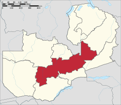 Map of the Central Province | |
| Country | |
| Capital | Kabwe |
| Area | |
| • Total | 110,450 km2 (42,640 sq mi) |
| Elevation | 1,184 m (3,885 ft) |
| Population (2018) | |
| • Total | 1,743,999 |
| • Density | 16/km2 (41/sq mi) |
| Time zone | UTC– |
| HDI (2018) | 0.585[1] medium · 5th |
As of 2010, Central Province had a population of 1,307,111, comprising 10.05% of the total Zambian population. The literacy rate stood at 70.90% against a national average of 70.2%.[2] Bemba was the most spoken language with 31.80% speaking it, and Lala was the majority clan in the province, comprising 20.3% of population. Central Province contains 20.64% of the total area of cultivated land in Zambia and contributes 23.85% of the total agricultural production in the country, with wheat being the major crop.
The Ikubi Lya Loongo festival during July and Ichibwela Mushi festival during September are the major festivals celebrated in the province. Kafue National Park, the country's largest, is shared with Southern and North-Western Provinces, and other natural areas include Blue Lagoon National Park, Kasanka National Park, the Bangweulu Wetlands, South Luangwa National Park, the Lunsemfwa and Lukusashi river valleys and Lukanga Swamp.
History

Central Province is considered the birthplace of the national movement of Zambia. The United National Independence Party (UNIP) was founded in Kabwe by Kenneth Kaunda, who later became the first President of Zambia and remained in office from 1964 to 1991. The provincial capital is Kabwe, home of the Mulungushi Rock of Authority. This is a historic site, an isolated flat-topped hill, where in 1960, UNIP met for the first time, away from the eye of the colonial administration.[3] It is still used for political gatherings, but the open air assemblies have been replaced by a conference centre built nearby at Mulungushi University.[3] The Mulungushi River gives its name to many historical policies, buildings and organizations. The 1968 Mulungushi Declaration proclaimed the country as a socialist nation. Mulungushi Hall in the capital is the venue for most international conventions.[4] The city of Kapiri Mposhi was a historic site during the post-colonial era fight against White minorities.
As of 2013, Chisamba, before a part of Chibombo District, was declared a district on its own by the President, Michael Sata. It is to the "East Of Chibombo" (separating Chibombo from Luano District).[5] As of 2015, Ngabwe, before a part of Kapiri Mposhi District, was declared a district on its own, with a proposal for it to become Zambia's new capital city by former infrastructure minister Lucky Mulusa. It is to the "West Of Kapiri Mposhi" (separating Kapiri Mposhi From the North-Western Province border).[6] [7] In 2012, President Michael Sata proposed for Itezhi-Tezhi District to be moved from Southern Province to Central Province, which eventually happened and in February 2018, President Edgar Lungu moved Shibuyunji District from Lusaka Province to Central Province.[8] Chitambo District was also created by splitting Serenje District (Separating Serenje District from the Muchinga Province border).
Adding Chisamba District, Ngabwe District, Itezhi-Tezhi District, Shibuyunji District, Luano District & Chitambo District to the original districts brings the total to 12 districts.
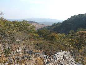
Geography
Central Province has an area of 94,394 km (58,654 mi) and shares a border with eight other provinces. The total area of forest in the province is 9,095,566 ha (22,475,630 acres). The province has a national park and three game management areas. There are six districts in the province. The province has fertile soil conducive for the growth of cotton and maize. Lukanga Swamp has been identified by the International Monetary Fund as a potential place for a fishing industry. Precious metals are found in the Mkushi area, gold in Mumbwa, and coal in Kapiri Mposhi.[9][10] Lukanga Swamp is a permanent swamp covering 1,850 km2 at the mouths and along the Lukanga and Kafue rivers. It contains many lagoons like Lake Chiposhye and Lake Suye.[11] TAZARA, the Tanzania-Zambia railway line, has a major terminal in the city. It provides connectivity to the port in Tanzania from Zambia.[12]
| Climate data for Central (Zambia) | |||||||||||||
|---|---|---|---|---|---|---|---|---|---|---|---|---|---|
| Month | Jan | Feb | Mar | Apr | May | Jun | Jul | Aug | Sep | Oct | Nov | Dec | Year |
| Record high °C (°F) | 27 (81) |
27 (81) |
27 (81) |
26.5 (79.7) |
25.2 (77.4) |
23.7 (74.7) |
23.5 (74.3) |
26.1 (79.0) |
29.8 (85.6) |
31.3 (88.3) |
29.8 (85.6) |
27.3 (81.1) |
31.3 (88.3) |
| Average high °C (°F) | 21.1 (70.0) |
21 (70) |
20.7 (69.3) |
20 (68) |
17.8 (64.0) |
15.9 (60.6) |
15.9 (60.6) |
18.4 (65.1) |
22.1 (71.8) |
24.1 (75.4) |
23 (73) |
21.3 (70.3) |
24.1 (75.4) |
| Average low °C (°F) | 17.3 (63.1) |
17.4 (63.3) |
16.5 (61.7) |
14.4 (57.9) |
11.4 (52.5) |
13.1 (55.6) |
8.7 (47.7) |
10.9 (51.6) |
14.5 (58.1) |
17.1 (62.8) |
17.6 (63.7) |
17.5 (63.5) |
8.7 (47.7) |
| Average precipitation mm (inches) | 20 (0.8) |
16 (0.6) |
11 (0.4) |
3 (0.1) |
0 (0) |
0 (0) |
0 (0) |
0 (0) |
0 (0) |
2 (0.1) |
10 (0.4) |
19 (0.7) |
81 (3.2) |
| Source: [13] | |||||||||||||
Demographics
| Historical population | ||
|---|---|---|
| Year | Pop. | ±% |
| 1964 | 505,000 | — |
| 1969 | 713,000 | +41.2% |
| 1980 | 942,589 | +32.2% |
| 1990 | 983,914 | +4.4% |
| 2000 | 1,012,257 | +2.9% |
| 2010 | 1,307,111 | +29.1% |
| Sources: | ||
According to the 2010 Zambian census, Central Province had a population of 1,307,111, comprising 10.05% of the total Zambian population of 13,092,666. There were 648,465 males and 658,646 females, making the sex ratio 1,016 females for every 1,000 males, compared to the national average of 1,028.[16] The literacy rate stood at 70.90% against a national average of 70.2%.[2] Approximately 74.87% of people lived in rural areas, while 25.13% lived in urban areas. The total area of the province is 94,394 km2 and the population density was 13.80 per km2.[17] The decadal population growth of the province was 2.60%. The median age in the province at the time of marriage was 20.6.[18] The average household size was 5.5, with the average size of families headed by women being 4.8 and 5.8 for families headed by men.[19] In the province, 54.30% were eligible to vote.[20] The unemployment rate was 12.70%. The total fertility rate was 6.3, the complete birth rate was 6.1, the crude birth rate was 36.0, the child–woman ratio at birth was 785, the general fertility rate was 156, the gross reproduction rate was 2.5, and the net reproduction rate was 1.8.[21] The labour force constituted 52.20% of the total population. Out of the labour force, 62.7% were men and 42.2% were women. The annual growth rate of the labour force was 2.2%.[22] Bemba was the most spoken language with 31.80% speaking it.[23] The total population in the province with albinism stood at 3,007.[24] The life expectancy at birth stood at 52 compared to the national average of 51.[25] Lala was the largest clan in the province, comprising 20.3% of population.[26]
Administration
| Profession[27] | % of working population |
| Agriculture, Forestry, and Commercial Fishing | 13.00 |
| Community, Social, and Personal | 8.20 |
| Construction | 7.20 |
| Electricity, Gas, and Water | 8.20 |
| Finance and Insurance | 3.50 |
| Hotels and Restaurants | 10.20 |
| Manufacturing | 7.20 |
| Mining and Quarrying | 3.90 |
| Transportation and Storage | 4.70 |
| Wholesale and Retail Trade | 9.30 |
The provincial administration is set up purely for administrative purposes. The province is headed by a minister appointed by the President and there are ministries of central government for each province. The administrative head of the province is the Permanent Secretary, appointed by the President. There is a Deputy Permanent Secretary, heads of government departments and civil servants at the provincial level. Central Province is divided into twelve districts: Chibombo District, Chisamba District, Chitambo District, Itezhi-Tezhi District, Kabwe District, Kapiri Mposhi District, Luano District, Mkushi District, Mumbwa District, Ngabwe District, Serenje District and Shibuyunji District[28][29]. All of the district headquarters are the same as the district names. There are six councils in the province, each of which is headed by an elected representative, called a councilor. Each councilor holds office for three years.[30] The administrative staff of the council is selected based on the Local Government Service Commission from within or outside the district. The office of the provincial government is located in each of the district headquarters and has provincial local government officers and auditors. Each council is responsible for raising and collecting local taxes and the budgets of the council are audited and submitted every year after the annual budget. The elected members of the council do not draw salaries, but are paid allowances from the council. Central Province is predominantly rural and hence there are no city or municipal councils. The government stipulates 63 different functions for the councils, with the majority of them being infrastructure management and local administration. Councils are mandated to maintain each of their community centres, zoos, local parks, drainage systems, playgrounds, cemeteries, caravan sites, libraries, museums and art galleries. They also work with specific government departments for helping in agriculture, conservation of natural resources, providing postal service, and establishing and maintaining hospitals, schools and colleges. The councils prepare schemes that encourage community participation.[31]
Economy and society
| HIV infected & AIDS deaths[32] | ||
|---|---|---|
| Year | HIV infected | AIDS deaths |
| 1985 | 1,448 | 28 |
| 1990 | 12,516 | 410 |
| 1995 | 49,682 | 2,306 |
| 2000 | 79,902 | 5,833 |
| 2005 | 87,144 | 8,747 |
| 2010 | 84,321 | 9,016 |
As of 2014, a total of 6,853 (59.2%) out of 11,576 candidates obtained a Full School Certificate (the Grade 12 examination).[33] The unemployment rate was 10% and the youth unemployment rate was 14.2% in 2016.[34] As per the Living Condition Monitoring survey of 2015, malaria was the most common illness and accounted for 14.3% of reported deaths.[35] HIV prevalence in the province as of 2013–14 was 12.5% overall, 14.8% for women, and 9.8% for men.[36]
The total area of crops planted during 2014 in the province was 391,593.23 hectares, which constituted 20.64% of the total area cultivated in Zambia. The net production stood at 971,484 metric tonnes, which formed 23.85% of the total agricultural production in the country. Wheat was the major crop in the province with 99,758 metric tonnes, constituting 49.51% of the national output.[37] The annual rate of inflation in the province as of August 2017 was 7.2% against a national rate of 6.3%, and the provincial contribution to the national inflation during the same period was 0.8.[38]
Culture
The Ikubi Lya Loongo festival is celebrated in Mumbwa district by the Sala tribe during July, the Ichibwela Mushi festival is celebrated in Mkushi district by the Bisa/Swaka/Lala tribe during September, the Musaka Jikubi festival is celebrated in Mumbwa district by the Kaonde tribe during September, the Kulamba Kubwalo festival is celebrated in Chibombo district by the Lenje tribe during October, and the Ikubi Lya Malumbe-Munyama festival is celebrated in Mumbwa district by the Kaonde Ila tribe during October.[39] The Kulamba Kubwalo festival is attended by 250,000 people annually to pay tribute to their leader and celebrate the harvest.[40]
Environment
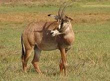
Kafue National Park, the country's largest national park, is shared with the Southern and North-Western Provinces. Blue Lagoon National Park located in the northern part of the Kafue Flats, Kasanka National Park in the border of Bangweulu Wetlands, South Luangwa National Park, the Lunsemfwa and Lukusashi River valleys and Lukanga Swamp are the major wildlife and game areas in the province.[41][9] Kundalila, a waterfall in Serenje district, is a declared national heritage site.[42]
References
- "Sub-national HDI - Area Database - Global Data Lab". hdi.globaldatalab.org. Retrieved 2018-09-13.
- Census 2012, p. 24
- "Steady as a Rock". The Lowdown Magazine. 30 October 2012. Retrieved 14 October 2017.
- Mwakikagile 2010, p. 36
- http://www.lusakavoice.com/2013/06/21/new-chisamba-district-takes-shape/
- https://www.daily-mail.co.zm/ngabwe-fights-to-get-on-the-map/
- http://www.africanews.com/2017/05/25/zambia-plans-to-move-its-capital-from-lusaka-to-ngabwe-in-the-centre//
- Government of Zambia (13 April 2018). "Statutory Instrument No 28 of 2018". Zambia Government Gazette.
- International Monetary Fund 2007, p. 328
- Kachali, Rhoda Nthena. Stakeholder interactions in wetlands: implications for social ecological system sustainability a case of Lukanga Swamps, Zambia (PDF) (Report). Lund University. p. 24. Retrieved 2 September 2017.
- Musambachime, Mwelwa C (2016). One Zambia, One Nation, One Country. Xlibris Corporation. p. 136. ISBN 9781514462287.
- Mwakikagile 2010, p. 59
- "Weather statistics for Central (Zambia)". Norway: Norwegian Meteorological Institute and Norwegian Broadcasting Corporation. 2007. Retrieved 20 October 2016.
- Census of population and housing, 1969 (PDF) (Report). Lusaka: Central Statistical Office, Republic of Zambia. 1970. pp. A6-7. Archived from the original (PDF) on 2015-10-26.
- Summary report for the 2000 Census of population (Report). Lusaka: Central Statistical Office, Republic of Zambia. 2003. p. 6. Archived from the original on 2016-10-14.
- Census 2012, p. 7
- Census 2012, p. 9
- Census 2012, pp. 12–13
- Census 2012, p. 19
- Census 2012, p. 21
- Census 2012, p. 44
- Census 2012, p. 93
- Census 2012, p. 99
- Census 2012, p. 78
- Census 2012, p. 74
- Census 2012, p. 64
- "Labour force survey". Central Statistical Office of Zambia. 2008. Retrieved 17 October 2016.
- "Population and Demography of Zambia". Central Statistical Office of Zambia. 2015. Retrieved 10 September 2017.
- "Central Province | Ministry Of Local Government And Housing." Mlgh.Gov.Zm, 2017, "Archived copy". Archived from the original on 2017-09-10. Retrieved 2017-09-10.CS1 maint: archived copy as title (link).
- Zambia Public administration Country profile (PDF) (Report). Division for Public Administration and Development Management (DPADM), Department of Economic and Social Affairs (DESA), United Nations. 2004. p. 7. Retrieved 16 October 2016.
- The local government system in Zambia (PDF) (Report). Common Wealth Local Government Forum. pp. 218–220. Retrieved 16 October 2016.
- "AIDS and HIV statistics". Central Statistical Office of Zambia. 2011. Retrieved 17 October 2016.
- Central Statistical Office 2016, p. 22
- The Statistician (PDF) (Report). 6. Lusaka: Central Statistical Office, Republic of Zambia. July 2017. p. 4.
- 2015 Living Condition Monitoring survey report (PDF) (Report). 6. Lusaka: Central Statistical Office, Republic of Zambia. November 2016. p. 43.
- Central Statistical Office 2016, p. 35
- "Agriculture statistics of Zambia 2014". Central Statistical Office of Zambia. 2016. Retrieved 17 October 2016.
- "The Monthly" (PDF). 172. Lusaka: Central Statistical Office, Republic of Zambia. August 2017: 5–6. Cite journal requires
|journal=(help) - "Traditional Ceremonies". Ministry of Tourism and Arts, Republic of Zambia. 2011. Archived from the original on 2016-07-01. Retrieved 20 October 2016.
- Taylor, Scott D. (2006). Culture and Customs of Zambia. Greenwood Publishing Group. p. 115. ISBN 9780313332463.
central province zambia.
- "Areas in Zambia". Zambia Tourism Board. 2011. Retrieved 19 October 2016.
- "Kundalila: The unmarketed tourism marvel". Daily Mail. 13 September 2016. Retrieved 21 August 2017.
Sources
- Mwakikagile, Godfrey (2010). Zambia: Life in an African Country. New Africa Press. ISBN 9789987160112.
- Summary report for the 2010 Census of population (PDF) (Report). Lusaka: Central Statistical Office, Republic of Zambia. 2012. Archived from the original (PDF) on 2015-10-26.
- Selected Socio-economic indicators report 2015 (PDF) (Report). 6. Lusaka: Central Statistical Office, Republic of Zambia. 2016.
- Zambia: Poverty Reduction Strategy Paper (Report). International Monetary Fund. 2007.
External links
![]()
| Central Province | |
|---|---|
| Copperbelt Province | |
| Eastern Province | |
| Luapula Province | |
| Lusaka Province | |
| Muchinga Province | |
| Northern Province | |
| North-Western Province | |
| Southern Province | |
| Western Province | |
| Authority control |
|---|