Kabwe
Kabwe is the capital of the Zambian Central Province with a population estimated at 202,914 at the 2010 census.[1] Named Broken Hill until 1966, it was founded when lead and zinc deposits were discovered in 1902. Kabwe also has a claim to being the birthplace of Zambian politics as it was an important political centre during the colonial period.[2] [3]It is an important transportation and mining centre.
Kabwe | |
|---|---|
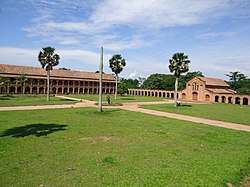 Kabwe Grand Seminary | |
 Kabwe Location in Zambia | |
| Coordinates: 14°26′S 28°27′E | |
| Country | |
| Province | Central Province |
| District | Kabwe District |
| Government | |
| Elevation | 1,182 m (3,879 ft) |
| Population (2010 census) | |
| • Total | 202,914 |
| Time zone | UTC+2 (CAT) |
| Climate | Cwa |
Broken Hill Mine and its legacy of pollution
The name Kabwe or Kabwe-Ka Mukuba means 'ore' or 'smelting' but the European/Australian prospectors named it Broken Hill after a similar mine in Broken Hill, New South Wales, Australia.[4] The mine was the largest in the country for around thirty years until it was overtaken in the early 1930s by larger copper mining complexes on the Copperbelt. Apart from lead and zinc it also produced silver, manganese and heavy metals such as cadmium, vanadium, and titanium in smaller quantities.[5]
In 1921 a human fossil, a skull, dubbed Kabwe 1, also "Broken Hill Man" or "Rhodesian Man" (classified as Homo rhodesiensis or Homo heidelbergensis) was found in the mine.
The mine, which occupies a 2.5 km² site 1 km south-west of the town centre, is closed but metals are still extracted from old tailings. A study by the Blacksmith Institute found Kabwe to be one of the ten most polluted places in the world due mostly to heavy metal (mostly zinc and lead) tailings making their way into the local water supply.[6] A 2014 report indicates that children's blood lead levels continue to be elevated even though mining has stopped.[7]
Headquarters of Zambia Railways
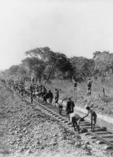
The first railway in the country, operated by Rhodesian Railways when the territory was administered as North-Western Rhodesia and North-Eastern Rhodesia, reached the Broken Hill mine as early as 1906, and the town became the northern base for the railway, which was the second biggest employer after the mining industry. A locomotive maintenance facility was constructed there. In 1909 the railway reached Ndola in what was to become the Copperbelt.
The railway workers' unions played a large role in the politics of the country. In racially segregated colonial times before Africans had the vote, the town was the seat of Roy Welensky, leader of the powerful Rhodesia Railway Workers Union (RRWU), who became Prime Minister of the ill-fated Federation of Rhodesia and Nyasaland, which was opposed by the Northern Rhodesia Railway Trade Union (the black Africans' union) led by Dixon Konkola and also based in Kabwe.[2]
Today, the town is the headquarters of Zambia Railways but employment levels on the railway have been heavily cut.
Kabwe's role in Zambia's independence
Reflecting Kabwe's central location and railway union base, it was chosen as the site for a rally held on October 26, 1958 at Mulungushi Rock north of the city by the Kaunda-Kapwepwe breakaway group from the Zambian African National Congress. Later, they founded the political party UNIP which led the successful independence movement and continued to hold conferences at Mulungushi Rock, which became known as the 'birthplace of independence' in Zambia.[2]
Transportations
As well as being on the main Lusaka-Copperbelt railway line, it lies on the Great North Road.
 Shouldercarrying.
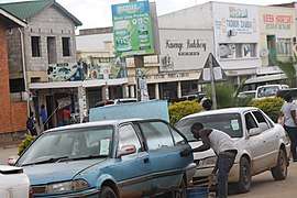 Taxis.
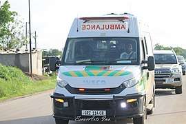 Ambulance.
Industries and agriculture
Closure of the mine led to economic decline for Kabwe.[4] It has a number of manufacturing industries including the Zambia-China Mulungushi Textiles plant established with Chinese investment in the 1980s, but after suffering large losses this plant closed (temporarily according to management) at the beginning of 2007.
Other industries include pharmaceuticals, milling and cotton ginning, and Kabwe's first Drinking Water Plant (Aquador Purifed Water) and leather tanning.[4]
To the east of the city are the hydro-electric power stations of the Mulungushi Dam, Mita Hills Dam and Lunsemfwa Falls, built to power the mine and town.
Commercial farming areas surround the city about 10 km from the centre, and the road and rail links provide ready access to the markets of the Copperbelt and Lusaka.
Climate
| Climate data for Kabwe | |||||||||||||
|---|---|---|---|---|---|---|---|---|---|---|---|---|---|
| Month | Jan | Feb | Mar | Apr | May | Jun | Jul | Aug | Sep | Oct | Nov | Dec | Year |
| Record high °C (°F) | 32.4 (90.3) |
31.5 (88.7) |
32.6 (90.7) |
33.0 (91.4) |
31.5 (88.7) |
30.4 (86.7) |
29.6 (85.3) |
33.4 (92.1) |
36.3 (97.3) |
38.6 (101.5) |
37.5 (99.5) |
34.1 (93.4) |
38.6 (101.5) |
| Average high °C (°F) | 27.0 (80.6) |
27.0 (80.6) |
27.0 (80.6) |
26.5 (79.7) |
25.2 (77.4) |
23.7 (74.7) |
23.5 (74.3) |
26.1 (79.0) |
29.8 (85.6) |
31.3 (88.3) |
29.8 (85.6) |
27.3 (81.1) |
27.0 (80.6) |
| Daily mean °C (°F) | 21.1 (70.0) |
21.0 (69.8) |
20.7 (69.3) |
20.0 (68.0) |
17.8 (64.0) |
15.9 (60.6) |
15.9 (60.6) |
18.4 (65.1) |
22.1 (71.8) |
24.1 (75.4) |
23.0 (73.4) |
21.3 (70.3) |
20.1 (68.2) |
| Average low °C (°F) | 17.3 (63.1) |
17.4 (63.3) |
16.5 (61.7) |
14.4 (57.9) |
11.4 (52.5) |
13.1 (55.6) |
8.7 (47.7) |
10.9 (51.6) |
14.5 (58.1) |
17.1 (62.8) |
17.6 (63.7) |
17.5 (63.5) |
14.7 (58.5) |
| Record low °C (°F) | 10.1 (50.2) |
11.9 (53.4) |
11.3 (52.3) |
8.2 (46.8) |
5.9 (42.6) |
3.0 (37.4) |
3.4 (38.1) |
3.6 (38.5) |
4.4 (39.9) |
8.9 (48.0) |
12.6 (54.7) |
9.4 (48.9) |
3.0 (37.4) |
| Average precipitation mm (inches) | 234.4 (9.23) |
179.4 (7.06) |
100.6 (3.96) |
27.5 (1.08) |
4.4 (0.17) |
0.1 (0.00) |
0.0 (0.0) |
0.1 (0.00) |
0.7 (0.03) |
18.1 (0.71) |
91.2 (3.59) |
251.2 (9.89) |
907.8 (35.74) |
| Average precipitation days (≥ 1.0 mm) | 20 | 16 | 11 | 3 | 0 | 0 | 0 | 0 | 0 | 2 | 10 | 19 | 81 |
| Average relative humidity (%) | 81.3 | 81.3 | 78.6 | 72.6 | 64.8 | 60.2 | 56.4 | 48.1 | 40.7 | 44.0 | 60.9 | 78.0 | 63.9 |
| Mean monthly sunshine hours | 179.8 | 165.2 | 220.1 | 258.0 | 282.1 | 279.0 | 300.7 | 316.2 | 297.0 | 285.2 | 222.0 | 173.6 | 2,978.9 |
| Source: NOAA[8] | |||||||||||||
Tourism potential
To the east and west of Kabwe are a number of areas with good but so-far undeveloped tourist potential, advantaged by Kabwe's central location and proximity to Lusaka and its international airport:,[9][10]
- Lukanga Swamp: 50 km west, with a wildlife area (currently a Game Management Area) on the other side of the Kafue River, 120 km from Kabwe, but road access is very poor.
 A resident fisherman enters Lukanga Swamp about 60 km west of Kabwe, Zambia. Fisher families live in papyrus shelters on floating mats of vegetation within the swamp. The national bird, the fish eagle, may be seen hunting for its prey in the swamp.
 - Mulungushi River & Lunsemfwa River valleys, including Lunsemfwa Wonder Gorge: these two rivers flow into the western end of the Luangwa Rift Valley just over 50 km south-east of Kabwe, and just south of the Mulungushi Dam and lake which offers good boating and game fishing activities. The valleys are scenic wilderness with good wildlife potential. However, there is no proper road access to the area.
 About 75 km east-southeast of Kabwe, Zambia, the Lunsemfwa River cuts a 500m deep gash, known as The Wonder Gorge, through the lip of the Muchinga Escarpment (viewed from Bell’s Point). The antenna atop the Taipei 101 skyscraper, the world’s second-tallest building, would just protrude above the rim of this gorge.
 - Chifunkunya Hills: 150 km east, a wilderness area of rugged granite mountains rising 1000 m above the Luangwa Valley, just to the north-west of the confluence of the Lunsemfwa and Lukusashi Rivers, with no road access.
Institutions and attractions
- Mulungushi Rock of Authority, north of the city
- Mulungushi University
- Lunsemfwa hydro power company
- Radio Maranatha 103.3 FM, run by the Zambia Union Conference of the SDA Church
- Kabwe Warriors football club, one of the top three teams in the country
- Bwacha House National Monument: Number E1376 Musuku Road, Bwacha Township, where on 8 March 1958 Kenneth Kaunda was elected President of the Zambian African National Congress
- Big Tree National Monument: a fig tree with a 50 m wide canopy on the east side of Broadway, which served as a meeting place on many occasions during the early years of the town's history
- Broken Hill Man memorial at Kabwe municipal offices
- Zambia National Service Training School
- Chindwin Barracks and Kohima Barracks (Zambian Defence Force)
- Nkrumah University
- Mukobeko Trades Training Institute (changed to Kabwe Trades Training Institute)
- Kabwe Trades Training Institute changed to Kabwe Institute of Technology-
- Kabwe Institute of Technology
- Kabwe Mall
- National Fire Fighting Services Training School
- Kabwe golf course
- Mulungushi Boat Club, Mulungushi Dam
- Inshindo Foundation, a Baha'i-inspired organization offering the Preparation for Social Action Program in Kabwe
- King George National college (under ministry of youth and sport)[4]
- Power Fm ( The People's Station )
- Kabwe Town Library
- Kwame Nkrumah University, a public institution of higher education
- Paglory University
- Ellensmere High School
Bus crash
On February 7, 2013, a bus collided with two cars near Kabwe, killing 53 people. It was one of the worst road accidents in Zambian history.
Notable Kabweans
- Wilbur Smith, novelist
- Michael Norgrove, boxer
- Tutwa Ngulube, politician
- Chansa Chishimba, Software Engineer
References
- "Kabwe (District, Zambia) - Population Statistics, Charts, Map and Location". www.citypopulation.de. Retrieved 2020-05-30.
- The Times of Zambia online Archived 2006-10-12 at the Wayback Machine, website accessed 8 March 2007: "Kabwe: the nucleus of national politics" by Kelvin Kachingwe.
- "Kabwe | Zambia". Encyclopedia Britannica. Retrieved 2020-05-30.
- Zamnet Online News: Archived 2007-10-23 at the Wayback Machine "Kabwe: From discovery to recovery" (Daily Mail), website accessed 7 March 2007.
- Bruce Kapferer: "Strategy and Transaction in an African Factory", Manchester: Manchester University Press 1972
- The Blacksmith Institute website accessed 1 March 2007.
- J. Yabe et al., "Lead poisoning in children from townships in the vicinity of a lead–zinc mine in Kabwe, Zambia", Chemosphere 119 (January 2015), 941-947, doi:10.1016/j.chemosphere.2014.09.028.
- "Kabwe MET Climate Normals 1961–1990". National Oceanic and Atmospheric Administration. Retrieved January 22, 2014.
- Camerapix: "Spectrum Guide to Zambia." Camerapix International Publishing, Nairobi, 1996.
- Google Earth accessed 2007.